
• Skip to main content
  • Skip to secondary menu
  • Skip to primary sidebar
  • Skip to footer
Geographical

Geographical

Official magazine of the Royal Geographical Society (with IBG)

  • Geographical Home
  • News
  • Features
  • Opinion
    • Climatewatch
    • Front Lines
  • Podcast
  • Travel
    • Discovering Britain
    • Passport
  • Culture
    • Book reviews
  • Quizzes
    • Crosswords
  • Choose Geography
    • University directory
    • Masters courses
    • Course guides
      • Climate change
      • Environmental science
      • Human geography
      • Physical geography
    • University pages
      • Aberystwyth University
      • Brunel University
      • Cardiff University
      • University of Chester
      • Edge Hill University
      • The University of Edinburgh
      • Newcastle University
      • Nottingham Trent University
      • Oxford Brookes University
      • The University of Plymouth
      • Queen Mary University of London
    • Geography careers
      • Charity/non-profit
      • Education & research
      • Environment
      • Finance & consulting
      • Government and Local Government
    • Applications and advice
  • Magazine
    • Issue previews
    • Subscribe
    • Manage My Subscription
    • Special Editions
    • Geographical Archive
    • Advertise with us
  • Subscribe
    • Direct Debit Changes

Phenomena: Antarctica’s hidden landscape

27 October 2026
3 minutes

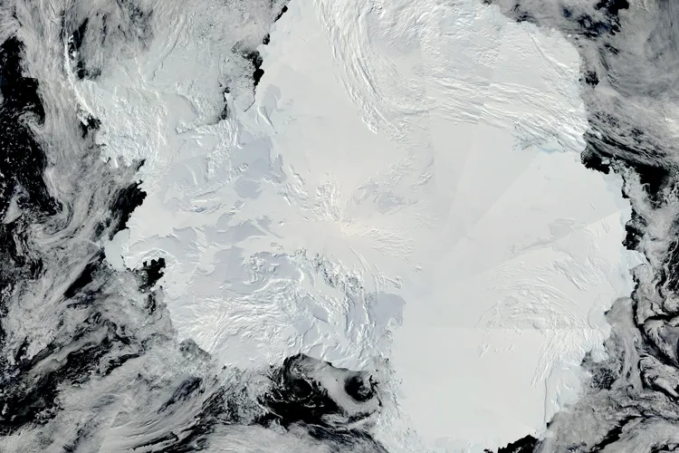
Satellite view of Antarctica’s ice-covered surface
Antarctica’s ice-covered surface conceals a landscape of mountains, valleys and plains. Image: NASA

Scientists are uncovering ancient rivers, mountains and vast canyons hidden beneath Antarctica’s ice, revealing clues about the continent’s past and its future in a warming world


By Grace Gourlay

At first glance, Antarctica can appear relatively featureless: a vast expanse of white stretching across the bottom of the planet. But beneath its enormous ice sheet lies an altogether different landscape, filled with mountains, deep canyons, valleys and plains that, in many places, haven’t seen daylight for millions of years.

Seeing this hidden world is no easy task. Antarctica’s ice is more than two kilometres thick on average and reaches almost 4.8 kilometres at its deepest point, meaning scientists can’t simply observe the landscape beneath it. Traditionally, researchers have used radar aboard aircraft to peer through the ice, gradually building up a picture of the bedrock below.

The sheer size of Antarctica, however, makes mapping the entire continent difficult. Survey flights can be separated by tens of kilometres, leaving researchers to fill in large gaps between individual measurements. More recently, scientists have begun combining these observations with satellite data and an understanding of how ice moves across the landscape beneath it.

Antarctic landscape with mosses in the foreground
Despite its freezing temperatures, some parts of Antarctica can provide a habitat for moss to grow. Image: Shutterstock

The principle is surprisingly simple. Just as water flowing over a submerged rock can produce ripples and eddies at the surface, hills and ridges beneath Antarctica can leave subtle clues in the ice flowing above them. By studying the shape and movement of the ice, researchers can therefore learn more about the landscape hidden underneath.

Using this approach, scientists have revealed tens of thousands of previously unmapped hills and ridges, alongside new details of buried mountains and canyons. Among the features identified is an enormous channel in the Maud Subglacial Basin, measuring around 50 metres deep and six kilometres wide. It stretches for almost 400 kilometres beneath the ice – roughly the distance from London to Newcastle.

Other discoveries offer glimpses of an Antarctica that existed long before it became the frozen continent we know today. Beneath East Antarctica, researchers have identified ancient, remarkably flat surfaces thought to have been shaped by large rivers before the continent was engulfed by ice around 34 million years ago. Some of these landscapes appear to have survived beneath the ice largely intact for more than 30 million years.


Enjoying this article? Check out our related reads…

  • Geo Explainer: Antarctica
  • A France-sized piece of ice is missing from Antarctica’s West Coast
  • Charting the course of human intervention on Antarctica with objects
  • Tourism visitor numbers in Antarctica have risen to over 100,000 a year
  • Applications open for jobs in Antarctica with BGS

Scientists are now piecing these discoveries together to create increasingly detailed maps of the continent. In 2025, researchers released Bedmap3, the most detailed map yet of Antarctica’s bedrock, assembled from more than six decades of measurements gathered by satellites, aircraft, ships and even dog-drawn sleds.

The map allows Antarctica to be viewed as though its 27 million cubic kilometres of ice had been stripped away, revealing the mountains, valleys and canyons concealed below.

Mapping this hidden world is about more than discovering what Antarctica looks like underneath. The shape of the bedrock influences how the ice above it moves: ridges can slow its flow, while valleys and deep troughs can provide routes along which glaciers accelerate. Understanding this landscape can therefore help scientists model how Antarctica’s enormous ice sheet may respond as the climate warms.
Themes News Antarctica Glaciers Mapping November 2026 issue Phenomena

Protected by Copyscape

Primary Sidebar

SUBSCRIBE

GEOGRAPHICAL WEEKLY LOGO FREE - Sign up to get context, clarity and perspective in a noisy world, every Friday
GIVE A GIFT

Give a year of Geographical - order a gift subscription

Popular Now

December 2026 Geographical Magazine cover

Out now: December 2026’s Geographical Magazine

Images released by Survival in 2024 showed dozens of Mashco Piro people dangerously close to logging concessions

Peruvian government blocks proposal to protect uncontacted Indigenous people’s territory

Thermometer displaying a high temperature in degrees Celsius and Fahrenheit with a radiant sun on a background of blue sky. Concepts of summer, hot weather, excessive temperatures and heat waves

This year ‘virtually certain’ to exceed 1.5°C, Copernicus warns

Sandy beach in Margate, Kent, England

‘Significant deposits of oil’ found on 18 Kent beaches

Marshland in Doñana

The lagoon that fit the bill

Footer

  • Facebook
  • Instagram
  • LinkedIn
  • Reddit
  • TikTok
  • Twitter
  • YouTube

Geographical print magazine cover

Published in the UK since 1935, Geographical is the official magazine of the Royal Geographical Society (with IBG).

Informative, authoritative and educational, this site’s content covers a wide range of subject areas, including geography, culture, wildlife and exploration, illustrated with superb photography.

Click Here for SUBSCRIPTION details

Want to access Geographical on your tablet or smartphone? Press the Apple, Android or PC/Mac image below to download the app for your device

Footer Apple Footer Android Footer Mac-PC

More from Geographical

  • Subscriptions
  • Get our Newsletter
  • About Us
  • Contact Us
  • Advertise with us
  • Privacy policy
  • Terms & Conditions

Copyright © 2026 · Site by Syon Media