A digital journey through The Sunderland Collection’s maps of the Earth and sky
The Sunderland Collection is a treasure trove of 13th-19th century terrestrial and celestial maps. But these aren’t just guides to a physical location; they are works of art, historical documents, and windows into the human imagination. Each piece tells a unique story of discovery and the enduring quest to understand the world.
According to custodian Helen Sunderland-Cohen, the collection began ‘very organically’, not with a grand master plan, but with her father’s simple love of maps. This passion was sparked during his childhood by a map of Lancashire belonging to his uncle – a document that charted Neil Sunderland’s own ‘little local universe’. As her father began to travel, his passion evolved. It became less about souvenirs of the places he visited – including remote overland journeys from London to India, or a summer spent in Ethiopia – and more about finding ‘exceptional examples of important or influential items,’ says Sunderland-Cohen. Maps that told a larger story about the evolution of human knowledge and the wonder of exploration.
Want to know more? Check out our related reads:
A personal history
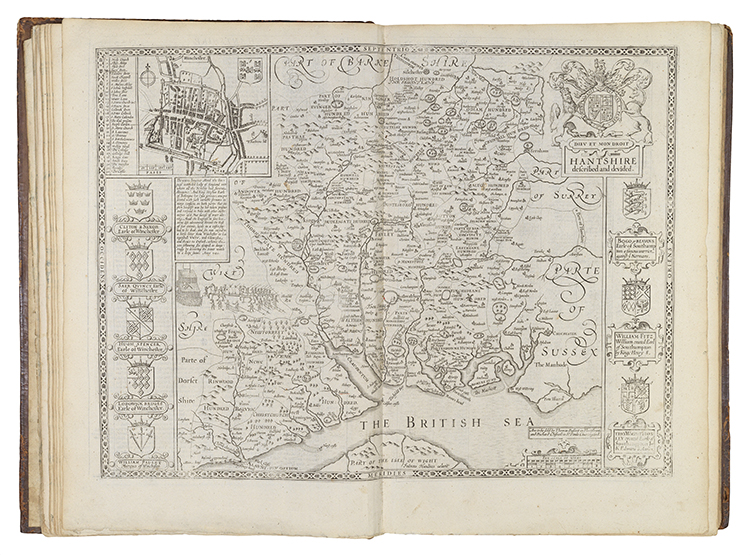
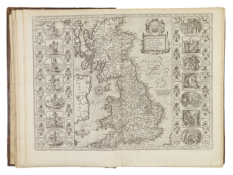
One of the most humble-looking yet captivating pieces in the collection – a John Speed Atlas from 1606 – holds a special personal significance for Sunderland-Cohen. She remembers seeing it for the first time as a teenager and being ‘fairly blown away that anything was that old’. Titled The Theatre of the Empire of Great Britaine, the atlas was published in London to provide a complete and authoritative survey of the British Isles, which were newly united under King James I. It was a monumental achievement, becoming the first work of its kind to include detailed, hand-coloured maps of all the counties of England, Wales, Scotland, and Ireland, along with plans of their major towns and cities. Yet, for Sunderland-Cohen, the atlas’s real magic lies in its personal details. Holding the leather-bound book, she says, ‘you can imagine somebody else touching that leather and turning the pages’. The atlas is made even more special by a former owner’s handwritten notes, scribbled in ‘old brown ink, with funny letters about John Speed.’
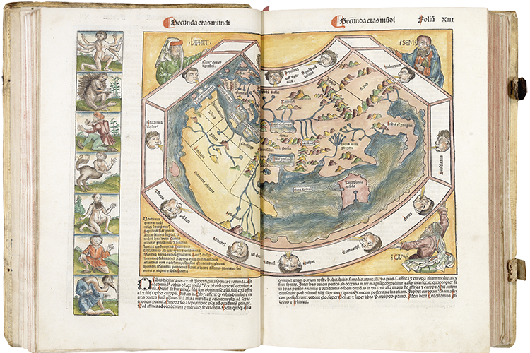
Another standout piece in the collection is the Nuremberg Chronicle map of 1493, a fascinating snapshot of the world on the cusp of global exploration. Created using a woodblock print just before Christopher Columbus’s discoveries were made public, the map is, in Sunderland-Cohen’s words, a ‘mad amalgam of what people thought was true at the time.’ Using the Ptolemaic projection (a method used to depict the spherical Earth as a flat, conical image), the map blends ancient cartographic knowledge with the imagination and folklore, filling in the blanks with mythical creatures and people – including the three sons of Noah, who were thought to have repopulated the Earth after the Great Flood.
Another highlight from the collection that perfectly blends science and art is a stunning Blaeu world map from the early 17th century. On the surface, it’s a detailed map showing the Mercator projection, but what truly captivates Sunderland-Cohen are the decorative elements. ‘It’s got everything, from geographical details and the Seven Wonders of the Ancient World, to sea monsters and the four seasons personified.’
An enduring art
While technology has transformed cartography, the fundamental human impulse to map the world has remained unchanged. According to Sunderland-Cohen, maps today, even in their digital forms, are still a reflection of the decisions and perspectives of their creators. ‘Even when you’re looking at Google Maps, decisions have been made in the background about what to include or how to present things,’ she notes. Like the fantastical maps of the past, with their mythical beasts and decorative flourishes, modern maps are not purely objective. They are a form of graphic design, ‘taking either enormous areas or enormous ideas’ and figuring out how to represent them on a flat surface.
Sunderland-Cohen believes this blend of artistry and function is why maps, especially those that are hand-drawn or decorative, continue to captivate us. While they have evolved from detailed woodblock prints to the satellite imagery of today, their purpose – to make sense of the world – is as timeless as ever. The popularity of hand-drawn maps in fantasy series like Game of Thrones or Lord of the Rings, and the work of modern cartographers like Adam Dant, proves there is still a powerful love for this ancient medium. ‘I think there’s something about the materiality of a map… they are such unusual objects because they are drawn, and because they’re so subjective.’

A digital collection
For a while, The Sunderland Collection remained in storage, the maps accessible to only a few. To Sunderland-Cohen and her father, this felt like a bit of a waste. ‘The goal was to move beyond simply owning the items and to let others experience the same sense of magic, inspiration, and excitement that the family felt. As Helen put it, ‘We were very privileged to own objects like this, and owning something for ownership’s sake just felt a bit weird.’ They had a responsibility, they felt, to share these extraordinary historical objects.
The solution was the Oculi Mundi digital collection. The project began by digitising everything, a decision driven by a dual purpose: it created a comprehensive digital record for collections management and, more importantly, it made the collection widely accessible. Recognising that a physical museum would be costly and limited in reach, Helen and her team opted to create a virtual space with ‘maximum flexibility’, embracing the fact that ‘nowadays, the internet offers the greatest accessibility.’
The team collaborated with architects to study how people interact with maps and navigate spaces, even going so far as to analyse how we engage with flat materials, to create the ideal website design. From the outset, Sunderland-Cohen explains, the goal was not to replicate a physical museum. Instead, Oculi Mundi offers an ‘explore’ mode that allows users to digitally wander through the maps, and a ‘research’ mode, which provides a familiar, chronological layout with extensive catalogue information. ‘It’s been immensely rewarding to see how people engage with the collection,’ she says.
The Sunderland Collection is a private collection of rare antique cartography, including maps, atlases, globes, and books of knowledge, dating from the 13th to the early 19th centuries. It was founded by Dr. Neil Sunderland and is now managed by Helen Sunderland-Cohen, who oversees all aspects of the collection, from acquisitions to its digitisation and public access.

The Sunderland Collection with the Royal Geographical Society symposium, Challenging Maps and Exploration – Cartographic Encounters with Empire, Indigeneity, and Contemporary Exploration
9.30am – 4pm, 30 October 2025
Education Centre, Royal Geographical Society, 1 Kensington Gore, London SW7 2AR, and online at RGS.org
Free of charge, register here

The Sunderland Collection Art Programme exhibition, Kristina Chan: Impossible Measures
1 – 28 October 2025, 10am – 5pm, open to RGS Fellows and Members only
Director’s Gallery, Royal Geographical Society, 1 Kensington Gore, London SW7 2AR
To arrange a visit for non-RGS Fellows and Members, or for further information about the works including pricing and availability, please contact [email protected]