The lifeboat at the world’s end – an icy, unhabitated island only few have seen
By
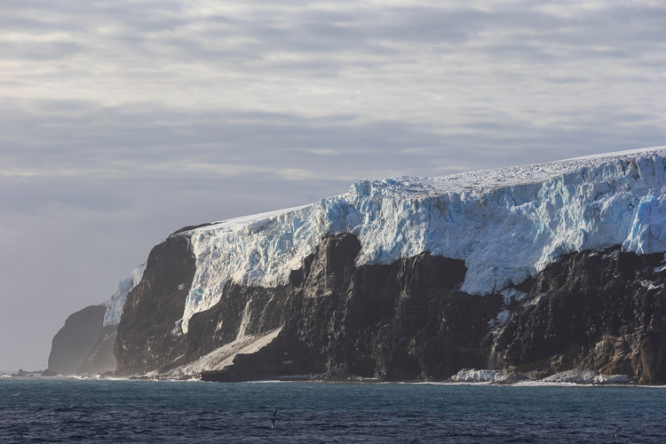
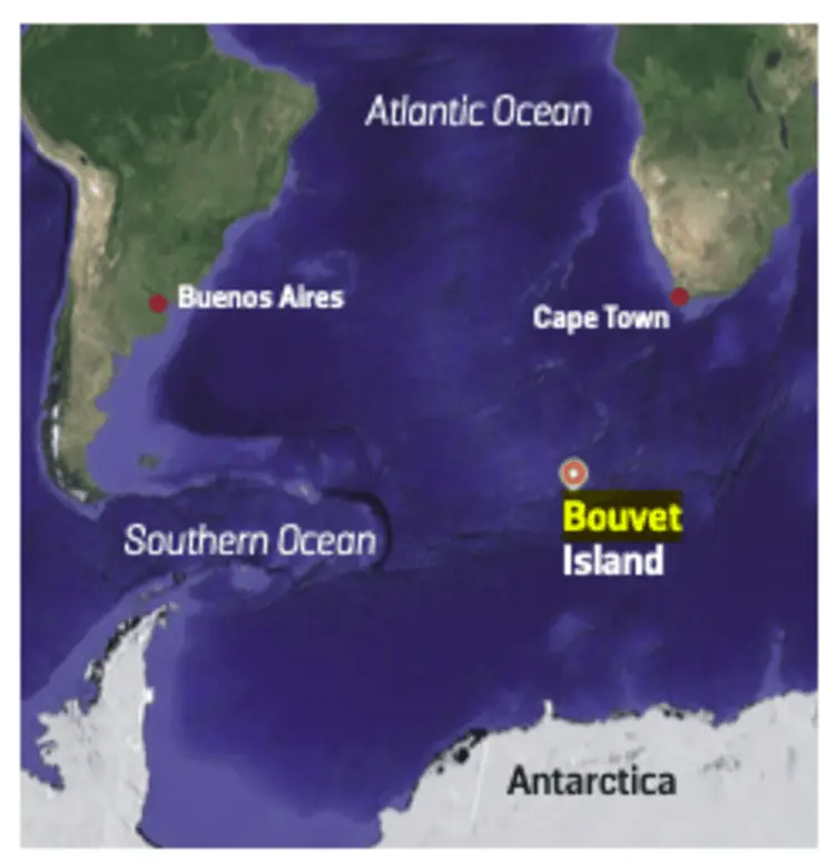
Far out in the subantarctic, well beyond the usual paths of navigation, lies a forgotten fragment of land: Bouvetøya, or Bouvet Island. Icy, uninhabited and surrounded by thousands of miles of ocean, it’s a place few have seen – but one that holds a quietly remarkable mystery. This Norwegian dependency is a speck of ice and volcanic basalt in the Southern Ocean, often called the most isolated island on Earth. You could draw a 1,600-kilometre circle around it that contains no other land.
Bouvet Island, lying south of the Roaring Forties, has a history marked by being lost – evading cartographers for decades after its 1739 discovery. Norway formally claimed Bouvet Island in 1928, later incorporating it as a dependency under the Antarctic Treaty System, though its extreme isolation means no permanent human presence has ever been established. It wasn’t until the late 1950s that a safe landing spot appeared: the Nyrøysa (‘New Mound’), a small, low-lying lava platform created by a volcanic eruption between 1955 and 1958.
Despite its isolation, Bouvet Island is a living laboratory. Its steep ice cliffs, volcanic slopes and growing lava plateau make it one of the youngest and least disturbed volcanic islands on Earth. Designated a nature reserve by Norway in 1971, it supports colonies of chinstrap and macaroni penguins, Antarctic fur seals and rare mosses clinging to the black basalt.
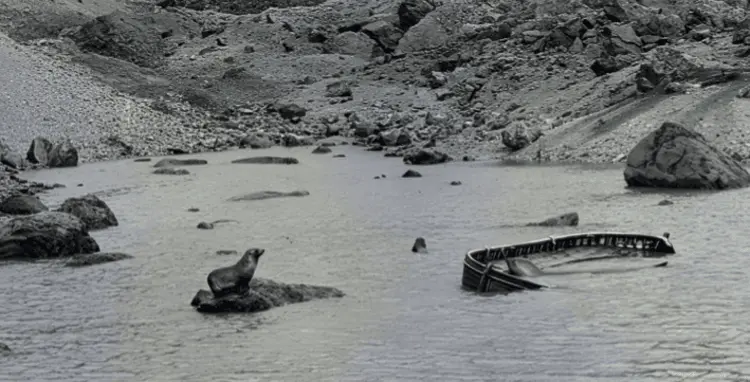
It was on this new land, on 2 April 1964, that a survey team from the Royal Navy’s HMS Protector, led by Lieutenant Commander Allan Crawford, made an astonishing find.
Floating in a small lagoon, protected by seals, lay an abandoned, half-swamped boat. Crawford described it as an unidentifiable ‘whaler or ship’s lifeboat’. A hundred metres away, they found a 44-gallon drum, a pair of oars and a copper buoyancy tank that had been inexplicably flattened.
The mystery was immediate and profound. How had it possibly made it across thousands of miles of the Southern Ocean? Even more unsettling, there was no camp, no shelter – and no trace of anyone who might have arrived in it. The boat’s presence just didn’t make sense. If it had been a lifeboat from a shipwreck, why was it floating in the lagoon – the only available shelter – instead of being used as an upended shack?
Enjoying this article? Check out our related reads:
The lack of bodies and the implausibility of an open boat navigating to such a small, hard-to-find target led to decades of speculation. The most credible solution was eventually found hiding in a little-seen Soviet document: Transactions of the Oceanographical Institute (Moscow, 1960). In November 1958, a group of scientists and sailors from the Soviet whaling flotilla Slava landed on the Nyrøysa. According to the record, an ‘unexpected hurricane’ forced the group to spend three days there.
This detail is compelling. It suggests the boat was a landing craft from a Soviet whaler, likely abandoned in an emergency evacuation – perhaps by helicopter – when the sudden storm made a recovery by ship impossible. The secrecy of the Cold War era would easily explain why the visit went undocumented.
The island has seen only a handful of visitors since. The Norwegian Polar Institute maintains an automatic weather station there, last serviced in 2012 by helicopter. In 2019, a Norwegian expedition attempted to revisit the site of the lagoon but was forced back by heavy seas and drifting ice. The rusted remains of the boat, if still there, have never been photographed again.
The Bouvet Island lifeboat seems to belong to a forgotten chapter of Antarctic history – a relic from a Soviet expedition, abandoned and left to slowly decay on one of the most remote coastlines on Earth.