Discover more about how tsunami warning systems operate, where they are utilised, and how technology is shaping their operations
By
Earlier today, an 8.8-magnitude quake struck off Russia’s eastern coast, triggering tsunami warnings for various nations around the world. From Hawaii to Japan and even parts of the US, countries and regions have warned their citizens to move away from high-risk areas, like beaches and waterways, as large waves encroach closer. Some waves around 30cm above tide levels have been observed in the Alaskan communities of Amchitka and Adaka.
But how exactly do these sophisticated tsunami warning systems work – and how is innovative technology helping to shape them? Read on to find out…
What is a tsunami?
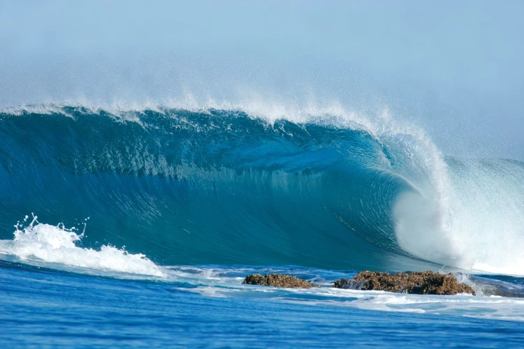
Essentially, a tsunami is a series of giant waves caused by earthquakes or volcanic eruptions under the sea. Around 80 per cent of all known tsunamis have been triggered by earthquakes.
Out in the ocean, tsunami waves do not take on the appearance typically seen in photographs – huge, cresting waves that dwarf buildings and other structures. However, as they travel inland, they build up to become higher and higher.
Enjoying this article? Check out our related reads:
The speed of tsunami waves depends on the ocean depth, rather than the distance from the source of the wave. In deep waters, tsunami waves may travel as fast as jet planes – around 500 miles per hour – over deep waters, and only slow when reaching shallow waters.
Tsunamis can strike any coast at any time, but typically they occur along large faults that can generate large earthquakes.
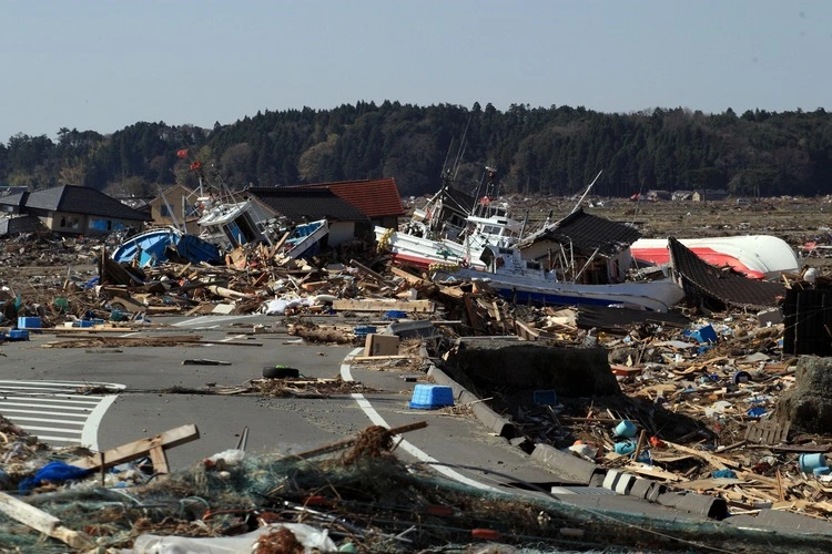
When they finally hit the coast, tsunamis can lead to dangerous coastal flooding and powerful currents that impact marine operations and navigation. As such, ensuring that effective warning systems are in place to mitigate their impacts is pivotal.
How do warning systems work?
Like the earlier Russian earthquake, a tsunami is usually preceded by a quake. These create seismic waves, travelling around 100 times faster than a tsunami, meaning they can be analysed far earlier than other methods.
Seismic networks – a collection of stations with the job to measure ground movement – can provide specific information about an earthquake’s location, depth and magnitude. Then, a tsunami warning centre can decipher such information in order to figure out if a tsunami may form, and consequently, whether a warning is required for citizens within the area.
If an earthquake meets a particular threshold, tsunami warning centres are able to use information from water-level networks, a system which monitors changes in the water using sea-floor sensors and surface buoys. Together, these can determine the presence and size of a tsunami.
Tsunami warning centres will run forecast models to simulate how a tsunami may behave across the ocean in terms of wave height, arrival time on land, location and duration. Such measurements are then used by scientists to decide if an update should occur, or whether a warning can be cancelled. For US and Canadian coasts, warning centre scientists can typically issue initial alerts within five minutes of an earthquake.
In the US, tsunami warning centres are part of a larger tsunami warning system that aims to minimise the natural phenomenon’s impacts. Two tsunami warning centres are manned 24 hours a day, seven days a week.
As well as the US, Japan boasts one of the world’s most comprehensive warning systems. Data is continuously collected using satellites and cellular communication from its six observatories. After an earthquake occurs, any observatories close to the epicentre will issue tsunami bulletins. Within three minutes, tsunami warnings are then broadcast. Notification methods include fire-trucks equipped with loudspeakers, television and radio messages that interrupt general broadcasts, alongside sirens and bells in villages.
Many tsunami centres are created following damaging tsunamis in the area. For example, the Pacific Tsunami Warning Centre in Hawaii was established following a 1946 tsunami that struck Hawaii, killing more than 150 people and leading to more than $300 million in damage. As well as this, the National Tsunami Warning Centre in Alaska was created after the largest recorded earthquake in US history generated several tsunamis in 1964.
Levels of alerts
In the US and Canada, there are four tiers of alerts for tsunamis. The lowest is an information statement, which means there is no threat or a very distant event. A tsunami watch means a distant tsunami is possible, while an advisory stipulates strong currents and waves are dangerous to those in or very near the water. At this stage, officials state individuals should stay out of the water and head away from beaches and waterways.
The highest level is a tsunami warning, which means dangerous coastal flooding and powerful currents are possible. In this case, the message is clear: move to high ground or inland.
If a tsunami is suspected, messages may also include wave arrival times, recommended actions and potential impacts. Such messages are sent through a variety of means to a plethora of channels, including other officials, news media and the general public.
Technology helps
Although traditional tsunami warning systems are helpful, they do have their own host of disadvantages. For example, seismometers can detect earthquakes but struggle to provide reliable tsunami measurements, leading to false alarms and potential false negatives. Numerical models can take an extremely long time to process and are mostly used for post-processing, whereas pre-calculated models offer a high risk of false negatives.
As such, AI technology is helping to make the operations of tsunami warnings more slick.
One research team from the University of Cardiff has developed AI-based models that analyse sound signals recorded by underwater hydrophones. These signals travel much faster than tsunamis, at the speed of sound. AI models can analyse streamed sound signals, determining earthquake type and magnitude to predict tsunami generation in a fraction of a second. Such a technological advance is particularly important given that the majority of tsunamis are caused by earthquakes.
Consequently, these models can provide more accurate and timely warnings, reducing false alarms and improving response measures. However, AI models require continuous research and development to ensure models are as current as possible.


