Image: Frans Delian/Shutterstock
The 9.1-magnitude Sumatra earthquake led to the deadliest-ever tsunami, killing nearly 230,000 people as it ravaged across the Indian Ocean
by Victoria Heath
On Boxing Day 2004, a 9.1-magnitude earthquake was recorded off the coast of Sumatra Island, Indonesia. A 900-mile stretch of fault line was ruptured where the Indian and Australian tectonic plates meet, causing the ocean floor to rise by around 40 metres. Also known as the Sumatra-Andaman earthquake, the disaster led to the deadliest-ever tsunami recorded.
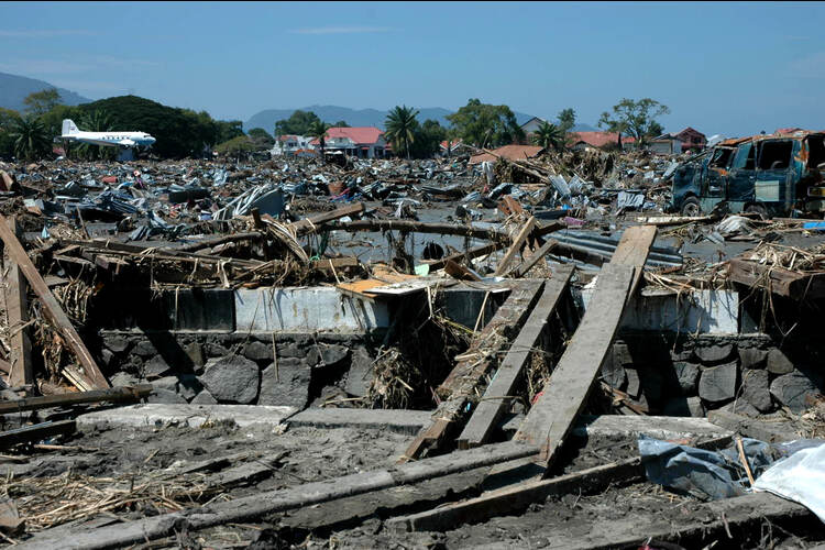
Aftermath of Sumatra earthquake and tsunami in Indonesia
The resultant tsunami occurred within just 20 minutes of the Sumatra earthquake. 100-foot waves hit the shores of Banda Aceh in Indonesia, killing over 100,000 people.
The western part of the city of Banda Aceh has almost flat topography. Waves reached between 4-8 metres high in these areas, reaching higher numbers in hilly areas south of Banda Aceh.
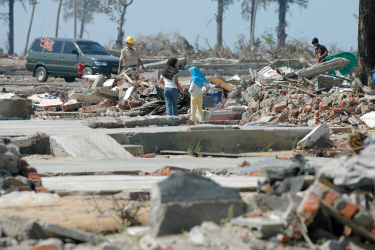
If buildings in the area survived the initial shaking caused by the earthquake, most were devastated by tsunami waves. Debris caused by the impact of three successive waves tsunami waves caused large projectiles such as cars, trucks and boats, to impact facilities which were previously undamaged. The supports holding up roads and bridges were swept away, and hundreds of bridges were destroyed.
According to the UN Field Office, approximately 131,000 people were confirmed dead, and 37,000 were reported missing in the northern province of Aceh in Sumatra. Eighty thousand houses suffered from major damage or collapsed entirely, and more than 500,000 people in Sumatra were displaced from their homes.
Tsunami impact elsewhere
The devastation quickly spread to Thailand, India and Sri Lanka coastlines, with tsunami waves travelling across the Indian Ocean at 500mph. Eight hours after the earthquake, over 5,000 miles away, the tsunami hit the coast of South Africa. In total, the disaster killed nearly 230,000 people across 15 countries.
What caused the earthquake and tsunami?
Known as a megathrust quake, the earthquake occurred due to a heavy ocean plate slipping underneath a lighter continental plate. The disaster was caused by the India Plate subducting (being forced under) the Burma micro-plate, which forms part of the larger Sunda plate.
The earthquake itself is estimated to have released the equivalent energy of 23,000 Hiroshima-type atomic bombs, and was so large that the planet’s rotation changed as the Earth’s mass shifted.
Learning from the Sumatra earthquake
Three weeks after the tsunami, representatives of 168 nations agreed to the Hyogo Framework for Action which encouraged global support and cooperation for disaster risk reduction.
Around $7 billion in aid was contributed by the Indonesian government, NGOs, donors and individuals. In Aceh, the government established a high-level bureau in order to organise recovery work.

At the time of the disaster, there was no official tsunami warning system, with the last major tsunami occurring in 1883. Some small island communities possessed tsunami knowledge from stories of tsunamis passed down through generations, which helped prevent further loss of life.
However, other witnesses came to the water in order to explore the ocean floor, or went about continuing their daily activities. Although signs such as withdrawal of the sea, and unusually large (but not damaging waves) were present, these were not widely understood as warnings.

To detect and warn of underwater earthquakes sooner, ocean floor earthquake sensors have since been installed, alongside training local communities in disaster response and evacuation. Now, national tsunami warning centres are also established in countries in the Indian Ocean region which can help alert citizens of imminent disasters.
If you enjoyed this article subscribe to the Geographical Archive to read more about what happened in 2004.
Enjoying this article? We have thousands more for you.
Get immediate access to over 1,000 Geographical magazines in our archive back to 1935.
Sign up today and you will soon be travelling back through time reading all our amazing features of the last eight decades PLUS… you also get to enjoy every new issue of Geographical each month going forward in both print and digital formats.
Simply press the button below to choose the perfect package for you.