The biggest recorded earthquake reached a magnitude of 9.5. Here are the 10 biggest earthquakes in history with the largest magnitudes ever recorded
An estimated 500,000 detectable earthquakes take place around the world each year, about 100,000 of which can be felt and 100 of which cause damage. They are largely caused by dramatic and sudden ruptures along the fault lines between tectonic plates, as decades or centuries of pressure, built-up as the plates move past each other and become stuck, is released. Most of the large earthquakes happen under our oceans and many of the deaths are caused by tsunamis triggered by the original earthquakes, which go on to cause damage far away from the site of the earthquake itself. The majority of earthquakes, around 80%, take place on the outskirts of the Pacific Ocean, the ‘Ring of Fire’ is the most volcanically and seismically active region in the world.
Top 10 by magnitude

1
Great Chilean Earthquake
Magnitude: 9.5 • Deaths: 1,655 • Date: 22 May, 1960
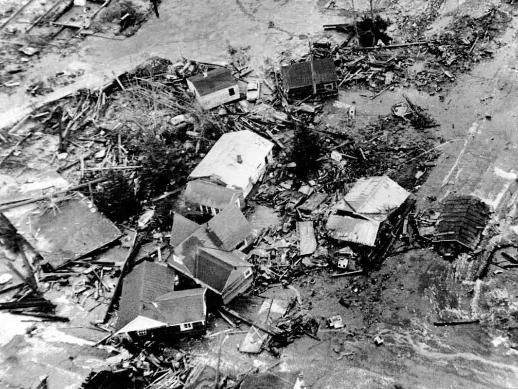
The largest earthquake ever recorded struck at 3.11 pm on 22 May 1960 about 160 kilometres off the coast of Chile, opposite the city of Valdivia. It began in the subduction zone (the place where one tectonic plate slides beneath another) of the Nazca and South American plates, when the sudden release of built-up energy saw the former descend 15 metres beneath the latter.
Most of the resulting casualties and much of the damage were caused by large tsunamis spawned by the quake, which struck locations as far away as Hawai’i, Japan, California and the Philippines. Two days after the earthquake, the nearby Puyehue volcano erupted, sending ash and steam up to six kilometres into the atmosphere over a period of several weeks.
2
Great Alaska Earthquake
Magnitude: 9.2 • Deaths: 128 • Date: 28 March 1964
It struck on Good Friday at 5.30 in the late afternoon and was the largest earthquake recorded in the USA. The epicentre was just offshore to the southeast of Anchorage in Prince William Sound and caused a tsunami which resulted in fatalities as far afield as California. Large areas of Anchorage were razed by landslides and parts of Kodiak 320km (200 miles) away were permanently raised by nine metres (30ft).
3
Sumatra Earthquake
Magnitude: 9.1 • Deaths: 227,900 • 26 December 2004
One of the most devastating earthquakes in recorded history began at the boundary between the vast Indo-Australian Plate and the smaller Burma Plate, where the former is being subducted beneath the latter. On Boxing Day 2004, the sudden release of pressure at this boundary caused the floor of the Indian Ocean to lurch some 15 metres towards Indonesia, forcing the Burma Plate upwards and generating a tsunami.
In total, 227,900 people were killed or presumed dead, with another 1.7 million displaced across 14 countries in South Asia and East Africa. The tsunami was so strong that its final victims were killed nearly eight hours after the initial quake, when swelling seas and rogue waves caught swimmers by surprise in South Africa.

4
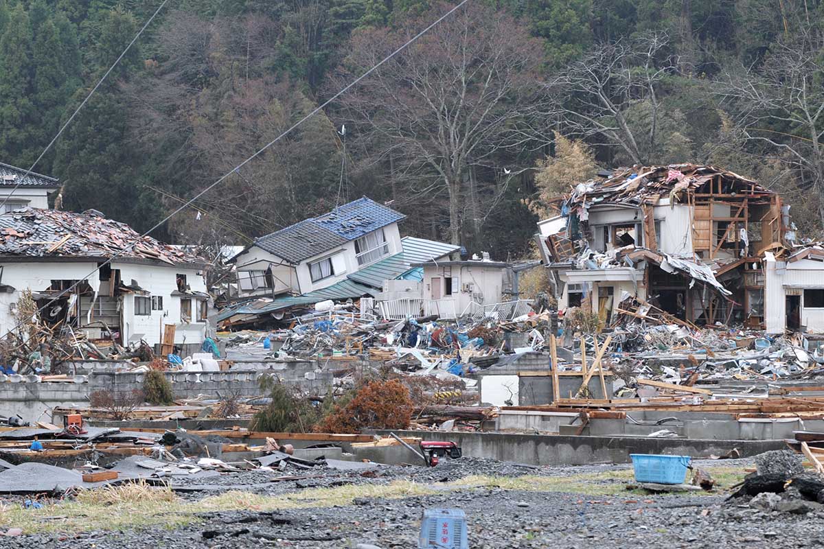
Tōhoku Earthquake, Japan
Magnitude: 9.1 • Deaths: 19,757 • Date: 11 March 2011
The Tōhoku earthquake, which occurred near the northeast coast of Honshu, Japan, was caused by a rupture in the subduction zone between the Eurasian Plate and the Pacific Plate. A part of the zone measuring about 300 kilometres long by 150 kilometres wide lurched as much as 50 metres to the east-southeast and was thrust upwards about ten metres. Along with large numbers of deaths, injuries and displacements, at least 332,395 buildings, 2,126 roads, 56 bridges and 26 railways were destroyed or damaged by the earthquake and the resulting tsunami along the entire east coast of Honshu.
The tsunami led to the Fukushima nuclear accident when waves damaged the backup generators at the Fukushima Daiichi plant. The quake was one of the most expensive natural disasters ever recorded, causing damage of up to US$309 billion.
A word on measuring magnitude
The Richter Scale is the most famous way of measuring earthquakes, but is now considered outdated. A new scale, called moment magnitude has now replaced the Richter Scale as the standard for measuring large earthquakes worldwide. The Richter Scale assigns a magnitude based on the largest jolt of energy recorded on a seismograph, plus the distance of the seismograph from the earthquake source. However this method is unable to distinguish between very large earthquakes. It also fails to take into account the fact that different types of rock may absorb differing amounts of energy between the source and the seismic station. Moment magnitude measures the total amount of energy released by an earthquake and is instead based on something called the seismic moment (which represents the average fault slip multiplied by the area over which the slip occurs), plus the stiffness of the surrounding rocks.

5
Kamchatka Earthquake, Russia
Magnitude: 9.0 • Deaths: 2,336 • Date: 4 November 1952
The earthquake struck just off the southeastern tip of the Kamchatka Peninsula on the isolated far eastern coast of Russia where the Pacific and Okhotsk Sea plates converge. It caused a tsunami with waves reaching 18m (50ft) that spread down across the Pacific Ocean as far as New Zealand and across to Chile. It was the largest earthquake ever recorded in Russia.
The Tsunami reached as far as California and Hawaii, and the property damage in Hawaii was estimated at $11m in today’s currency.

Largest by fatalities
- Sumatra, 2004 227,900
- Tōhoku, Japan, 2011 19,757
- Assam, India ,1950 approx 4.800
- Kamchatka, Russia, 1952 2,336
- Chile 1960, 1,655
6
Biobio Earthquake, Chile
Magnitude: 8.8 • Deaths: 521 • Date: 27 February 2010
The quake struck in the early hours and hit the central part of the country and more than 80 per cent of the population felt the tremors which lasted more than three minutes.
It caused extensive damage, which was later estimated to have cost Chile more than US$30 billion. It has devastating effects on local people, displacing over 800,000 in Chile.

7
Ecuador Earthquake
Magnitude: 8.8 • Deaths: 676 • 27 February 2010
The very large thrust earthquake was centred in a sparsely populated part of the country. But the tremors shook the capital Quito more than 170 km (110 miles) away. It generated a large Tsunami that landed in Central America and even reached as far as Japan and San Franciso, that killed over 500 people.
It caused widespread damage, with buildings destroyed hundreds of kilometres from the epicentre. At least 676 people were killed and 16,600 people injured.
8
Rat Islands Earthquake, Alaska
Magnitude: 8.7 • Deaths: 0 • Date: 2 April 1965
This formidable earthquake on the isolated and barren Rat Islands group, part of the Aleutian Islands, straddling the northern Pacific between Russia and Alaska, caused very little damage despite its scale. The earthquake caused a Tsnunami more than 10 feet high. Most of the reported $10,000 damage was to military runways in the strategically important US bases on nearby islands. There were no reported injuries.
9
Assam Earthquake
Magnitude: 8.6 • Deaths: 4,880 • Date: 25 March 1950
This is the largest earthquake ever recorded on land with the epicentre in the Mishmi Hills just east of the Himalayas, in what is now disputed territory between India and China. It is also the largest recorded quake caused by continental collision rather than subduction and was famous for the extremely loud noise it created.
It is estimated nearly 5,000 people were killed in the Assam region of India and in nearby Tibet. Massive landslides caused extensive damage, sweeping away villages and killing hundreds of residents.
10
Nias, Sumatra Earthquake
Magnitude: 8.6 • Deaths: 1,313 • Date: 28 March, 2005
Just over a year after the appalling Boxing Day devastation of 2004, another earthquake struck Sumatra. Most of the fatalities occurred on the small island of Nias on the northwest coast of Sumatra. The quake’s centre was out at sea and was caused by the Indo-Australian Plate being forced under the Eurasian Plate’s Sunda edge.
The earthquake could also be felt lightly in Mumbai, India over 8000km away.

Most deadly natural disasters
According to research by the WHO, between 1998 and 2017, earthquakes affected fewer people than other natural disasters (125 million affected, compared to two billion affected by floods and 1.5 billion by drought), but they were the most deadly!
- Earthquakes: 747,234 deaths between 1998 and 2017 (56% of total from natural disasters)
- Storms: 232,680 deaths between 1998 and 2017 (17% of total from natural disasters)
- Extreme temperatures: 166,346 deaths between 1998 and 2017 (13% of total from natural disasters)
- Floods: 142,0886 deaths between 1998 and 2017 (11% of total from natural disasters)
- Drought: 1,655 deaths between 1998 and 2017 (2% of total from natural disasters)
- Landslides: 18,414 deaths between 1998 and 2017 (1% of total from natural disasters)
- Wildfires, volcanoes & mass movement: 2,398 deaths between 1998 and 2017 (0.2% of total from natural disasters)
Subscribe to our monthly print magazine!
Subscribe to Geographical today for just £38 a year. Our monthly print magazine is packed full of cutting-edge stories and stunning photography, perfect for anyone fascinated by the world, its landscapes, people and cultures. From climate change and the environment, to scientific developments and global health, we cover a huge range of topics that span the globe. Plus, every issue includes book recommendations, infographics, maps and more!