New York’s new coastal defences are designed to hold back future floods. But they are already transforming the city’s parks, promenades, ferry terminals and public spaces
By
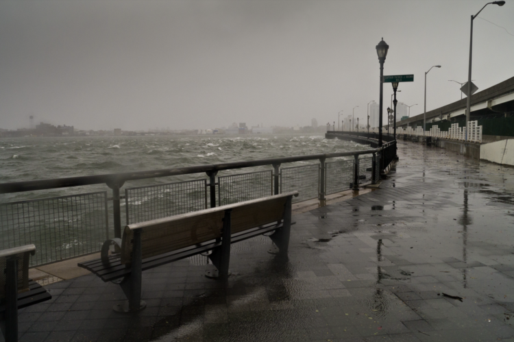
The wake-up call for New York came in 2012. On the night of 29 October, Hurricane Sandy drove a storm surge into the city’s low-lying neighbourhoods, flooding subway tunnels and streets, knocking out power and triggering an enormous fire in Queens that destroyed more than 100 homes. On Staten Island, dozens of people were killed. In Manhattan, thousands were evacuated, hospitals were shut and tunnels flooded. Few could have forecast the degree of devastation that Sandy would wreak on a metropolis with more than 800 kilometres of exposed coastline.
Enjoying this article? Check out our related reads…
More than a decade later, the storm still shapes the way New York thinks about its future. Hurricane Ida and Tropical Storm Henri, both of which struck in 2021, were further reminders that the city’s defences needed to be rebuilt for an age of more frequent extremes. That same summer also saw 17 days above 32°C, a sign of intensifying heat. Sea levels around New York have already risen about 30 centimetres since 1900 and could rise by a metre or more by the end of the century.
For many New Yorkers, however, climate adaptation is no longer an abstract future risk. It’s happening now, in parks, promenades, ferry terminals and marina slips – in the places where the city meets the water.
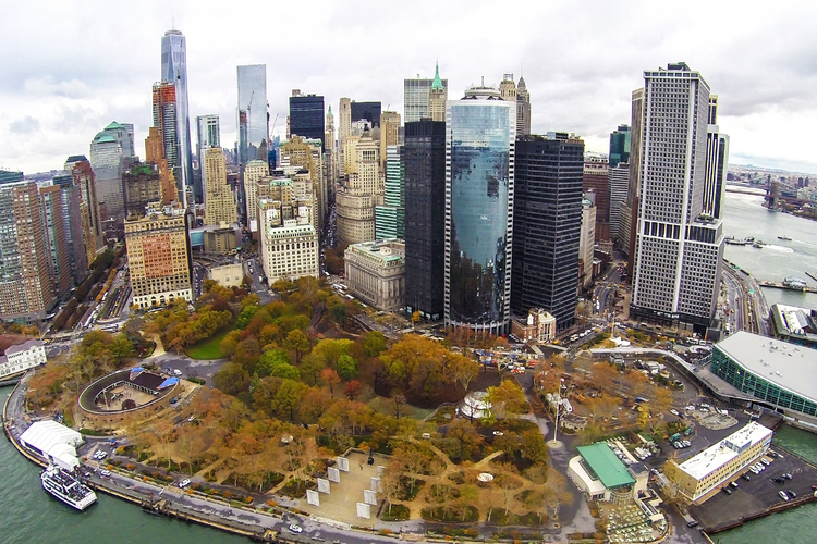
At the Battery, the southern tip of Manhattan, construction crews are rebuilding and elevating the wharf promenade as part of the Battery Coastal Resilience Project. The aim is to lift the waterfront edge above future sea-level-rise conditions while maintaining one of New York’s most symbolic public spaces. Nearby, in Battery Park City, Wagner Park – once loved for its open lawns and harbour views – has been rebuilt as part of a wider resilience scheme. Its new landscape sits higher, with flood protection incorporated beneath it. To supporters, it’s a glimpse of the resilient city to come. To some residents, it’s evidence that adaptation can arrive as disruption, replacing familiar places before the next disaster has even occurred.
This is the difficult politics of climate resilience. The question is not simply whether New York can defend itself from the sea, but how much of the existing waterfront it must remake in order to survive.
Paul Onyx Lozito, deputy executive director of the Mayor’s Office of Climate and Environmental Justice, is one of the officials involved in coordinating the city’s coastal-defence plans.
‘This is a generational issue for the city and we are taking an all-hands-on-deck approach,’ says Lozito. ‘Since 2007, we have been preparing for a significant rise in sea levels and the impact this is going to have on New York City’s communities. Our office plays a coordinating role in mapping out robust planning for this project in partnership with a constellation of city agency partners.’
The challenge is immense. New York is a city of islands, tunnels, ferry landings, subway stations, historic waterfronts, private property and ageing infrastructure. It has 42 islands and 850 kilometres of waterfront. The US Army Corps of Engineers has outlined a proposed multibillion-dollar plan to protect the wider New York metropolitan area from storm surges and coastal flooding, but the cost is daunting.
‘The city lacks sufficient financial resources to cover an outlay of funds of this magnitude,’ says Lozito.
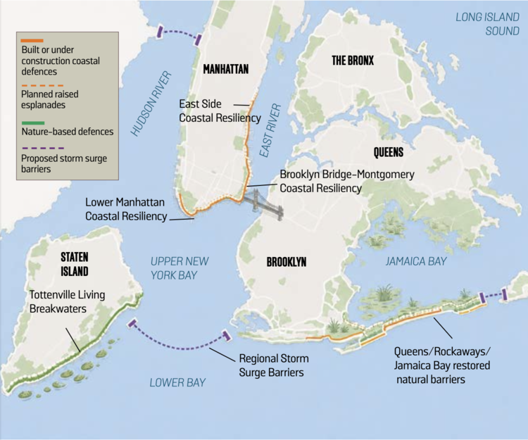
In Lower Manhattan, work is already advancing through the Lower Manhattan Coastal Resiliency strategy. The aim is to create a more continuous line of protection from Battery Park City, around The Battery and along the East River towards the Brooklyn Bridge and beyond. Some sections are under construction; others remain in design. The most complicated gap lies around the Financial District and South Street Seaport, where subway tunnels, ferry terminals, historic buildings and narrow waterfront spaces make conventional flood walls difficult.
Here, the proposed Financial District and Seaport Climate Resilience Plan would extend the shoreline into the East River, creating space for flood defences, drainage infrastructure, ferry facilities and new public open space. The plan imagines a multi-level waterfront: an upper level high enough to protect against severe coastal storms and a lower esplanade designed to maintain public access to the water.
In effect, New York would redraw part of Manhattan’s edge.
That ambition comes with trade-offs. Ferry terminals at Whitehall, Governors Island and Pier 11 are not just pieces of transport infrastructure; they are part of the everyday life of the city. Charter-boat operators at North Cove Marina have warned that long construction closures linked to resilience works could threaten their businesses, forcing them to search for scarce alternative berths. Public art has also become part of the argument. In Battery Park City, the long-standing Upper Room sculpture by Ned Smyth was demolished to make way for a tide gate, prompting anger from the artist and local preservationists. Adaptation, in other words, is not just a technical exercise – it has cultural costs.
Lozito says the city has been considering a variety of strategies to manage coastal risk, including special assessment districts and partnerships with the Army Corps. ‘Our office looks forward to presenting our work to the new federal administration and to continuing to refine that work in a contemporary way to meet the needs of flood-vulnerable residents,’ he says.
Those residents aren’t all in Lower Manhattan. Across New York, climate risk falls unevenly. Wealthier and more economically valuable districts often have stronger political and financial arguments for protection, while lower-income coastal neighbourhoods can find themselves waiting longer for defences. The debate over Lower Manhattan’s future therefore raises a wider question for the city: who gets protected first, and who is asked to live with risk?
The city is also trying to avoid building a blank wall between Manhattan and the water. Along the East River, the Financial District and Seaport plan seeks to support marine life as well as repel flood water. Project teams have studied currents, habitats and marine conditions, looking for ways to reduce ecological harm and create more varied surfaces for fish, crabs, clams, mussels, snails and other species. Green space on land could also connect habitat patches along the waterfront, drawing birds and pollinators.

Elsewhere in New York, a softer approach is already visible. Off Staten Island, the Living Breakwaters project uses artificial reefs to reduce wave energy and create habitat for oysters, crabs and fish. Such schemes can’t stop flooding on their own, but they point to a broader shift in thinking: coastal defence doesn’t always have to look like a wall.
In Manhattan, though, hard engineering remains unavoidable. Three flood-resilience projects come together around the Battery and must connect to create a closed protection system. The flood defence has to weave through a dense underground network that includes subway tunnels, the Battery Park Underpass and the Hugh L. Carey Tunnel. To avoid walling off the park from the harbour, parts of the protection will be buried beneath the landscape, creating a sloping landform rather than a visible barrier. Some areas may still be designed to flood safely during storms, while assets such as the SeaGlass Carousel, the Urban Farm and Battery Playscape are protected.
This is what makes the project so complex: New York is not simply defending a coastline; it’s defending a living city. Every new barrier touches a street, a view, a ferry route, a park bench, a business, a sculpture, a memory. The city has to build for waters that haven’t yet arrived while persuading people to accept changes to places they already know.
With federal funding uncertain, New York is looking for new ways to pay for shoreline protection before the next extreme weather event hits. In 2025, a city-convened task force of public and private experts produced a report titled Securing a Resilient New York City: Funding and Financing Shoreline Protection, which recommended a mix of new federal funding, local finance tools and engagement with insurers.

‘The city has and continues to explore bold funding plans to build infrastructure for a resilient future,’ says Lozito.
For now, Lower Manhattan remains both a test case as well as a warning. It’s one of the most valuable urban coastlines in the world, but also one of the most exposed. Sandy showed what happens when the sea enters the city. The harder lesson now is that defending New York from the next flood means changing the waterfront before it comes.