
• Skip to main content
  • Skip to secondary menu
  • Skip to primary sidebar
  • Skip to footer
Geographical

Geographical

Official magazine of the Royal Geographical Society (with IBG)

  • Geographical Home
  • News
  • Features
  • Opinion
    • Climatewatch
    • Front Lines
  • Podcast
  • Travel
    • Discovering Britain
    • Passport
  • Culture
    • Book reviews
  • Quizzes
    • Crosswords
  • Choose Geography
    • University directory
    • Masters courses
    • Course guides
      • Climate change
      • Environmental science
      • Human geography
      • Physical geography
    • University pages
      • Aberystwyth University
      • Brunel University
      • Cardiff University
      • University of Chester
      • Edge Hill University
      • The University of Edinburgh
      • Newcastle University
      • Nottingham Trent University
      • Oxford Brookes University
      • The University of Plymouth
      • Queen Mary University of London
    • Geography careers
      • Charity/non-profit
      • Education & research
      • Environment
      • Finance & consulting
      • Government and Local Government
    • Applications and advice
  • Magazine
    • Issue previews
    • Subscribe
    • Manage My Subscription
    • Special Editions
    • Geographical Archive
    • Advertise with us
  • Subscribe
    • Direct Debit Changes

Kelvin waves: the ocean phenomenon raising sea levels on the US West Coast

5 October 2026
3 minutes

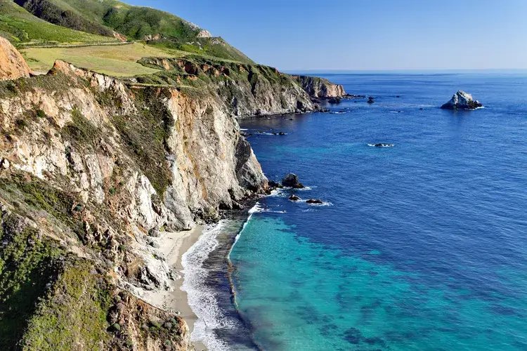
California coast
Kelvin waves occur beneath the ocean surface. Pictured above, the California coast. Image: Irina Sen/Shutterstock

This ocean phenomenon raises the sea level, and are common during El Niño events. This year’s super El Niño could make them even more intense


By Victoria Heath

This month, sea levels along the USA’s West Coast – particularly California – are expected to rise by up to 0.3 metres (one foot). This is due to an ocean phenomenon: Kelvin waves. But what exactly are they, and what impacts could they have?

Explaining Kelvin waves

Kelvin waves are extremely long ocean waves that propagate eastward toward the coast of South America. They cause the upper ocean layer of warm water to thicken, raising sea level.

They aren’t curling, crashing waves like those seen at a beach. Instead, they are a ‘disturbance inside the ocean’ – similar to waves in a bathtub, making slow, sloshing movements beneath the surface. While they don’t break, they still have peaks and valleys that change the water depth.

They have been happening for thousands of years, but because sea levels have been rising in recent years, the effects of Kelvin waves can be more pronounced.

Over the next week, the latest Kelvin wave surge will move along the California coast at a speed of around 241 kilometres (150 miles) per day, with experts predicting the waves will continue to pass through from October until February.

These waves, which can be up to hundreds of kilometres long, move at around five miles per hour. Importantly, they are not similar to tsunamis, which are instead caused by sudden movements like underwater earthquakes or landslides, and travel at hundreds of miles per hour.


Enjoying this article? Check out our related reads…

  • Geo Explainer: What is El Niño?
  • Geo explainer: What is a super El Niño?
  • El Nino 2023 – what can we expect?
  • Beware the return of El Niño
  • The coming El Niño could cost US$84 trillion

The increase in water levels caused by Kelvin waves is only temporary – lasting for several months at most – but can still cause impacts: added water levels can worsen coastal flooding and erosion if it overlaps with high tides, large surf or a coastal storm.

‘If you start with sea levels that are six inches higher than normal, when you have really high tides, big storms or storm surges, the water levels are now six inches higher,’ said research oceanographer with National Oceanic and Atmospheric Administration Fisheries’ Ecosystem Science Division Michael Jacox. ‘The effects can be amplified.’

El Niño and Kelvin waves

‘Kelvin waves are a symptom of El Niño,’ said Dillon Amaya, a professor at North Carolina State University. In a single El Niño year, up to six Kelvin waves can occur. This year, the first Kelvin wave moved up the coast in May and June.

Normally, trade winds push warm surface water westward across the equatorial Pacific. In an El Niño, these winds weaken or reverse, allowing warm water to move eastward and causing Kelvin waves to form deep in the Pacific Ocean.
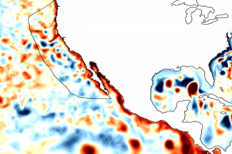
Coastally-trapped Kelvin waves, a signature of El Niño, traveled north along the West Coast during the 1997/1998 El Niño, as shown in a map of sea surface height anomalies. Darker reds show sea levels higher than normal, while darker blues show heights below normal. Scientists are now watching for similar waves to move up the West Coast this fal
Coastally-trapped Kelvin waves, a signature of El Niño, travelled north along the West Coast during the 1997/1998 El Niño, as shown in a map of sea surface height anomalies. Darker reds show sea levels higher than normal, while darker blues show heights below normal. Image: Dillon Amaya/North Carolina State University

This year’s El Niño is expected to be the largest in at least 1,000 years, meaning the Kelvin waves that accompany them could be more intense.

Higher tides also magnify the impact of storms, which are more likely in regions of the US during an El Niño. ‘Storms that peak during high tides are far more likely to cause damage than if the same storm peaked during low tide,’ said Kate Huckelbridge, executive director of the California Coastal Commission.

To prepare, California’s governor declared a state of emergency, placing road-closure and snow-removal equipment along highways. Emergency sand is also being placed on beaches as researchers worry that places such as Santa Cruz or Pacifica – with old sea walls – could be affected.

The California Coastal Commission has also encouraged homeowners and residents to prepare for any impacts by adding drainage and ensuring any damage to their properties is addressed in the event of severe weather.
Themes News Climate Ocean US

Protected by Copyscape

Primary Sidebar

SUBSCRIBE

GEOGRAPHICAL WEEKLY LOGO FREE - Sign up to get context, clarity and perspective in a noisy world, every Friday

Popular Now

November 2026 Geographical crossword

November 2026 Geographical crossword

Jim Morrison climbing towards the summit of Mount Everest

Skiing down Everest

European Union Blue Flags and Berlaymont Building, Headquarters of the European Commission.

EU announces new strategy for Arctic

Big Bend National Park

Trump administration asks Supreme Court to resume border wall project in national…

Families are facing flooding conditions in a displacement site in Baidoa.

More than 800,000 people at risk of displacement in Somalia due to…

Footer

  • Facebook
  • Instagram
  • LinkedIn
  • Reddit
  • TikTok
  • Twitter
  • YouTube

Geographical print magazine cover

Published in the UK since 1935, Geographical is the official magazine of the Royal Geographical Society (with IBG).

Informative, authoritative and educational, this site’s content covers a wide range of subject areas, including geography, culture, wildlife and exploration, illustrated with superb photography.

Click Here for SUBSCRIPTION details

Want to access Geographical on your tablet or smartphone? Press the Apple, Android or PC/Mac image below to download the app for your device

Footer Apple Footer Android Footer Mac-PC

More from Geographical

  • Subscriptions
  • Get our Newsletter
  • About Us
  • Contact Us
  • Advertise with us
  • Privacy policy
  • Terms & Conditions

Copyright © 2026 · Site by Syon Media