• Skip to main content
  • Skip to secondary menu
  • Skip to primary sidebar
  • Skip to footer
Geographical

Geographical

Official magazine of the Royal Geographical Society (with IBG)

  • Home
  • Briefing
  • Science & Environment
  • Climate
    • Climatewatch
  • Wildlife
  • Culture
  • Geopolitics
    • Geopolitical hotspots
  • Study Geography
    • University directory
    • Masters courses
    • Course guides
      • Climate change
      • Environmental science
      • Human geography
      • Physical geography
    • University pages
      • Aberystwyth University
      • Brunel University
      • Cardiff University
      • University of Chester
      • Edge Hill University
      • The University of Edinburgh
      • Newcastle University
      • Nottingham Trent University
      • Oxford Brookes University
      • The University of Plymouth
      • Queen Mary University of London
    • Geography careers
      • Charity/non-profit
      • Education & research
      • Environment
      • Finance & consulting
      • Government and Local Government
    • Applications and advice
  • Quizzes
  • Magazine
    • Issue previews
    • Subscribe
    • Manage My Subscription
    • Special Editions
    • Podcasts
    • Geographical Archive
    • Book reviews
    • Crosswords
    • Advertise with us
  • Subscribe

Global wildfires in 2024 destroyed an area larger than India

16 October 2025
3 minutes

Wildfires aerial
Human activity is responsible for between 80 and 90 per cent of wildfires. Image: Shutterstock

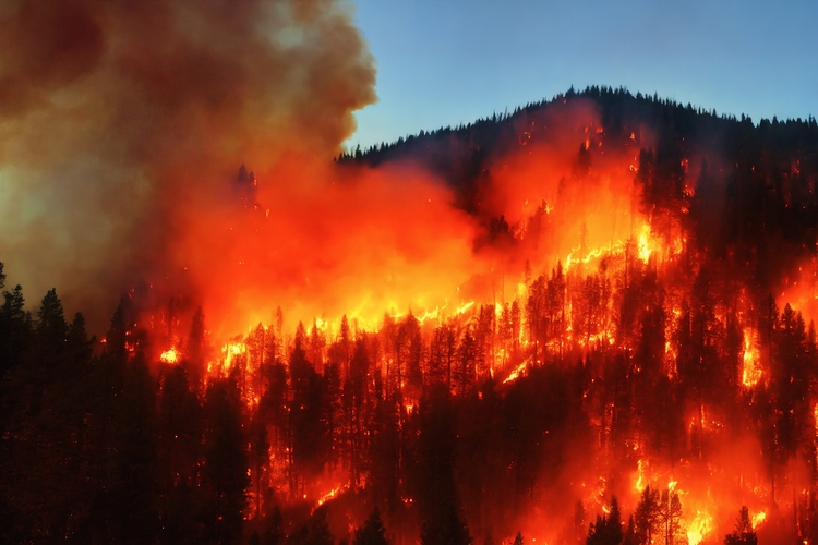
Extreme wildfires emitted more than eight billion tonnes of carbon dioxide during the 2024–2025 fire season


By Victoria Heath

Between March 2024 and February 2025, global wildfires burned through an area at least 3.7 million square kilometres in size – an area larger than India – according to research from a team of international scientists.

The figure marks a ten per cent decrease in the average annual area burned in the past two decades. However, due to an increase in wildfires occurring in carbon-rich forests, the CO2 emissions resulting from these fires were almost ten per cent above average.


Enjoying this article? Check out our related reads…

  • Geo explainer: Why are wildfires getting worse?
  • Are wildfires good for the environment?
  • Greece wildfires continue to spread across country
  • Geo explainer: The growing problem of UK wildfires
  • Canada wildfires continue to rage, affecting air quality in the USA

One study author explains that such a trend is indicative of a scenario in which we will experience ‘increasing extent and severity of fire in global forests, which are carbon-rich’, in comparison to fires in less carbon-rich grassland biomes.

The greatest increases in burned area and carbon emissions during the wildfire season were in Canada’s boreal forests, the‬‭ moist‬‭ tropical‬‭ forests‬‭ in‬‭ the Amazon region, the‬‭ Chiquitano‬‭ dry‬‭ forests‬‭ of‬‭ Bolivia and the Cerrado – a tropical savannah in central Brazil.

The latest report also highlights four of the most significant extreme wildfire events between 2024 and 2205: north-east Amazonia; South America’s Pantanal-Chiquitano region; the Congo basin and southern California.

According to their report, in some cases, the area burned by these fires was 25–35 times larger because of global warming.

What about individual countries?

In particular, North America was impacted by what researchers dubbed an ‘extreme’ fire year. Both total burned area and carbon emissions reached their second-highest levels since records began. Across the entire continent, the burned area was 35 per cent higher than the average, and carbon emissions were more than double the average figures.

In Canada, the wildfire season started early in 2024 due to a range of factors, from earlier than normal snowmelt to multiyear drought.

In the US, more than 64,000 individual wildfires burned through an area exceeding 36,000 square kilometres. More than 8,000 wildfires in Mexico led to 16,500 square kilometres of burned land.

Back in 2024, the US was also home to one of the most expensive wildfires ever recorded – those which broke out in Los Angeles. The two largest fires, named the Palisades fire and the Eaton fire, led to at least 30 deaths, the destruction of more than 11,500 homes and the evacuation of more than 153,000 people. Such fires resulted in estimated economic losses of $140billion.

The devastating fallout of two major blazes in LA. Video: NBC News

South America also experienced extremely high levels of wildfires during the 2024–2025 fire season. Collectively, wildfires burned through 120,000 square kilometres of land – 35 per cent higher than average – and contributed to the release of 263 megatons of carbon, the highest carbon emissions on record for the continent.

The scale of fires was well below average in Africa, excluding areas such as the Congo Basin, northern Angola and South Africa.

In 2024, a record high amount of land was burned by around 4,000 wildfires in the Congo Basin, a region famed for holding the world’s second-largest tropical rainforest. This burned area was 28 per cent higher than the annual average. Fires also led to ‘hazardous’ air pollution and led to the Congo Basin’s highest loss of primary forest in a decade.

Filed Under: Briefing Tagged With: Climate, Wildfires

Protected by Copyscape

Primary Sidebar

Subscribe to Geographical Magazine

Geographical subscriptions

GEOGRAPHICAL WEEKLY LOGOFREE - Sign up to get global stories, told well, straight to your inbox every Friday

Popular Now

Geographical Better World Video Awards Vote 2025

Geographical Better World Video Awards Vote 2025

Wildlife Photographer of the Year 2025 winner announced

Wildlife Photographer of the Year 2025 winner announced

QUIZ: Flags of the World – Europe

QUIZ: Flags of the World – Europe

A glacier calving

What happens when the world hits 2°C of warming?

Bleached coral

World’s first climate ‘tipping point’ reached as coral reefs experience dieback

Footer

  • Facebook
  • Instagram
  • LinkedIn
  • Reddit
  • TikTok
  • Twitter
  • YouTube

Geographical print magazine cover

Published in the UK since 1935, Geographical is the official magazine of the Royal Geographical Society (with IBG).

Informative, authoritative and educational, this site’s content covers a wide range of subject areas, including geography, culture, wildlife and exploration, illustrated with superb photography.

Click Here for SUBSCRIPTION details

Want to access Geographical on your tablet or smartphone? Press the Apple, Android or PC/Mac image below to download the app for your device

Footer Apple Footer Android Footer Mac-PC

More from Geographical

  • Subscriptions
  • Get our Newsletter
  • About Us
  • Contact Us
  • Advertise with us
  • Privacy policy
  • Terms & Conditions

Copyright © 2025 · Site by Syon Media