James Witlow Delano travels to Union Glacier to join scientists revealing how subtle shifts in ice and bedrock – and samples from ancient blue ice – are uncovering the planet’s climate future
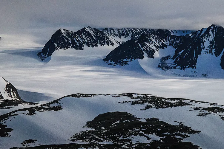
The Union Glacier – ten kilometres wide and 1,500 metres thick – sits at an elevation of 900 metres in the shadow of the Ellsworth Mountains, whose jagged peaks emerge from the great ice sheet like broken shards of glass. The wall of slow-moving ice (roughly 40 metres a year, compared with the world’s fastest-moving glacier, Jakobshavn Isbrae in Greenland, which moves at 40 metres a day) has pushed the sea back in what would be a vast fjord opening into Antarctica’s Weddell Sea.
Flying over the glacier in a Twin Otter aircraft, it’s possible to gaze south towards the pinnacles, where the West Antarctic Ice Sheet – a high plain of ice almost level with the tallest peaks – looms behind the mountain range, which acts as a natural dam holding it all back. Glaciers poke through the mountain passes descending from the polar plateau.

Since 2014, the Chilean Antarctic Institute and the Chilean Air Force have maintained the Union Glacier Joint Scientific Polar Station and its airstrip on the glacier from November through January, supporting scientists from around the world in their research.
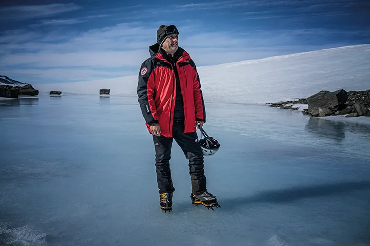
It gave me pause for thought when told we’d be sleeping for weeks in tents pitched directly on the glacier, at roughly 80°S latitude, where daytime highs, even in summer, barely reach –10°C.
On Union Glacier, it’s easy to forget the profound climatic changes taking place on the Antarctic Peninsula. Here, the temperatures mostly remain well below freezing, even in summer, but scientists are looking for telltale signs of climatic warming creeping in from the coast to this pristine interior.
The weather on the Antarctic Peninsula is far more capricous; violent gales can summon storms out of nowhere. Up on the glacier, the base is sheltered on all sides by high mountains and bathed, at least in summer, by gentle breezes beneath a sun that shines 24 hours a day. It was a pleasant surprise to find that the tents could be remarkably warm and comfortable.
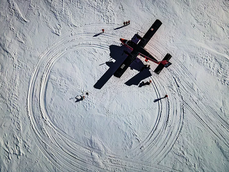
I joined the team on a flight to carry out some of their regular research tasks near the Ronne Ice Shelf. Coming in to land, the Chilean Air Force pilot rocked the Twin Otter back and forth to free the plane’s skis, which had frozen solid in their storage position. The mighty glaciers merge imperceptibly, creating a flat sea of ice stretching from horizon to horizon, broken only by the surrounding craggy peaks. The aircraft descended to the ice sheet, touched down but maintained velocity – testing for hidden crevasses – before lifting off again, looping around and executing a safe but bumpy landing.
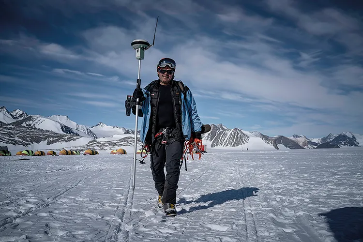
Ricardo Jaña, the base’s research chief, hopped out, propped a portable Global Navigation Satellite System (GNSS) receiver onto his shoulder, and purposefully high-stepped across the glacial ice towards a bamboo pole he had planted years before.
The pole moves with the glacier, allowing him to measure the vast glacier’s movement and thickness, and even the influence on it of tides, accurate to within less than a millimetre. To the north, a subtle dip marked the threshold where Union Glacier flows over the grounding line to join an amalgam of ice, fed by glaciers and ice rivers, forming the Ronne Ice Shelf. From the grounding line, an uninterrupted plain of floating ice, 150 metres thick, extends northwards for another 640 kilometres until it reaches the infamous iceberg-choked waters of the Weddell Sea, where Ernest Shackleton’s ship Endurance was trapped and crushed by sea ice in 1915.
After digging a small hole in the snow, Jaña lay flat, one hand steadying a measuring stick while the other used a scoop to extract a cube of snow. He deposited it into a pouch to take back to base to determine its density profile; a warmer climate makes snow denser and heavier. For 12 years, Jaña has been establishing baseline measurements so that future generations of glaciologists can accurately assess changes in the ice over time. His colleague, German Aguilera from the Chilean Military Geography Institute, told me: ‘Global warming is a silent pandemic. The glaciers that merge into Union Glacier may begin melting quite soon, a process that will not only reshape the glaciological landscape but also alter the region’s tectonic dynamics.’
He explained that as the weight of the ice is lifted from Antarctica’s bedrock by the thinning ice sheet, the bedrock could rise by up by as much as eight metres over the next century. Antarctica has lost three trillion tonnes of ice in the past 25 years – most of it from the West Antarctic Ice Sheet (WAIS). The bedrock beneath the WAIS, compressed by an even thicker ice sheet during the last ice age, is already beginning to rebound.

While Jaña monitors ice reactions to climate change, Aguilera and his colleague Angel Zapata use GNSS to track yearly coordinate differences, analysing changes and tectonic shifts around Union Glacier over the past 11 years. ‘Our GNSS measurements are crucial for monitoring shifts caused by glacial melt, providing valuable insights into the magnitude of its impact,’ Aguilera said. For glaciers, albedo typically exceeds 0.9, meaning more than 90 per cent of sunlight is reflected back into space, cooling the planet. But as the climate warms, many glaciers lose their protective winter snow cover, allowing black carbon from fossil fuel combustion to darken the ice surface, increasing heat absorption and accelerating melting. José Jorquera of the University of Santiago de Chile and Noe Vanalphen, a graduate student in environmental sciences at the University of Groningen in the Netherlands, launched a drone fitted with cameras to measure the blue ice’s albedo.
Frigid katabatic winds pulled down the Ellsworth Mountains’ face by gravity scour the glacier clean, turning Union Glacier into a ‘blue ice’ glacier – its wind-polished core so solid that massive aircraft such as the Ilyushin IL-76TD and the C-130 Hercules can land safely.
Raul Cordero of the University of Groningen explained: ‘We’re studying the deposition of heavy metals associated with energy-intensive activities and the growing Antarctic tourism industry. Sampling the blue ice surface along a horizontal transect, each sample provides insight into ancient atmospheric composition and past climate conditions.’

He added: ‘While reconstructing climate history typically requires deep vertical ice cores – time-consuming and costly – our surface sampling offers a valuable complement to traditional methods. This ancient ice has surfaced due to a combination of climatic factors, bedrock topography and upward ice flow.’
At the start of the season in November, advanced logistics crews survey the glacier on snowmobiles equipped with ground-penetrating radar attached to long poles, charting safe routes along Union Glacier and marking them with black-flagged bamboo poles to avoid potentially deadly crevasses hidden beneath fragile snow bridges. In 1990, a bulldozer pulling 16 tonnes of cargo fell through a snow bridge into a crevasse on the Ross Ice Shelf near McMurdo Station – miraculously without fatalities, but others haven’t been so lucky.
Enjoying this article? Check out some related ones…
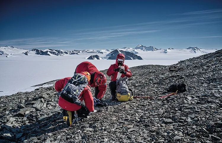
The logistics team, driving snowmobiles in single file with scientists riding pillion, followed one of these flagged routes to the foot of Escuela de Montaña, a flat-topped mountain with sweeping views over Union Glacier and its mountainous surroundings.
Dismounting, the team prepared to ascend, fitting crampons and grabbing ice axes. Acting as porters, they strapped on the components needed for a temporary weather station and transported them to the summit, where Professor Kenji Yoshikawa of the University of Alaska Fairbanks drilled into the rock to measure permafrost. Permafrost – rock or sediment that remains below freezing for two or more years – is a key climate indicator. ‘This is the southernmost permafrost borehole in the world,’ Yoshikawa said, leaning back into the drill as it slowly penetrated the cold-fractured rock.
‘The Antarctic interior is almost lifeless. Only a few scattered lichens on exposed rocks – and unseen microbes – survive in these harsh conditions.
‘There are long-term permafrost monitoring sites in Antarctica,’ Yoshikawa explained, ‘but all are coastal. None capture climate signals without direct ocean influence. Because Escuela de Montaña is the most accessible interior nunatak [a mountain poking through the ice sheet], it’s the best candidate for a long-term monitoring site. All we old guys can do is create data archives for future generations to analyse, as we did with limited 20th-century permafrost data.’
Monitoring is more than scientific curiosity – Yoshikawa advises construction firms worldwide on how to carry out building projects in permafrost zones, where thawing can compromise foundations.
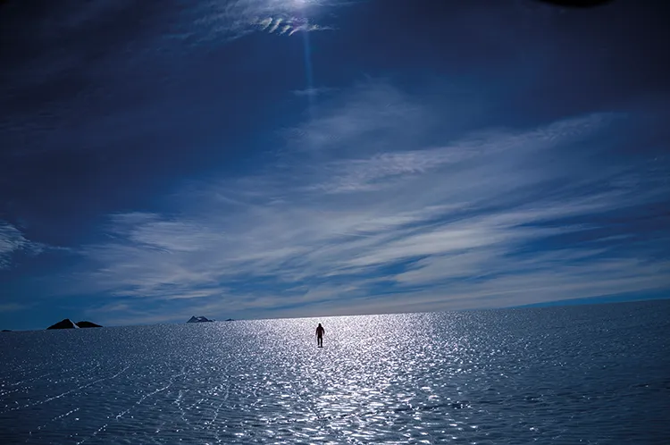
One clear afternoon, I joined Jaña as he skied, pulling a sledge of equipment, to collect GNSS measurements at points on Rossman Cove Glacier he had marked with bamboo in previous years. He paused, looking out across Union Glacier, where the sun made patches of blue ice shimmer. The ice and snow tapered from the sheer rocky flanks of the Ellsworth Mountains, reminiscent of sandy alluvial fans in the far warmer deserts you find near Las Vegas in the USA.
I remarked, ‘It must be hard to readjust to ordinary life back in Chile after this.’ Antarctica is like a 24/7 sensory overload – everything dialled up to 11.
A vast halo encircled the sun, hinting that snow was on the way. After a long pause, as if talking to himself, Jaña said, ‘Terrible, terrible.’ Then, turning to me, he said: ‘Antarctica is a symbolic continent. Our human activities are accelerating changes here because we demand more and more resources.’ The urgency in his voice was unmistakable. He added: ‘It’s the last chance for humanity to get it right.’


