Rory Walsh travels through time and space to a London landmark that shaped the world
Walk • Urban • Greater London • Web Guide
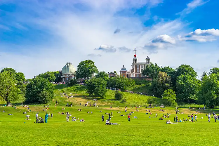
From a bench behind the National Maritime Museum, the slope of Greenwich Park rises like a cresting wave. Passing tourists chat in varied languages while, on the grass nearby, a local school group play football.
The children’s shouts and yells stop, then change when a small dog joins in. After a brief chase and a fastened lead, the match restarts. Without looking at my watch or phone, I know what time the pitch invasion occurred. On the horizon, another ball had moved.
Daily at 1pm (weather permitting), the Greenwich Time Ball drops at the Royal Observatory. Installed in 1833, today it’s mostly a visitor attraction, but it originally had a practical purpose.
Enjoying this article? Check out our related reads…
‘The time ball helped sailors to navigate,’ says Dr Louise Devoy, senior curator at the Royal Observatory Greenwich and author of Royal Observatory Greenwich: A History in Objects. ‘Ships would wait in the river and, when the ball fell, navigators could set their chronometers. Knowing the time accurately was vital for navigating at sea.’
Summer 2025 marks the Royal Observatory’s 350th anniversary. The Royal Observatory can seem small compared with other landmarks in the Maritime Greenwich UNESCO World Heritage site. Yet it has huge geographical significance.
As the home of Greenwich Mean Time and the Prime Meridian, the Royal Observatory shaped worldwide developments in navigation, timekeeping and astronomy.
Before reaching it, this walk begins near the Cutty Sark. On a flaming June day, the black masts pierce blue sky.
The route continues to the elegant façade of the Old Royal Naval College. Beyond the College’s Water Gate, the glistening River Thames bends past the O2 Arena. Reminders of Greenwich’s seafaring heritage recur throughout. Besides the National Maritime Museum, the walk passes statues of explorer Sir Walter Raleigh, Admiral Horatio Nelson and ‘the Sailor King’, William IV.
Greenwich was an important maritime site by the Tudor period. Its location, on a hill beside a Thames meander, provided a safe and deep natural harbour.
Viking longships anchored for more than three years and a small fishing village, Gronewic, was recorded in 918. Greenwich Park contains evidence of earlier settlements, including Bronze Age barrows and a Roman villa.
By 1300, the hill was royal land. King Henry VIII and Queen Elizabeth I were born in Greenwich, while explorers and sailors travelled through from around the world.
Worldwide travel encouraged another development. Enter King Charles II. ‘Charles II founded the Royal Observatory to solve a problem: calculating longitude at sea,’ Dr Devoy explains.
‘Longitude is the measurement of horizontal points on the Earth’s surface, east to west. Imagine the Earth as an orange, divided into segments. Each segment spans a geographical distance. As the Earth rotates – by 15° an hour – the segments also represent periods of time. Therefore, longitude can be determined by measuring the horizontal distance or time difference between two places.’

For centuries, both were difficult. During long sea journeys, clocks were affected by variations in temperature, pressure and movement. Navigating with the moon and stars, meanwhile, required great accuracy.
‘Longitude was a serious issue with practical significance,’ summarises Dr Devoy. ‘People were dying, ships were getting lost – with trade and military implications.’ On 4 March 1675, Charles II appointed John Flamsteed as astronomer royal. Flamsteed’s task was to create detailed star maps for navigators.
The Royal Observatory was established on 22 June 1675, with the foundation stone laid on 10 August. The building, known as Flamsteed House, stands on the site of Greenwich Castle.
From a balcony outside, Dr Devoy highlights its advantages: ‘First, the land was effectively free, with no purchase costs. There was little light pollution 350 years ago, as the area below us was open fields. This meant clear skies. The hill also provided a good view of the horizon, which helped astronomers trace transits – the movements of stars. Then there’s the river. The Thames was the motorway of the day – a quick and direct route to and from the observatory.’
Producing star charts was slow progress, however. In 1715, the British government passed the Longitude Act, which offered a £20,000 reward (almost £3.8 million today) to anyone who could find a solution.
The breakthrough came in the 1760s when John Harrison, a Yorkshire carpenter and clock maker, invented a reliable marine timekeeper that worked well at sea. By the 1820s, many ships had portable chronometers. A decade later, the Greenwich Time Ball was a sign that accurate timekeeping had become the major method of determining longitude.
From the balcony, Dr Devoy leads towards a gate below the time ball. We stop by a metal line that crosses the path: the Greenwich Meridian.
‘When calculating latitude – the Earth’s north– south axis – the Equator provides a shared reference point,’ Dr Devoy says. ‘Longitude, meanwhile, has no fixed references. Instead, astronomers use meridians – imaginary vertical lines that divide the east and west hemispheres of the Earth.’
The Greenwich Meridian was established in 1851 by the seventh astronomer royal, George Biddell Airy. Its course from North to South Pole passes through eight countries plus Antarctica, but mostly spans open sea. As the formal marker of zero degrees longitude, the Greenwich Meridian is the basis of Greenwich Mean Time (GMT). The sun crosses the line outside the Royal Observatory at midday GMT.

As we watch a steady stream of visitors take turns to stand on or beside the line, Dr Devoy reveals: ‘Greenwich actually has four meridians.’ I find this startling.
Dr Devoy explains: ‘Meridians have been used since the earliest days of astronomy. Different countries chose their own. The ancient Greeks used the Canary Islands, while the ancient Islamic meridian went through Jerusalem. The Greenwich Meridian moved gradually east due to improved telescopes and clocks. Ultimately, the lines are arbitrary.’
By the 19th century, practical (and political) requirement grew for a standard worldwide meridian.
In 1884, the International Meridian Conference decided the issue. There were four candidates – Greenwich, Paris, Berlin and the host, Washington DC. Greenwich was recommended and became the Prime Meridian. ‘It was a pragmatic decision,’ Dr Devoy reflects. ‘The spread of the British Empire meant most people and ships worldwide used Greenwich time already.’
Astronomers worked at Flamsteed House until 1957, when increasing light pollution saw the Royal Observatory move to Herstmonceux Castle in East Sussex. Flamsteed House is now an absorbing museum.
The view from it is still one of the best in London. Beyond the park, on opposite banks of the river, Greenwich’s stone domes and columns face the glass and steel towers of Canary Wharf. Dr Devoy comments: ‘They are both international trade environments, reliant upon accurate timekeeping.’
There are only a few metres between the Royal Observatory’s time ball and timeline. Yet walking between them recalls far longer journeys – from expeditions at sea to exploring the vastness of time and space. ‘Think big,’ Dr Devoy suggests. ‘Greenwich marks our distance to anyone, anywhere. It gives us all a common connection.’