See Ireland’s history, power struggles and evolving identity through these extraordinary maps
Charting centuries of Ireland’s past through cartography, Ireland: Mapping the Island by Joseph Brady and Paul Ferguson — a Hodges Figgis Book of the Year and An Post Irish Book Awards finalist — reveals the island’s history, power struggles and evolving identity through its extraordinary maps, and is published by Birlinn.
Erin, Hibernia Brittanicae Insulae nova descriptio, Abraham Ortelius (1592 Latin edition)
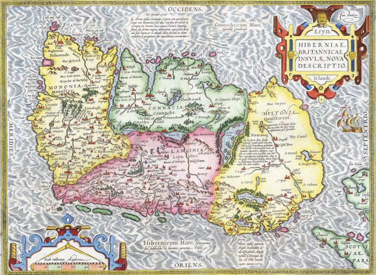
First published in 1573, this finely coloured map is among the earliest obtainable separate maps of
Ireland, based on Gerard Mercator’s 1564 map of the British Isles. Oriented with west at the top, it features decorative sailing ships and a coat of arms, and appeared in Ortelius’s Theatrum Orbis Terrarum, the first modern atlas of the world.
Civitates Orbis Terrarum, Georg Braun and Franz Hogenberg (1572–1617)
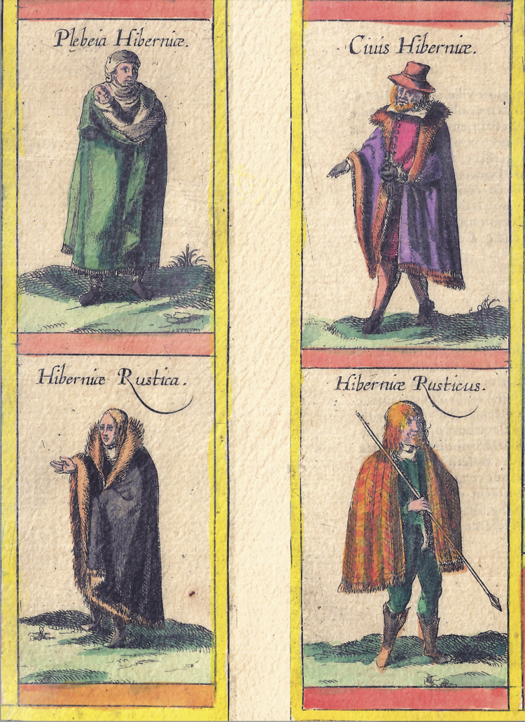
The ‘civil’ Irish and the ‘wild’ Irish juxtaposed, reflecting early-modern European stereotypes that contrasted urban, anglicised communities with those living beyond English control, which were often portrayed as untamed or barbarous.
Map of Leix and Offaly, unattributed, from the Hardiman Atlas, c. 1620
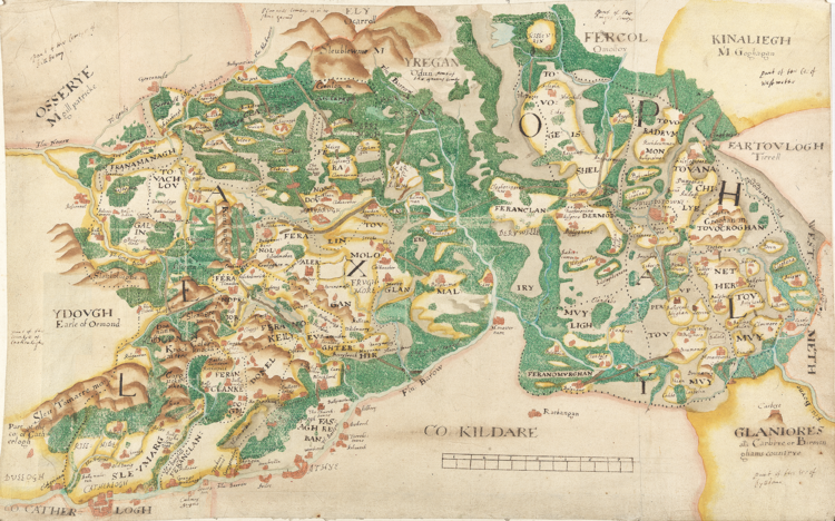
Showing the settlement patterns of the newly created plantation counties alongside the traditional lands of the local Irish population, this map depicts the towns of Maryborough and Philipstown, named for Queen Mary I and King Philip II, with Maryborough appearing the more heavily fortified within a volatile and contested landscape.
Map of the Irish Republic showing the result of the General Election, December 1918
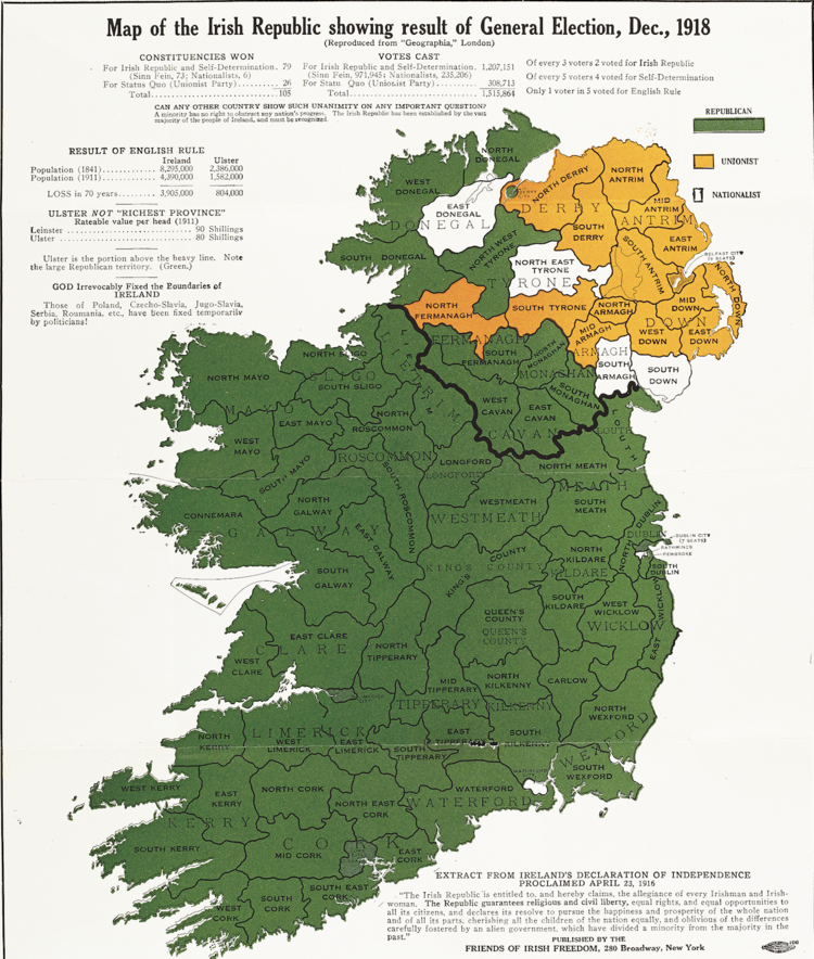
This is one variant of a map published in the USA by the Friends of Irish Freedom, a US-based organisation that mobilised public opinion against the partition of Ireland. Using election results to argue that partition defied the democratic will of the majority, the map formed part of a wider propaganda campaign aimed at influencing international, particularly American, opinion.
Ireland’s Right to Unity, cover of a booklet published by the All-Party Anti-Partition Conference, Mansion House, Dublin, 1949
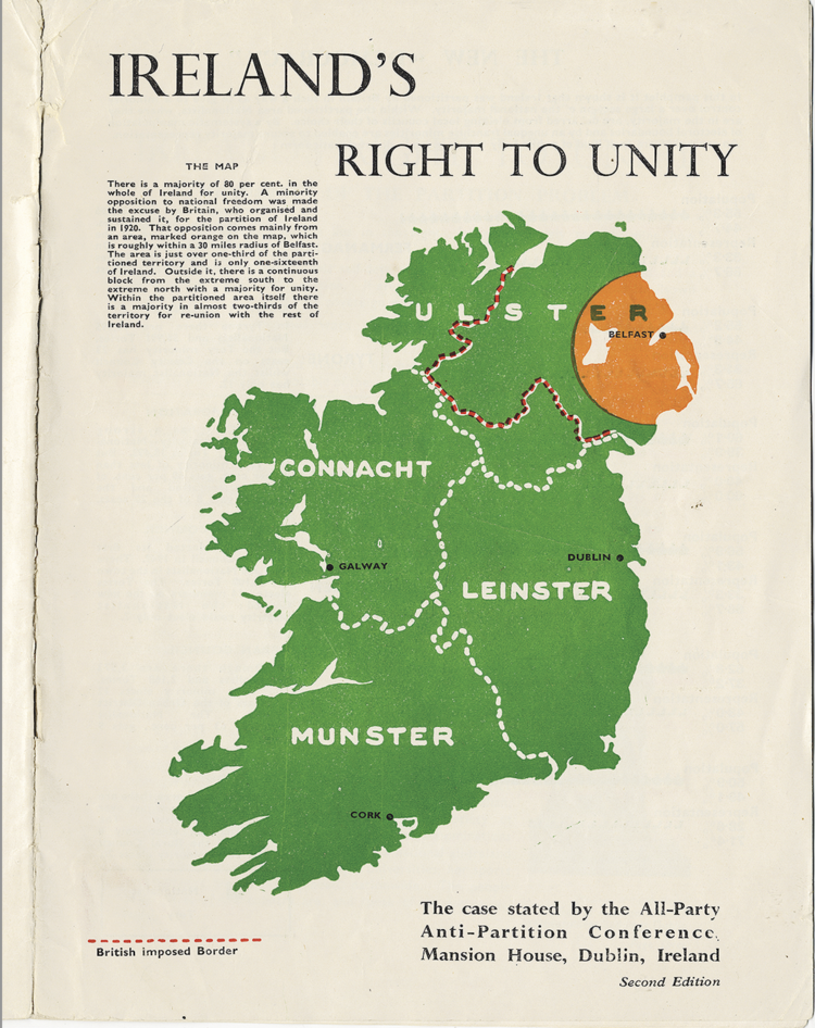
Produced at a time when partition had been legally entrenched for more than two decades, the booklet reflects a cross-party campaign to assert Ireland’s claim to unity and to challenge the continued division of the island through political advocacy and public persuasion.
Map of Partition in Ireland, advertising flyer for a conference held by the Anti-Partition of Ireland League in Birmingham, 29–31 January, 1949

The conference featured Éamon de Valera and the flyer reflects efforts by Irish political leaders and diaspora organisations in Britain to mobilise opposition to partition and sustain international pressure for Irish unity in the early years of the republic.
Ulster: A British Stronghold, cover of a four-page booklet outlining the strength of the Ulster economy and its contribution to the British Empire
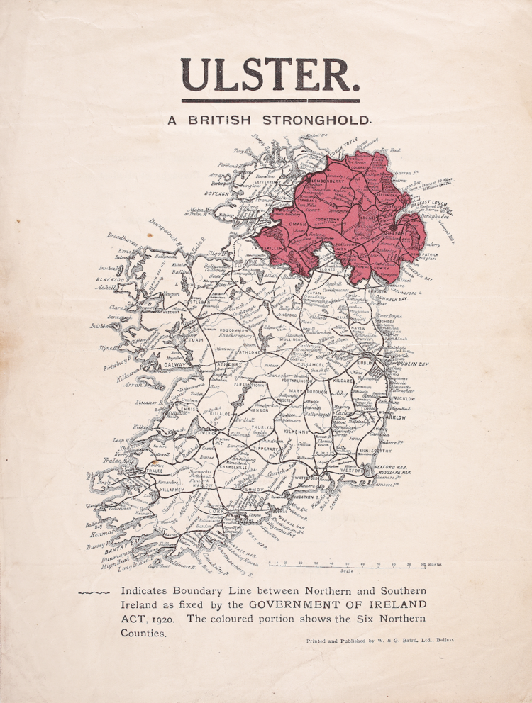
Printed by W & G Baird in the mid-1920s, the booklet reflects Unionist efforts to promote Northern Ireland’s economic viability and strategic value in the years following partition.
Blarney Castle. Ireland – Land of Romance, Great Southern Railways
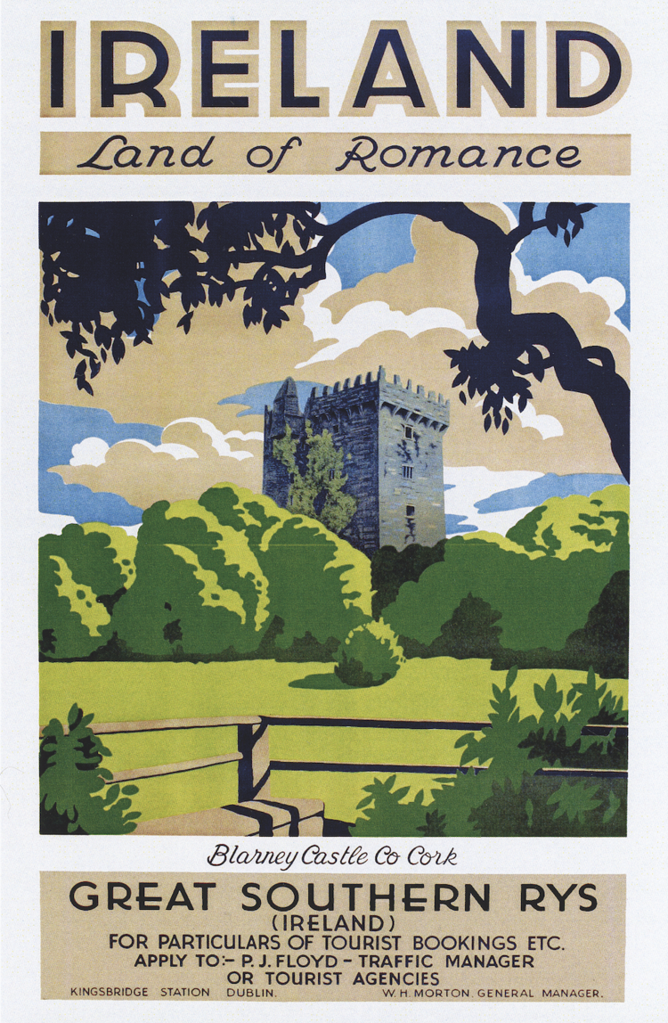
Produced during the golden age of travel posters in the 1930s, this image reflects how railway companies promoted Ireland as a romantic tourist destination, using iconic landscapes and heritage sites to attract visitors and encourage rail travel as a gateway to leisure and discovery.
Selection of Ordnance Survey maps
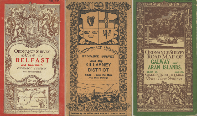
The Belfast map, printed in 1918, is at a scale of one inch to one mile. The Killarney map dates from 1913 and is at the same scale, while the map of Galway and the Aran Islands, dated 1921, is at a scale of half an inch to one mile, reflecting differing survey priorities and levels of detail.
Irish-Speaking Districts, 1871, EG Ravenstein (1879), from On the Celtic Languages in the British Isles: A Statistical Survey, Journal of the Statistical Society
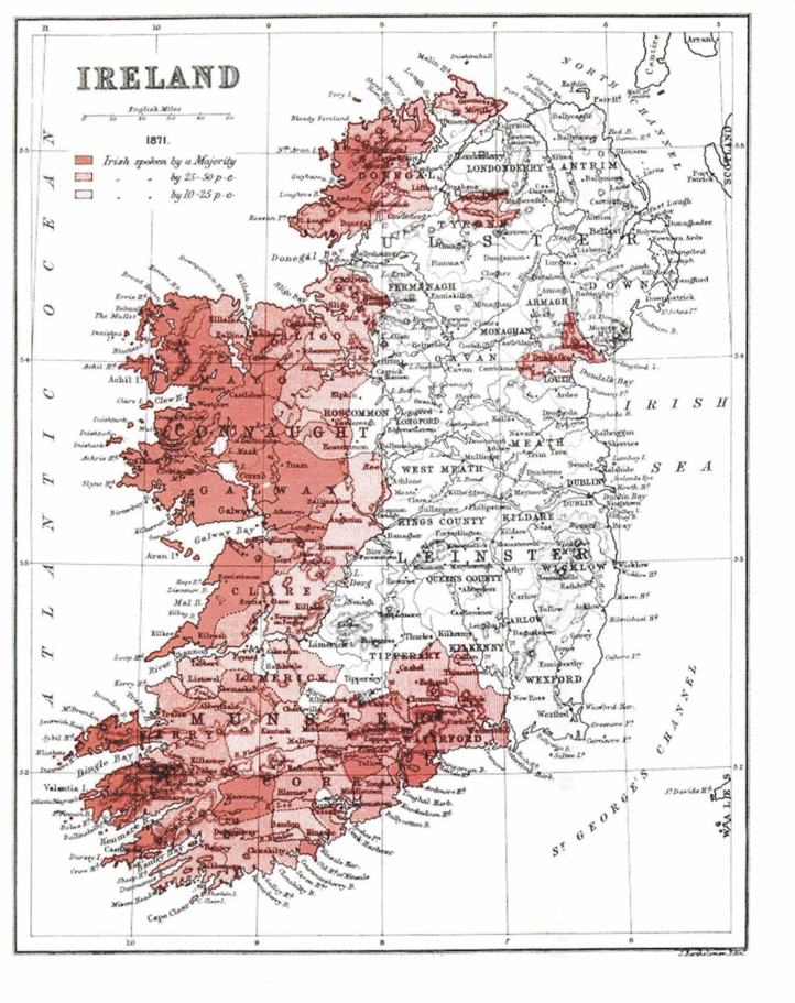
Based on the 1871 census, this map charts the geographical distribution of Irish speakers at barony level, showing the language increasingly concentrated in western districts and the decline of earlier eastern outliers, a pattern that Ravenstein correctly argued was likely to continue.
Cork. The Towne of Cork, unattributed, collected by Sir John Carew, early 17th century, from the Hardiman Atlas

While Cork had long been a Gaelic, and earlier a Hiberno-Norse, settlement, this town plan reflects how the town was re-presented through English administrative and military mapping during a period of consolidation and plantation.
Latest War Map of Europe as Seen through French Eyes: Map of Europe for 1870, Paul Hadol
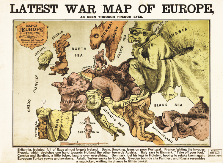
Drawing on the long tradition of personifying nations, this satirical map comments on European tensions on the eve of the Franco-Prussian War; Britain is shown as an isolated figure turned away from Europe, while Ireland appears as a cat on Britain’s leash, a visual metaphor for colonial control and subordination.
Ireland from Space, multi-temporal colour composite of land cover from the Sentinel-1A satellite, May 2015, European Space Agency

Created from 16 radar scans stitched together over a 12- day period, this image uses radar rather than visible light to overcome persistent cloud cover, revealing changes in land use, water and vegetation; blues indicate shifts in water bodies and agricultural activity, greens show vegetation change, and yellows highlight urban areas, with Dublin clearly visible.