New map will contribute towards understanding of marine ecosystems, coastal management and defence activities
By
When constructing renewable energy infrastructure, it’s vital that developers know the ground they’re working with. For offshore developments, detailed geospatial observations mean projects like submarine cables and wind turbines can be constructed without harming the environment.
This is certainly true in the Bristol Channel, an area attracting much interest for using its seabed for tidal power and wave energy.
Enjoying this article? Check out our related reads:
To support policymakers in the region, the British Geological Survey (BGS) has released an enhanced seabed geology map of the Bristol Channel, almost four times the size of the original, which extends from Carmarthen Bay to Newport and further south to the coast of Somerset.
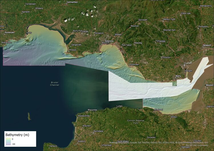
Beyond offshore infrastructure, this map also directly contributes to understanding of marine ecosystems, coastal management and defence activities. The data provides crucial information to those ensuring the port facilities along this coastline meet the requirements for these development opportunities.
As the UK transitions to renewable energy, such maps will become imperative to industry and stakeholders with an interest in developing clean energy.
‘The successful implementation of offshore renewable energy projects and technologies and the development of ports in South Wales require a detailed understanding of the seabed,’ said BGS Chief Geologist for Wales Rhian Kendall
‘This new, expanded, fine-scale seabed map of the Bristol Channel will be an invaluable resource for developers, providing access to high-quality, detailed observations of the seabed geology that is vital to these kinds of developments.’
The map, featuring combined bedrock, sediment, bedrock structure and seabed geomorphology data, is available from BGS under the fine-scale maps section of the Offshore GeoIndex and is designed to be viewed at 1:10 000 scale, or online as downloadable shapefiles.
Why is the Bristol Channel so important?
The Bristol Channel has long been touted as an area of national significance to meet the future demand for low carbon energy. It is the single largest resource area for tidal energy in the UK and has strong access to ports and grid connectivity.
However, considerations to environmental impacts must be made to avoid harming the plethora of wildlife and marine habitats within the region, as well as ensuring that its usage as a prominent shipping route can continue undisturbed.
Currently, there are no large-scale prominent projects taking place in the area, but many concepts are being explored: from building a tidal barrage or tidal lagoons to installing underwater turbines directly into the channel to capture tidal currents.