A new area equivalent in size to Sweden has been mapped in the Arctic Ocean, contributing to the project’s aim to map global seafloor by 2030
By
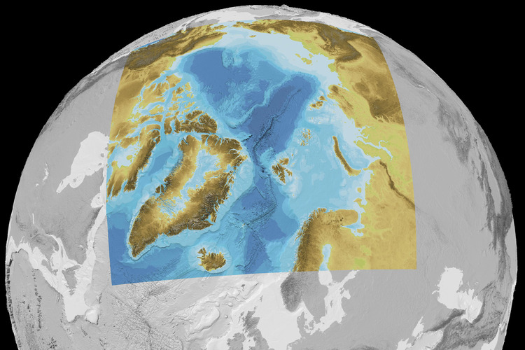
By 2030, a collaborative project aims to have entirely mapped the world’s seafloor. Launched in 2017, the initiative – known as Seabed 2030 – has now come closer to that goal, announcing a further portion of the Arctic Ocean has been mapped in a development published in Scientific Data by Nature.
Traditionally, perennial sea-ice cover along with extreme conditions has meant data collection in the Arctic Ocean is extremely limited, but now due to advancements in technology and advanced computing methods, scientists have been able to map this region in great detail.
This new area, released in the publication of the latest version of the International Bathymetric Chart of the Arctic Ocean (IBCAO), adds 1.4 million square kilometres of mapping coverage – an area over three times the size of Sweden – to the global seafloor dataset.
‘This release underscores the importance of regional initiatives like IBCAO in helping us achieve our goal of a fully mapped ocean floor by 2030,’ said Seabed 2030 Project Director Jamie McMichael-Phillips. ‘It represents a crucial step towards making essential data accessible for sustainable ocean management.’
So far, Seabed 2030 has managed to map around 25 per cent of the world’s ocean floor.
Enjoying this article? Check out our related reads:
Why is mapping the seafloor important?
The aim of high-resolution mapping, like the Seabed 2030 project, is beneficial in many ways: from ensuring the safety of marine activities – like ships passing through ocean waters, and underwater resource extraction – to monitoring how marine life and habitats change over time. The goal is ambitious, but as governments and other organisations collaborate together, it is hoped the project can be completed on time.
Currently, many navigational products rely on data recorded back in the 19th century, which used rowing boats with lines and lead weights. Updating this data will ensure that ships use routes that are safe for generations to come.
Mapping the seafloor also offers a great way to keep stock of ocean resources. For example, if resources like new medicines, rare metals and more are continually extracted before we can fully see their exact quantities, there is a real risk of depleting vital resources and permanently damaging the marine habitats that they reside in.
Another benefit of seafloor mapping is making global prediction models more accurate, such as those which forecast weather, climate and tsunami impact zones.
However, there is one significant problem that extensive mapping can cause, and that’s pollution – not just from fuels used by ocean vessels as they trawl through deep waters, but also undersea noise pollution that can impact communication between cetaceans and disorientate many species of marine life.
One way of solving this issue is to have autonomous vessels which could operate both without fossil fuels and without crew, as well as training local practitioners in data management, surveying and processing so that environmental damage can be lessened by data mapping.


