The US Army Corps of Engineers is locked in an ongoing battle of its own making – against the sea
By
The worst saltwater intrusion into the Mississippi River in decades is threatening to contaminate New Orleans’s major water supply. If the emergency measures currently being implemented do not succeed, this could leave nearly a million people searching for alternative sources of drinking water for several weeks in November.
Saltwater from the Gulf of Mexico can make its way upstream whenever the river flows drop below a certain level. The naturally occurring event is generally cyclical, with notable saltwater intrusions happening approximately once a decade in the region.
This year’s event is different, however, as it is the first time on record that an intrusion large enough for army intervention has occurred twice in consecutive years.
Usually, the US Army Corps of Engineers (USACE) quickly stem the flow of seawater by building a ‘sill’ – an underwater barrier. But this year, record temperatures and droughts in the region, structural damage along the riverbed, and rising sea levels have resulted in an unexpectedly large seawater wedge, which overshot the protective sill on 20 September.
What is a saltwater intrusion?
Usually, the seaward flow of a river prevents seawater from infiltrating freshwater. However, when river flow is slowed, saltwater begins to enter the river.
Because it has a higher density than freshwater, seawater forms a ‘wedge’ shape, which makes its way upstream along the bottom of the river. As it moves onwards, parts of the wedge mix with freshwater and make their way to the surface of the river.
Large saltwater intrusions occurred in the Mississippi River in 1988, 1999, 2012 and now in 2022 and 2023. So, why the sudden change of pace?
Riverbed dredging has worsened the risk of saltwater wedges
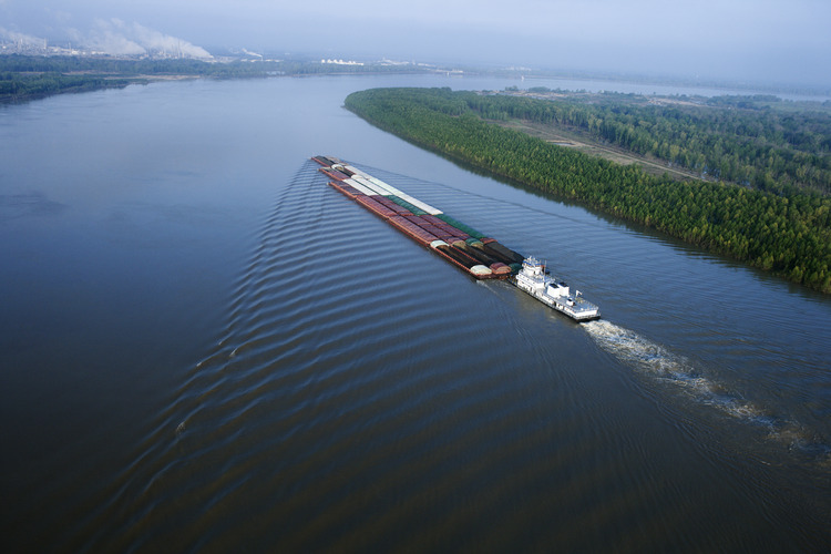
As noted by Bloomberg, the risk of saltwater entering the Mississippi has been exacerbated by almost a century of riverbed dredging by USACE. The federal agency delivers national infrastructure projects, such as the expansion of the Mississippi River Ship Channel. The route is a crucial part of the US’ maritime infrastructure – responsible for around 18 per cent of US waterborne commerce every year, according to a Corps report from 2018.
But a 2022 project to deepen the channel to around 15 metres (50 feet) to allow larger ships to pass through seems to have had more of an impact than anticipated. An assessment for the project found that ‘the municipal water supply for all of Plaquemines Parish (a downstream area of Louisiana) is put at risk for saltwater intrusion at the water intakes along the river during low water events’. But overall, the plan was ‘expected to have net positive environmental impacts’.
What will happen if the saltwater reaches New Orleans?
This week, USACE increased the height of the sill from 10m (35 feet) to 20m (60 feet). The sill and a slight increase in river flow have somewhat slowed the progression of the seawater wedge, according to the latest USACE update.
The wedge is now estimated to reach Belle Chasse by 27 October, two weeks later than initially expected. It is hoped that by the time the wedge reaches New Orleans’ water sources, the salinity of the water would have reached levels below the levels advised by the Environmental Protection Agency.
However, USACE has stepped up emergency plans in case conditions worsen. These include deploying a pop-up pipeline that transports freshwater to the city from further upstream and topping up freshwater reserves by barge delivery.
But this has not stopped the widespread anxiety spreading across the region, with many families continuing to panic buy bottled water.
Is this the new normal for Louisiana?
As droughts are expected to become more frequent and sea levels continue to rise in the changing climate, some scientific models suggest that saltwater intrusions will become an increasingly persistent problem in the Mississippi.
At the same time, long-term predictions of the effects of climate change by USACE researchers have shown that with increasingly heavy rainfall and stronger river flows, the likelihood of large saltwater wedges will reduce.
‘It’s still very much an open question what’s going to happen in the future of the Mississippi and the degree to which the trends we’ve been seeing over the last few years is the result of climate change,’ Samuel Muñoz, a hydrology expert at Northeastern University, told the Scientific American.


