• Skip to main content
  • Skip to secondary menu
  • Skip to primary sidebar
  • Skip to footer
Geographical

Geographical

Official magazine of the Royal Geographical Society (with IBG)

  • Home
  • Briefing
  • Science & Environment
  • Climate
    • Climatewatch
  • Wildlife
  • Culture
  • Geopolitics
    • Geopolitical hotspots
  • Study Geography
    • University directory
    • Masters courses
    • Course guides
      • Climate change
      • Environmental science
      • Human geography
      • Physical geography
    • University pages
      • University of Aberdeen
      • Aberystwyth University
      • Cardiff University
      • University of Chester
      • Edge Hill University
      • The University of Edinburgh
      • Oxford Brookes University
      • Queen Mary University of London
    • Geography careers
      • Charity/non-profit
      • Education & research
      • Environment
      • Finance & consulting
      • Government and Local Government
    • Applications and advice
  • Quizzes
  • Magazine
    • Issue previews
    • Subscribe
    • Manage My Subscription
    • Special Editions
    • Podcasts
    • Geographical Archive
    • Book reviews
    • Crosswords
    • Advertise with us
  • Subscribe

The Colorado River is running dry

28 December 2022
7 minutes

A boat stands on stilts on the dried out lake powell
Lake Powell is the second largest reservoir in the USA. In April last year, it dropped to 22.88 per cent of its water capacity, the lowest level since it was formed by damming the Colorado River in 1963

The Colorado River is running out of water, and it’s now listed as the most endangered major river in the USA


Words & photographs by Jonas Kako

The Colorado River snakes its way across the western USA for more than 2,000 kilometres – from the snow-capped peaks of the Rocky Mountains, down through stunning canyons, across deserts and over the border into Mexico. It’s the sixth longest river in the USA and flows through seven US states and two Mexican states. Its watershed spans eight per cent of continental America. With its tributaries, it’s the source of water for more than 40 million people. An economy worth US$1.4 trillion is dependent on its supply of water and the trade in boating, fishing, hiking and myriad other recreational activities alone is worth US$26 billion.

However, the mighty Colorado River is drying up. Today, it rarely reaches the ocean in the Gulf of California – the last time it did was in 1983. Climate change and an ever-growing demand for its precious water mean the NGO American Rivers now lists it as the most endangered major river in the USA.

Over the past century, a series of vast hydraulic-engineering projects based on a wildly over-optimistic estimate of the river’s flow skewed on three years of freak rain have fundamentally changed the river. Coupled with diminishing snowfall in the Rockies, extensive droughts, a rapidly growing population and large-scale intensive farming, this has meant that compared to 100 years ago, less than 20 per cent of the water that once flowed across the border now reaches Mexico.

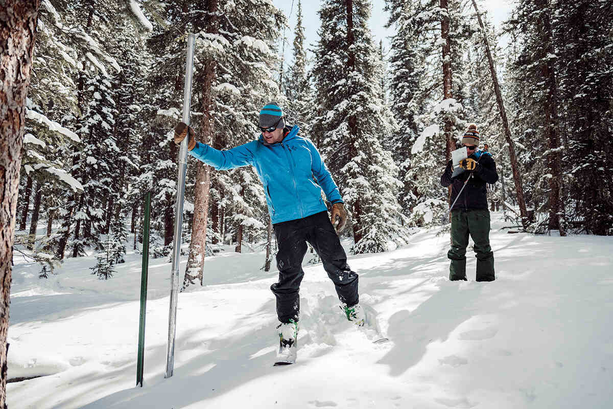
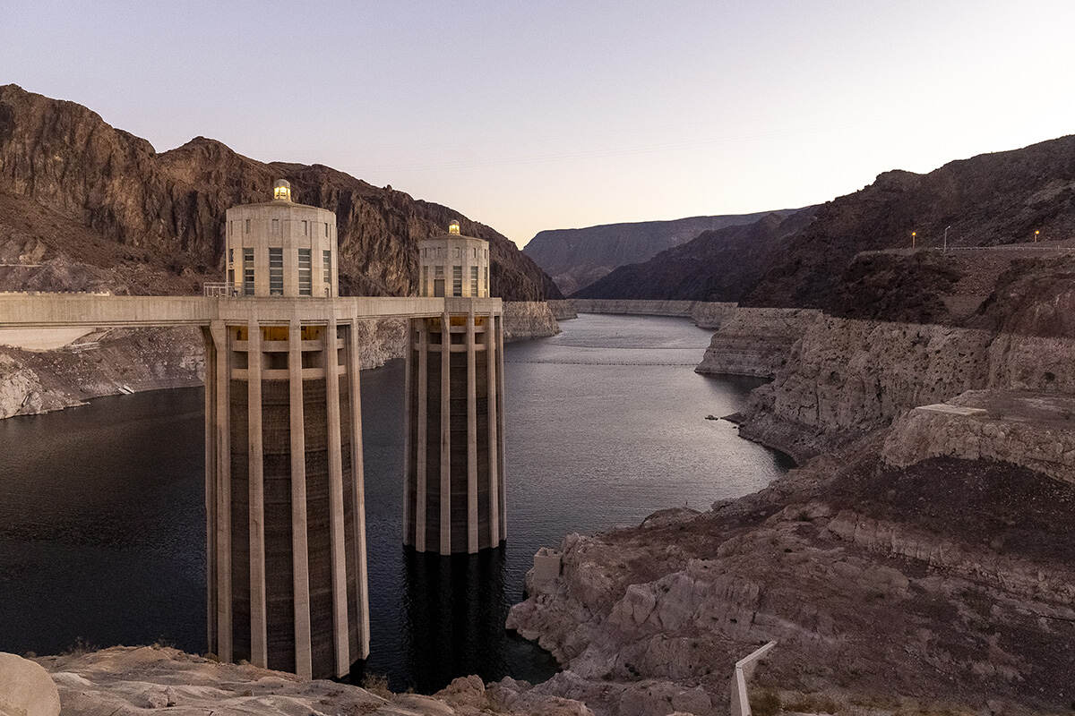
The falling water levels are clearly visible on the upper reaches of the river. The 450-kilometre segment that passes through the Grand Canyon is bracketed by the two largest storage impoundments in the USA – Lake Powell and Lake Mead. The Hoover Dam opened in 1935 and formed Lake Mead, now a shadow of its former self. Looking across the reservoir from Las Vegas, one can see the high water mark at a milky-white line along its shores. It has lost two-thirds of its volume and in a few years, water levels will be too low to drive the dam’s turbines to produce electricity. 

An aerial view of Horseshoe Bend
Horseshoe Bend is a 270° entrenched meander located eight kilometres downstream of Lake Powell near the town of Page in Arizona. On the left of the image you can clearly see the line marking the level that the Colorado River used to reach

In the spring of 2022, levels hit another record low, exposing one of the water pumps. Luckily, the water management company had installed a deeper pump
that was brought onstream just in time to avoid blackouts in Las Vegas. The booming desert resort is also dependent on water from Lake Mead – its 2.2 million population consumes more than double the average US per capita amount. 

In Las Vegas, there’s growing awareness of just how serious the lack of water has become. As of 2026, there will be a ban on the planting of natural lawn in the city and even today, there are tight restrictions on when and how much gardens and lawns can be watered. Repeat offenders can expect a hefty fine. Since the launch of the enforcement agency, some 16,000 infringements have been logged, 2,000 of which led to fines totalling half a million US dollars. 

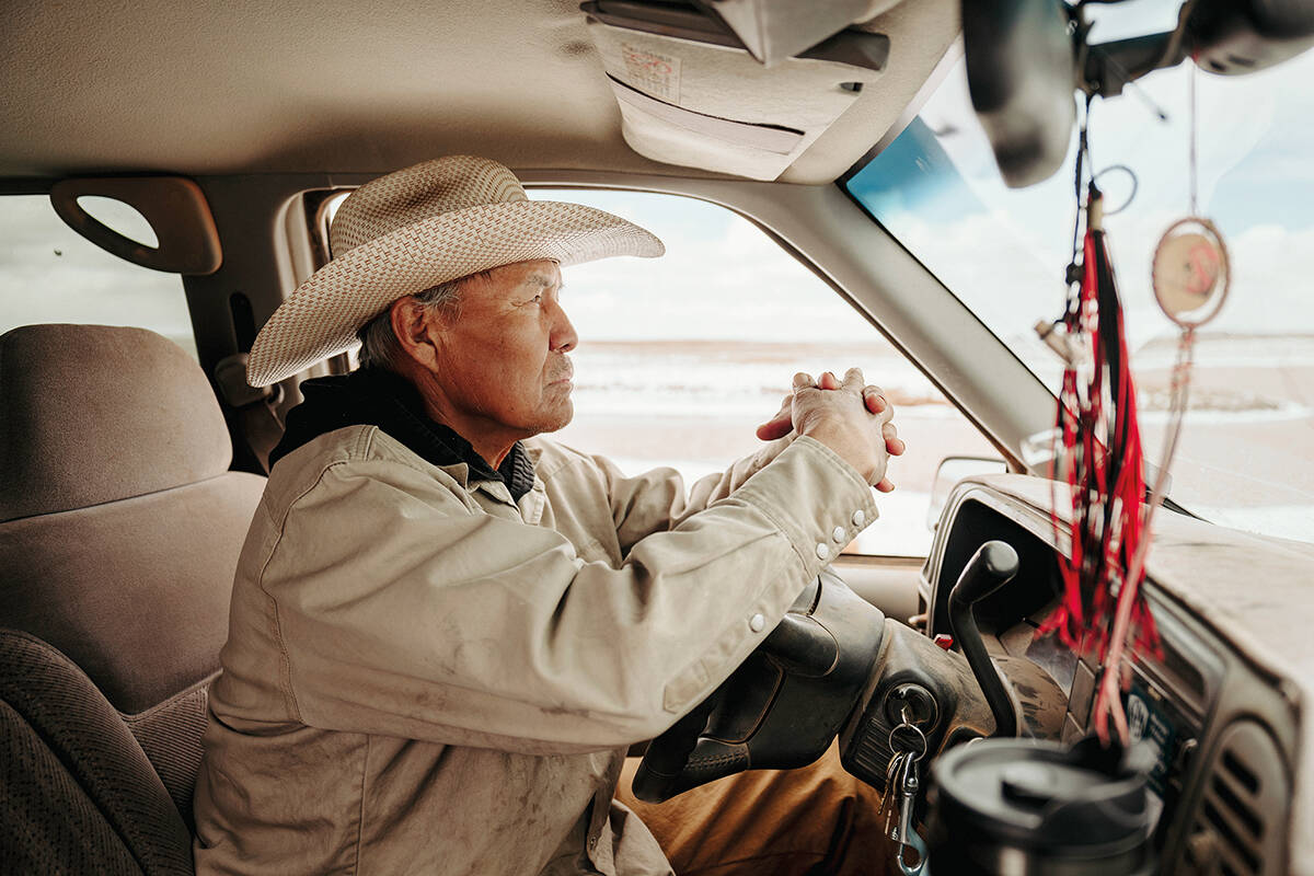
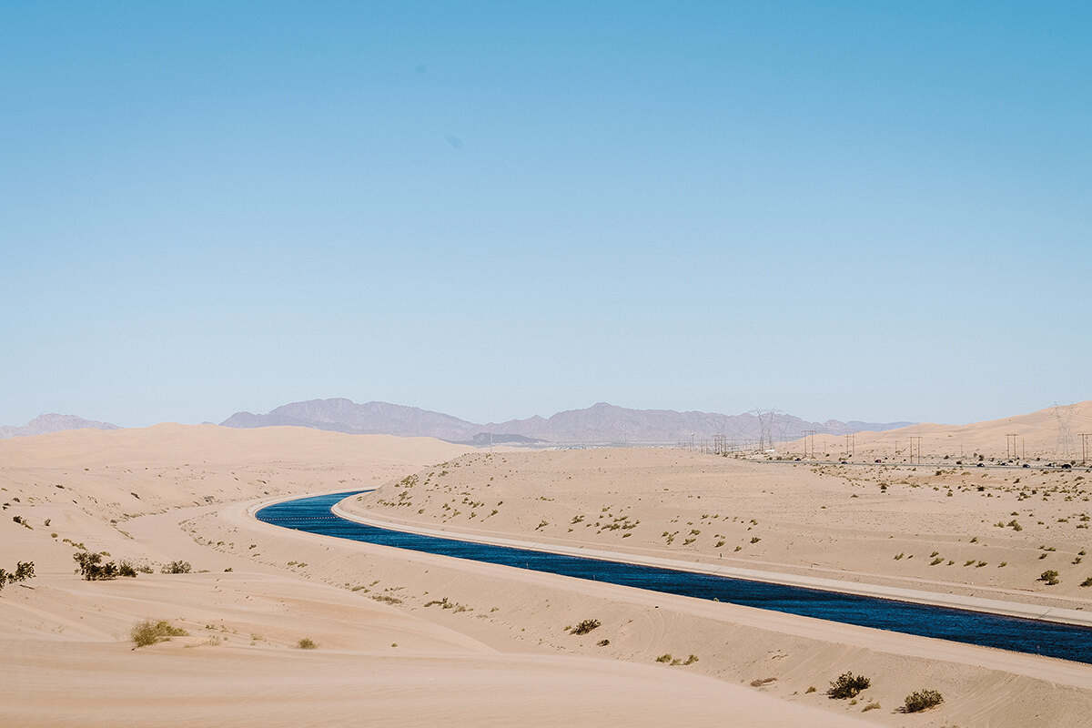
The water diversion to large conurbations such as Phoenix and Las Vegas has significantly lowered the river’s water levels and altered its course. However, the amount of water diverted for agricultural use in California and Arizona is causing the most controversy. Under a 1922 compact, the Colorado River US states were divided into an upper and a lower basin, each getting the right to roughly half of the river’s water. The upper basin is controlled by a system of state and local dams, while two federal dams manage water to the lower basin: the Hoover Dam outside of Las Vegas and the Glen Canyon Dam on the Arizona–Utah border. However, California and Arizona have consistently taken more than their agreed share. This is due to come to a head soon because of a more recent agreement that stated that California would have to start reducing its take from the river if the water level in Lake Mead drops below 318.45 metres (1,045 feet), which it’s expected to do this month. Currently, the states are trying to negotiate an agreed share of the river’s diminishing waters.

A farmer rides a horse in a field with a rope in his hand, surrounded by cows to catch
Dean VanWinkle, a fifth-generation farmer, catches newborn calves to be tagged and vaccinated on the family’s mountain ranch. Raising cattle has become expensive due to the lack of water. In 2021, the family had to sell 100 of their cows early because their own hayfields only produced about 60 per cent of their needs due to drought

‘You can’t possibly overestimate how hard this is,’ said Felicia Marcus, a fellow at Stanford University’s Water in the West programme and former chair of the California State Water Resources Control Board. ‘Each state has their own peculiar set of politics.’

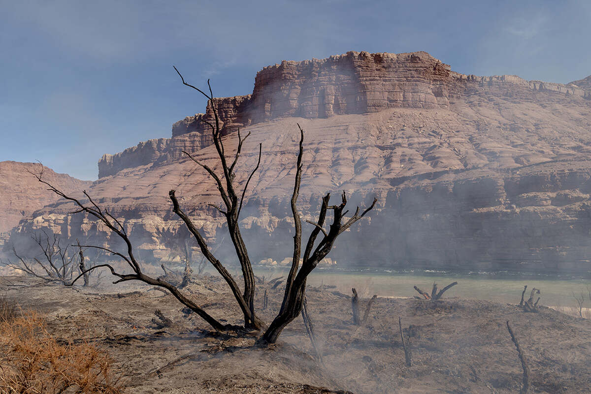
Once you get to the mouth of the river in the Gulf of California, there’s little trace of the once mighty waterway. What used to be a broad delta that saw waves of migrating birds enjoying its rich ecosystem is now a salty desert. The sea is encroaching on the delta, driving back flora and fauna not adapted to high salinity levels. 


Some other water related stories to enjoy

  • Ocean photography reveals the power and mystery behind the waves
  • The extraordinary world of plankton
  • How illegally caught fish in the Mediterranean enter Europe
  • Walking on water via one of London’s hidden rivers
  • The Ganges: river of life, religion and pollution

According to a recent study published in Science, climate change is the main cause of the Colorado’s decline. Chris Milly and Krista A Dunne, the study’s authors, calculated that the river’s levels were down by some 1.5 billion cubic metres of water, roughly the annual water usage of ten million Americans. 

The water cycle is caught in a vicious circle. Less snowfall in the Rockies, caused by climate change, leads to less sunshine being deflected back into the atmosphere, which in turn causes the ground to warm more quickly and water to evaporate more rapidly. Ultimately, this means that less water ends up in the reservoirs. 

According to Milly and Dunne, every degree of warming in the region causes the volume of water flowing through the Colorado River to shrink by some 9.3 per cent. 

Two men standing in a snowy forest measuring the depth of the snow
Brian Domonkos (at left) and Tristan Amaral of the USDA Natural Resources Conservation Service measure snow depth in the Colorado Rocky Mountains. The regular surveys provide important data about river flows further downstream
Smoke rises from the remains of burnt tamarisk trees with a mountain in the background
Smoke rises from the charred remains of invasive tamarisk trees following a controlled fire on the banks of the river in Utah. In order to limit the spread of the trees, which have a high water requirement, and to make room for native plants, the National Park Service regularly sets them on fire
A couple sit in a gondola on the water at the venetian hotel in vegas
A couple takes a gondola ride in the canals of the Venetian Hotel & Casino on the Las Vegas Strip. The Colorado River supplies ninety per cent of the city’s water needs
Hoover dam and Lake Mead
The Hoover Dam’s inflow towers sit exposed in Lake Mead. At the highest water level, they would be almost completely underwater. The water level in Lake Mead, the largest reservoir in the USA, has dropped significantly. The last time it filled to capacity was 2000 – since then, it has dropped each year, with the exception of the winter of 2010–11. In June 2021, it fell to the lowest level since it was first filled in 1941
A man sits in a truck looking out at the water levels
Leonard Sloan checks the water level of a stormwater storage pond on rangeland near the Grand Canyon on the Navajo Reservation. In just a few more weeks, the water will be used up by free-grazing cattle and sheep, at which point he will have to start trucking in water for his animals every week
The dark blue all american canal cutting through the colorado desert
The All-American Canal and two other smaller canals in the Lower Colorado River Valley divert 90 per cent of the river’s flow to 200,000 hectares of farmland in neighbouring Imperial Valley in California, which is one of the most productive winter-agriculture areas in the USA
Two people on a boat check fish in nets
Tiffany Love Chezem (left, below) and Pilar Rinker of the US Fish and Wildlife Service catch razorback sucker on Lake Mohave, a reservoir on the river. The fish are threatened by habitat loss. After they’re caught, the fish’s ages are checked and then they’re released
An aerial view of the vast Sonoran Desert
Since the 1980s, water from the Colorado River no longer reaches the Gulf of California, instead drying up in the Sonoran Desert
A woman on a boat on a river holds onto a fishing net
Leticia Galavis Sainz pulls her fishing net from the water in a highly polluted stretch of the river that passes through her tribe’s reservation in the desert in Mexico. The Colorado’s delta in the Sonoran Desert has mostly dried up and the remaining waterways are polluted with agricultural run-off, with few fish now surviving.
A man holds a slate with bees and stands over bee hives
Alfredo Fierro tends bees vital for crop pollination in the desert near Wenden, Arizona. A reduction in rainfall has meant that for several years, he has had to provide drinking water for the bees in troughs
A shirtless man sits drinking a beer on the bed of a truck
Jesus Colunga sits on the banks of the dry river in Mexico near the US border. In his youth, he often swam here. Today, the water is diverted to canals for agriculture and to supply major US cities such as Los Angeles and Phoenix

Filed Under: Science & Environment Tagged With: Climate, January 23, Water

Protected by Copyscape

Primary Sidebar

Subscribe to Geographical Magazine from just £4.99

Geographical subscriptions

Sign up to our newsletter and get the best of Geographical direct to your inbox

Popular Now

July 2025 Geographical crossword

July 2025 Geographical crossword

Out now: July 2025’s Geographical Magazine

Out now: July 2025’s Geographical Magazine

Ocean waves produce two to three times the world’s total energy needs

How to harness the waves: from halting tsunamis to clean energy

QUIZ: Landforms

QUIZ: Landforms

Kewang member in the Haruku forest, Indonesia

Better World Video Awards 2025 – Kewang: Nature’s Ancient Guardians

Footer

  • Facebook
  • Instagram
  • LinkedIn
  • Reddit
  • TikTok
  • Twitter
  • YouTube

Geographical print magazine cover

Published in the UK since 1935, Geographical is the official magazine of the Royal Geographical Society (with IBG).

Informative, authoritative and educational, this site’s content covers a wide range of subject areas, including geography, culture, wildlife and exploration, illustrated with superb photography.

Click Here for SUBSCRIPTION details

Want to access Geographical on your tablet or smartphone? Press the Apple, Android or PC/Mac image below to download the app for your device

Footer Apple Footer Android Footer Mac-PC

More from Geographical

  • Subscriptions
  • Get our Newsletter
  • About Us
  • Contact Us
  • Advertise with us
  • Privacy policy
  • Terms & Conditions

Copyright © 2025 · Site by Syon Media