Tsunamis can be devastating for coastal communities, particularly when they hit without warning. So how do scientists detect them in good time?
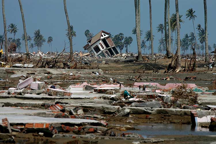
On 26th December 2004, a tsunami in the Indian Ocean, triggered by an underwater earthquake reached 30 metres in height as it roared towards the coast. The waters devastated parts of Indonesia, Sri Lanka, the Maldives, Thailand, and other places, and its effect was seen as far away as South Africa. More than 230,000 lives were lost and many more people remain missing to this day.
Crucially, the lack of any warning system meant people were caught entirely by surprise, a fact which undoubtedly contributed to the death toll. Since that disaster, systems for detecting tsunamis and warning coastal communities about them have significantly improved, although research is constantly evolving. We explore some of these systems below.
What is a tsunami?
The word ‘Tsunami’ comes from the Japanese characters for harbour (tsu) and wave (name).
Although they may conjure an image of one gigantic wave towering over tall buildings, a tsunami is actually a series of extremely long waves (multiple waves tens-to-hundreds of miles between crests) caused by a large and sudden displacement of the ocean. These waves are often referred to as the tsunami wave train.
These waves begin in the deep ocean where they may be barely noticeable. At this point they are rarely more than a metre high. As they reach shore, however, they slow down, their wavelengths decrease, they grow in height, and currents intensify. When they strike land, most tsunamis are less than three metres high, but in extreme cases, can exceed 30 metres when they strike near their source.
In the deep ocean, tsunamis can move over 500 mph, and can cross entire oceans in less than a day. As the waves enter shallow water near land, they slow to approximately 20 or 30 mph.
According to the Global Historical Tsunami Database, tsunamis that cause damage or deaths near their source occur approximately twice per year. Tsunamis that cause damage or deaths on distant shores (more than 1,000 kilometres away) occur about twice per decade.

What causes a tsunami?
Most tsunamis are caused by earthquakes which displace the ocean, although other events can also displace the ocean and result in a tsunami, including landslides, volcanic activity, certain types of weather, and near earth objects such as asteroids and comets.
Most tsunamis are generated by earthquakes with magnitudes over 7.0 that occur under or very near the ocean and less than 100 kilometres below the Earth’s surface. They must be big enough and close enough to the ocean floor to cause it to move vertically, either rising or dropping. When this happens, the water above also moves up and down causing the tsunami to radiate out in all directions.
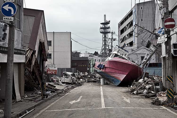
When a tsunami reaches the coast it doesn’t necessarily present as a giant wave, in fact tsunamis rarely become great towering breaking waves. It may look like a fast-rising flood, or a wall of water (bore). Sometimes, before the water rushes on land, it will suddenly recede.
Where do tsunamis occur?
Of the 754 confirmed events in the Global Historical Tsunami Database between 1900 and 2015, about 78% occurred in the Pacific Ocean (around the geologically active area known as the ‘Ring of Fire‘), 8% in the Atlantic Ocean and Caribbean Sea, 6% in the Mediterranean Sea, 5% in the Indian Ocean, and 1% in other seas.
Since 1900, the highest percentage of tsunamis was generated off Japan (21%) followed by Russia (8%) and Indonesia (8%).
How are tsunamis detected?
Tsunamis are detected via a combination of seismic data from earthquakes and a water-based system of buoys.
Usually, the earthquake is the first warning sign of a tsunami. Seismic waves travel about 100 times faster than waves of water, so information about an earthquake is available before information about any tsunami it may have generated.
A series of Seismic Networks around the globe are in place to detect earthquakes on land and at sea. When an earthquake occurs, these networks provide information about its location, depth, magnitude, and other characteristics. Warning centres analyse this information to determine if the earthquake could have generated a tsunami.
Several nations operate these warning centres. For example, the US National Weather Service operates two Tsunami Warning Centres, which are staffed 24 hours a day, 7 days a week.
If an earthquake meets certain criteria, the warning centres turn to water-level information, looking for changes in water-level height that could indicate the existence and size of a tsunami. The primary sources of information about water-level change are a network of systems called DART (Deep-ocean Assessment and Reporting of Tsunami (DART) systems) and an extensive array of coastal water-level stations.
The DART systems were developed by NOAA (National Oceanic and Atmospheric Administration) in 2008, four years after the devastating 2004 tsunami. The US network is composed of 39 systems which are strategically located throughout the Pacific and Atlantic Oceans, the Gulf of Mexico, and the Caribbean Sea. These links to a wider international system.
According to NOAA, each DART system consists of a bottom pressure recorder (BPR) anchored on the ocean floor and a separately moored companion surface buoy. When a tsunami passes over a BPR, the instrument detects and records the changes in the overlying water pressure. An acoustic link transmits information from the BPR to the surface buoy, which then relays it via satellite to the warning centres where the information is incorporated into tsunami forecast models.
Tsunami forecast models are numerical models which use the real-time information and pre-established scenarios to simulate tsunami movement across the ocean and estimate coastal impacts. The resulting forecasts help the warning centres decide if they should issue warning messages (or cancellation messages if previous warnings were sent but have been proved inaccurate).

Are there better ways to detect tsunamis?
DART systems have improved tsunami detection, but they’re not perfect. When triggered, a tsunami can hit the coast within minutes. Even in the best case scenario it is usually only an hour or two. DART systems require the tsunami to physically reach the measurement location and these are limited. Installing the buoys in the deep ocean for example would require an unrealistic number. This means that even if a tsunami is detected accurately it might not leave a coastal community with enough time to prepare.
As a result, researchers are working on other, complimentary systems. At Cardiff University, researchers propose using acoustic gravity waves — low-frequency pulses generated by the up-and-down movement of sea water caused by earthquakes and other events. Though slower than seismic waves, acoustic gravity waves move through the water about 10 times faster than a tsunami, and could therefore offer an early alarm.
They can be detected by underwater microphones known as hydrophones, many of which are already deployed around the world. The researchers propose extending the surveillance capabilities of hydrophones to listen for signs of tsunamis. Algorithms would then be used to the classify the preceding earthquake’s slip type and magnitude before calculating other earthquake properties like length and width, uplift speed, and duration to reveal the size of the tsunami.
A different proposal by NASA involves utilising GPS signals. In 2023 NASA scientists introduced an experimental system called GUARDIAN (GNSS Upper Atmospheric Real-time Disaster Information and Alert Network). The system taps into data from clusters of GPS and other wayfinding satellites orbiting our planet. The radio signals from these satellites travel to hundreds of ground stations around the world and the new system sifts the signals for clues that a tsunami has arisen.
According to NASA, it works because during a tsunami, many square miles of the ocean surface can rise and fall nearly in unison, displacing a significant amount of air above it. The displaced air ripples out in all directions in the form of low-frequency sound and gravity waves. Within several minutes, these vibrations reach the topmost layer of atmosphere. The ensuing clash of pressure waves with charged particles can distort the signals from nearby navigational satellites ever so slightly.
The technology is still maturing, but NASA says it is already it is one of the fastest monitoring tools of its kind. Within 10 minutes it can produce a kind of snapshot of a tsunami, and it could potentially provide as much as an hour of warning, depending on the distance of the tsunami origin from shore.


