• Skip to main content
  • Skip to secondary menu
  • Skip to footer
Geographical

Geographical

  • Geographical Magazine home
  • Science & Environment
  • Climate
  • Wildlife
  • Culture
  • Geopolitics
  • Podcasts
  • Study Geography
    • University directory
    • Course guides
      • Climate change
      • Environmental science
      • Human geography
      • Physical geography
    • Top universities
    • Geography careers
      • Charity/non-profit
      • Education & research
      • Environment
      • Finance & consulting
      • Government
    • Applications and advice

Danger zones: mapping Europe’s earthquakes

18 January 2022
3 minutes

Where are Europe’s earthquakes located? Benjamin Hennig maps the answer


By Benjamin Hennig

A deeper understanding and better communication of earthquake risk has been a major challenge in geosciences for a long time. The Global Earthquake Model initiative aims to become the world’s most complete source of earthquake risk resources and works towards a globally accepted standard for risk assessment. As part of this collaborative initiative, the EU-funded SHARE (‘Seismic Hazard Harmonization in Europe’) project helped in generating the first consistent regional seismic hazard model for Europe (including Turkey). The model, published in 2013, overcomes the limitation of national borders and includes a thorough quantification of the uncertainties.

Seismic hazard data collected for this model consisted of records from more than 30,000 earthquakes in Europe with a magnitude of 3.5 and above on the Richter scale which occurred since the year 1000, as shown in the smaller map in this feature. To fully consider that hazards do not only reflect the mere occurrence of major seismic events, but also the damage they create, the model also factors in the earthquakes’ damaging effects. Moderate earthquakes in very densely populated regions can have a major impact. The vulnerability of populations depends on a multitude of factors that go beyond the actual earthquake’s magnitude.

Cartogram of the spatial variation of seismic hazard in Europe

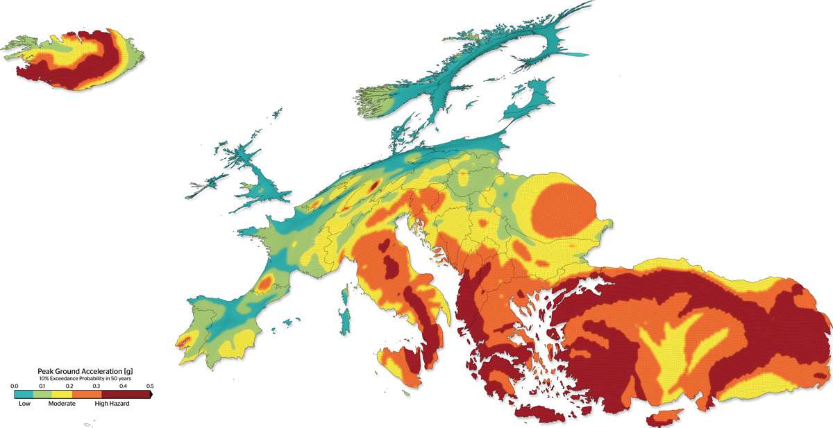
The cartogram shows the spatial variation of seismic hazard in Europe derived from the SHARE model. It highlights the most vulnerable regions by resizing each area according to its so-called Peak Ground Acceleration. The data depicts the 10 per cent ‘exceedance probability’ that a peak ground acceleration of a certain fraction of the gravitational acceleration is observed within the next 50 years. It is therefore a depiction of the ground motions and consequently the related seismic hazard in each area. The colour key categorises these values according to their relative hazard.

The spatial patterns of largest seismic hazards in Europe mostly follow tectonic fault lines. These range from Iceland in the northwest of Europe, situated on the Mid-Atlantic-Ridge, to the North Anatolian Fault zone in Turkey in the southeast. The Balkan and Mediterranean countries, as well as Turkey, with their much denser populations living in regions at high risk, have a long history of destructive and deadly earthquakes. More remote areas, such as Iceland’s highly active and hazardous seismic zone, leave much smaller populations vulnerable to the danger; a strong earthquake here in 1784 (an estimated magnitude of 7.2Mw) caused severe damage to farmhouses and killed three people. In contrast, the first in a series of recent earthquakes in central Italy in August 2016 (magnitude 6.2Mw) led to 299 deaths and caused severe damage to a whole town, leaving 4,500 people homeless. Other earthquakes in Southern Europe and Turkey have cost thousands of lives in the past.

Interdisciplinary and trans-national research on both seismic hazards and a deeper understanding of the links between hazard and risk are important elements in mitigating earthquake damages and reducing the danger for affected populations living in these most hazardous regions.

Benjamin Hennig (@geoviews) is Associate Professor in Geography, University of Iceland and Honorary Research Associate in the School of Geography and the Environment, University of Oxford. He is part of the Worldmapper project and is author of www.viewsoftheworld.net


More great articles…

  • Biggest earthquake: the 10 largest recorded
  • Geo explainer: What is the ring of fire?
  • Rewilding projects are widening European carnivore ranges
  • The Gandhian model of development
  • Mapping the 2019 UK General Election
Subscribe to our monthly print magazine!

Subscribe to Geographical today from just £3.40 per month. Our monthly print magazine is packed full of cutting-edge stories and stunning photography, perfect for anyone fascinated by the world, its landscapes, people and cultures. From climate change and the environment, to scientific developments and global health, we cover a huge range of topics that span the globe. Plus, every issue includes book recommendations, infographics, maps and more!

Stay connected with the Geographical newsletter!

In these turbulent times, we’re committed to telling expansive stories from across the globe, highlighting the everyday lives of normal but extraordinary people. Stay informed and engaged with Geographical.

Get Geographical’s latest news delivered straight to your inbox every Friday!

Filed Under: Science & Environment Tagged With: Earthquakes, Europe

Related articles

Earthquakes of the delta: river avulsions

Earthquakes of the delta: river avulsions

The 10 largest marine protected areas

The 10 largest marine protected areas

Searching for evidence of the Anthropocene

Searching for evidence of the Anthropocene

Groundbreaking discovery suggests some earthquakes alter tectonic plates

Groundbreaking discovery suggests some earthquakes alter tectonic plates

Water scarcity in Africa a ‘myth’

Water scarcity in Africa a ‘myth’

Children of the Marquesas Islands are inspiring a new approach to marine conservation

Children of the Marquesas Islands are inspiring a new approach to marine conservation

Subscribe to our monthly print magazine!

Subscribe to Geographical today from just £3.40 per month. Our monthly print magazine is packed full of cutting-edge stories and stunning photography, perfect for anyone fascinated by the world, its landscapes, people and cultures. From climate change and the environment, to scientific developments and global health, we cover a huge range of topics that span the globe. Plus, every issue includes book recommendations, infographics, maps and more!

Footer

Geographical print magazine cover

  • Facebook
  • Instagram
  • Twitter
  • YouTube

Published in the UK since 1935, Geographical is the official magazine of the Royal Geographical Society (with IBG).

Informative, authoritative and educational, this site’s content covers a wide range of subject areas, including geography, culture, wildlife and exploration, illustrated with superb photography.

Click Here for SUBSCRIPTION details

Want to access Geographical on your tablet or smartphone? Press the Apple, Android or PC/Mac image below to download the app for your device

Footer Apple Footer Android Footer Mac-PC

More from Geographical

  • About Us
  • Contact Us
  • Advertise with us
  • Privacy policy
  • Terms & Conditions

Copyright © 2022 · Site by Syon Media