• Skip to main content
  • Skip to secondary menu
  • Skip to primary sidebar
  • Skip to footer
Geographical

Geographical

Official magazine of the Royal Geographical Society (with IBG)

  • Home
  • Briefing
  • Science & Environment
  • Climate
    • Climatewatch
  • Wildlife
  • Culture
  • Geopolitics
    • Geopolitical hotspots
  • Study Geography
    • University directory
    • Masters courses
    • Course guides
      • Climate change
      • Environmental science
      • Human geography
      • Physical geography
    • University pages
      • University of Aberdeen
      • Aberystwyth University
      • Cardiff University
      • University of Chester
      • Edge Hill University
      • The University of Edinburgh
      • Oxford Brookes University
      • Queen Mary University of London
    • Geography careers
      • Charity/non-profit
      • Education & research
      • Environment
      • Finance & consulting
      • Government and Local Government
    • Applications and advice
  • Quizzes
  • Magazine
    • Issue previews
    • Subscribe
    • Manage My Subscription
    • Special Editions
    • Podcasts
    • Geographical Archive
    • Book reviews
    • Crosswords
    • Advertise with us
  • Subscribe

Why China’s new dam will cast ripple effects far beyond the country

10 April 2025
3 minutes

Xiluodu Dam and Hydropower Plant on Yangtze River in China - ( also Three Gorges Dam and Baihetan Dam built by China Three Gorge Corporation CTGC )
China’s Three Gorges Dam, currently the world’s biggest dam. The Yarlung Tsangpo Dam is set to be three times as large. Image: Shutterstock

Hydropower dam in China likely to lead to downstream environmental repercussions in several major countries


By Victoria Heath

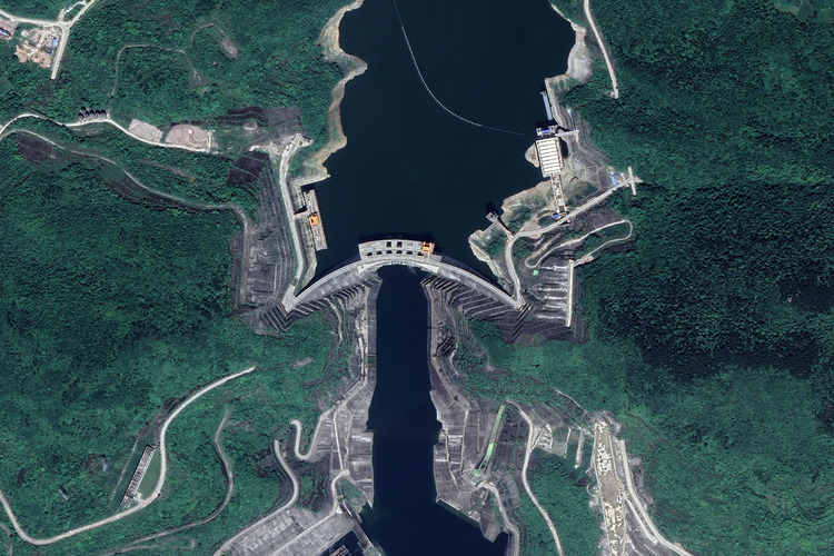
Dams retain water, control flooding, and generate electricity. In the case of China’s latest planned hydropower dam – set to be the largest in the world – these vast structures can also have a far more unexpected quality: sparking great geopolitical tensions.

That’s because the newly proposed $137 billion USD dam is planned to be constructed along a transboundary river (a river shared by two or more countries) – the 496-kilometre-long Yarlung Tsangpo. While the dam will be built in Tibet, its waters eventually flow through India and Bangladesh, where it is known as the Brahmaputra. As lower riparian countries – nations located downstream of the river basin – India and Bangladesh will consequently face any impacts from the new build.


Enjoying this article? Check out our related reads:

  • Dams damned – is the age of vast hydroelectric plants over?
  • As glaciers retreat, what will happen to the land left behind?
  • Dam removal restores flows to historic Klamath River canyon
  • Construction of mega dams in Tibet worries downriver nations
  • Tensions mount over the Grand Ethiopian Renaissance Dam

China & its water control

More than 87,000 dams are in China and Tibet, and many of these infrastructure projects significantly alter water flow to neighbouring countries. Reduced water levels have knock-on effects for nations downstream, from Myanmar to Laos, Cambodia and Vietnam.

In 2020, Chinese dams in the upper Mekong collected more water than ever before, despite droughts in downstream areas. Such droughts led to the river dropping to its lowest-ever level and significantly decreased fish populations.

Tibet the Yarlung Zangbo [Yalu Tsangpo] River,Niyang River,Yamzho Lake
The Yarlung Tsangpo river in China. Image: Shutterstock

Similar concerns over water shortages exist for the Yarlung Tsangpo dam, which may block water into India and Bangladesh. Not only could the dam prevent this vital resource from flowing through, but it could additionally trap vast swathes of sediment upstream, with serious implications for farming.

For one of the world’s most densely populated regions, sediment blocking the Yarlung Tsangpo river may pose a significant threat to food security. Without this issue, Bangladesh already faces the highest head-count poverty ratio (44 per cent), followed by India (27 per cent) and Pakistan (22 per cent). And considering around 70 per cent of Bangladesh’s population lives in the Brahmaputra basin, any alterations to the river will likely have severe impacts on citizens’ livelihoods.

Sediment trapping in the Yarlung Tsangpo river may also accelerate coastal erosion in the Sundarbans – the world’s largest mangrove forest – located in India and Bangladesh. Rich in biodiversity, the forest also plays a pivotal economic role in both countries. Consequently,

Uniting China, India and Bangladesh

In respect to the Yarlung Tsangbo dam, there is currently no treaty or formal agreement binding China, India, and Bangladesh to work on it. In turn, that makes it extremely difficult for the nations to share and appropriately manage the water flowing through.

China has provided hydrological data to India since 2006 – and Bangladesh since 2008 – but some experts argue such agreements are insufficient in preventing water conflicts. As Special Advisor for South Asia at the Parley Policy Initiative Neeraj Singh Manhas explains, a ‘trilateral water-sharing agreement’ may help to ensure any potential conflicts are avoided.

It may sound like a tall order for all three countries to unite together, but it’s possible. Take the example of the Danube river, which currently is protected by a convention upheld by 14 nations alongside the European Union. Looking to the future, this may be the most appropriate way of creating a water-sharing system that benefits all.

Filed Under: Briefing

Protected by Copyscape

Primary Sidebar

Subscribe to Geographical Magazine from just £4.99

Geographical subscriptions

Sign up to our newsletter and get the best of Geographical direct to your inbox

Popular Now

Marauiá mountain range. Yanomami Indigenous Territory, state of Amazonas, Brazil, 2018

Remembering Sebastião Salgado

The lavender fields at Castle Farm

Discovering Britain: Darent Valley, earthly paradise

Map of Gulf of Mexico

Digital cartography on trial: Mexico sues Google for ‘Gulf of America’ label

Glaciologist Ricardo Jaña of the Chilean Antarctica Institute, research chief at the Union Glacier Joint Scientific Polar Station

Life, science and climate urgency on Antarctica’s Union Glacier

UK seas in hot water: the rising threat of marine heatwaves

UK seas in hot water: the rising threat of marine heatwaves

Footer

  • Facebook
  • Instagram
  • LinkedIn
  • Reddit
  • TikTok
  • Twitter
  • YouTube

Geographical print magazine cover

Published in the UK since 1935, Geographical is the official magazine of the Royal Geographical Society (with IBG).

Informative, authoritative and educational, this site’s content covers a wide range of subject areas, including geography, culture, wildlife and exploration, illustrated with superb photography.

Click Here for SUBSCRIPTION details

Want to access Geographical on your tablet or smartphone? Press the Apple, Android or PC/Mac image below to download the app for your device

Footer Apple Footer Android Footer Mac-PC

More from Geographical

  • Subscriptions
  • Get our Newsletter
  • About Us
  • Contact Us
  • Advertise with us
  • Privacy policy
  • Terms & Conditions

Copyright © 2025 · Site by Syon Media