Following flash floods in Kerr County in Texas, take a look at the Guadalupe River – the waterway that surged beyond its banks
By
Earlier this week, fatal flash floods – leading to the deaths of at least 82 people – occurred along the Guadalupe River in Texas. In just 45 minutes, the river rose almost eight metres (26 feet). Forty-one people are currently reported missing, including at least 10 girls from a nearby Christian summer camp, Camp Mystic. A further 850 people have been rescued, including more than 100 airlifted from the region.
Where is the Guadalupe River?
Located in the Texan county of Kerr, the Guadalupe River splits into two forks. The first fork – known as the North Fork – runs east for 22 miles before reaching its confluence with the South Fork. Once converged, the river then flows south-east for 230 miles, passing through the counties of Kerr, Kendall, Comal, Guadalupe, Gonzales, Dewitt and Victoria.
The river forms the boundary between southern Victoria County and Calhoun County, as well as between the Calhoun and Refugio counties.
Check out our related reads:
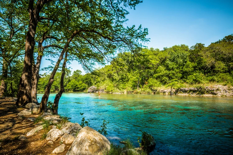
Some parts of the Guadalupe are suitable for canoeing, but small waterfalls located along its path complicate uninterrupted navigation. Other activities such as rafting, fly fishing and tubing take place in the Guadalupe, particularly in areas such as New Braunfels.
The river has likely supported human habitation for several thousand years, with artefacts dating from the Archaic era – a period from the 7th to the 6th century BC –found there.
Because of its steady flow, the Guadalupe and its tributaries have become an attractive candidate for waterpower. The Guadalupe Waterpower Company, established in 1912, constructed a series of dams for the purposes of hydropower. Even today, the river is home to several dams that help power the homes of nearby residents.
Flash flooding
Flash floods are common in the Hill Country, although the levels that occurred earlier this week were markedly more extreme due to a lingering tropical storm, Storm Barry. As well as this, a lack of warning systems in Kerr County, combined with underfunded emergency services – such as the National Weather Service – complicated any attempts of evacuation before conditions became life-threatening.
The Guadalupe River is dubbed ‘flash flood alley’, as it is one of the most likely areas for the weather pattern to occur anywhere in the US. Such weather arises from the state’s unique position, straddling between the cold, dry air from the north and most of the warm air from the Gulf of Mexico. Flash floods are made worse in the area due to the presence of limestone, which prevents water from soaking into the ground.
Climate change is also increasing the likelihood of heavier rainfall in the region, and consequently, flash flooding. This is because a warmer atmosphere causes more water to evaporate from oceans and land, allowing the atmosphere to hold a greater quantity of moisture that is eventually released as precipitation.
What lives in the river?
The Guadalupe River is home to the aptly-named Guadalupe bass (Micropterus treculii) – Texas’s official state fish. According to the IUCN Red List, the species is near threatened. Its biggest threat is hybridisation – the process of two different species breeding together – with the smallmouth bass.
Other species found there include freshwater mussels – referred to as ‘livers of the river’ for filtering water and helping ecosystem health – along with the Guadalupe fatmucket and Texas pimpleback, all of which are endangered.

More than 240 species of birds also call the Guadalupe River their home. These include the endangered golden-cheeked warbler, vermilion flycatcher and scissor-tailed flycatcher.
As well as animals, a vast array of plant life also exists along the Guadalupe River. Bald cypress trees – some centuries old – line its banks, as well as oak-juniper woodlands and grasslands. All of these habitats are vital for the many animals living there.
Drought concerns
While flash floods in Kerr County made headlines recently, the Guadalupe River also experiences the opposite: water scarcity. Studies have shown the region is experiencing a decline in base flow levels, a downward trend attributed to the rising temperatures and reduced rainfall that climate change brings.
Back in March of this year, the river’s flow near Kerrville dropped to around 20 cubic feet per second (CFS), far lower than its average of 89 CFS. To solve this, local authorities encouraged residents to conserve water and limit outdoor irrigation.
Additionally, in the northern Mexican portion of the basin, aquifers are overused. As a result, projections show a 10-20 per cent decrease in rainfall, along with a 1.5–2.5C increase in temperature across the next 50 years.