Ordnance Survey has teamed up with the British Geological Survey to add geological data to the OS Data Hub
Any keen traveller of the British Isles will be familiar with Ordnance Survey (OS) and its detailed maps. Via its Data Hub, the national mapping agency also offers its services to companies and individuals wanting to use its maps and other data in their work or GIS apps.
Now, OS has teamed up with the British Geological Survey (BGS) to offer a wider range of information to users of the Data Hub. BGS is the leading provider of the UK’s scientific earth data and the integration means customers will have access to geological data, enabling the identification of ground hazards such as landslides, susceptibility to erosion and areas with potential for flooding.
This is the first time that OS has used data from a third-party government partner and the organisation says it hopes to add more partners in the future, all with the aim of supporting developers, data scientists and geospatial specialists with access to a broader range of data. The Data Hub was set up in 2020 and now supports around 40,000 individuals and organisations across the public and private sectors, allowing access to addressing data, road networks and greenspace, topography and many more.
The collaboration with BGS was funded by the Government Office of Technology Transfer’s Knowledge Asset Grant Fund which supports public sector organisations. The move follows engagement with OS and BGS’ customers which showed potential benefits to both public and private sectors from greater access to geological data. Now, customers can access OS and BGS data from a single platform, making it easier to create value from geospatial data.
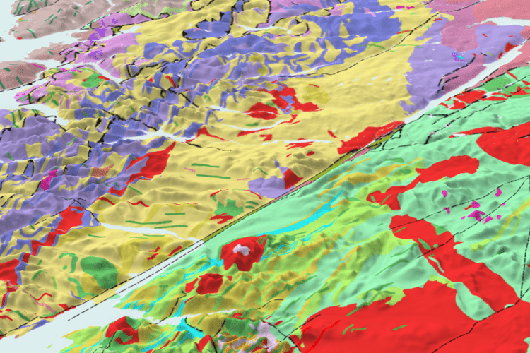
The BGS holds a huge variety of geological data, ranging from digital databases to physical collections such as borehole cores, rocks, minerals and fossils. Nine of their primary datasets will now be included as Open Data in the OS Data Hub. The datasets will provide access to large-scale overview maps of ground hazards, where, for example, there could be landslides that can inform further assessment, and highlight potential hazards that either need to be regraded or investigated in more detail.
The nine BGS datasets now available in the Data Hub:
BGS Geology 625k – bedrock geology showing rock type and lithology for the UK.
BGS Mining hazard (not including coal) 1 km hex grid – this provides a generalised overview of the likelihood for mining to have occurred, a national-scale summary of the presence of mining and an indication of the level of hazard associated with old workings, generalised into a hexagon cell.
BGS GeoSure 5km hex grid – used to inform potential regional ground instability issues and which types of instability might be present for example collapsible deposits, compressible ground, landslides, running sands, shrink-swell and soluble rocks.
BGS GeoClimate UKCP18 Open – datasets show potential change in subsidence due to changes in climate.
BGS GeoCoast Open – contains a detailed suite of statistical data based on the underlying datasets (GeoCoast Premium). These include, for example, percentage of county at threat from inundation and percentage of county coastline with high susceptibility to erosion.
BGS GeoScour Open – provides a generalised overview of the natural characteristics and properties of river areas for the assessment of river sediment.
BGS Hydrogeology 625k digital hydrogeological map of the UK – indicates aquifer potential in generalised terms using classifications defining flow based upon the geology.
BGS/UK Health Security Agency Radon data: Indicative Atlas of Radon – a simplified version of the radon potential dataset with each 1 km-grid square being classed according to the highest radon potential found within it.
BGS Soil Parent Material Model – provides the basic foundations and building blocks of the soil, influencing texture, structure, drainage and chemistry.