Community trekking is the latest development to emerge from the evolution of responsible tourism. The people of the Tigray region in northern Ethiopia have faith it will provide the sacred landscape with a blessed future
By Felicity Aston
I had insisted that a donkey would not be needed. I intended to pack light for the 120-kilometre trek and to carry everything myself. But it seems that the donkey is an immovable component of the experience. Several are dutifully waiting for our group at the trail head, ready with panniers made of halved oil drums. The donkeys are clearly working animals but thick blankets protect their backs from the panniers and they look both cared for and eager to be on the move. It is already late afternoon but the heat still feels like a physical weight bearing down on my head and shoulders. The sweat is immediate. Warily sizing up the rising terrain ahead of us that we need to cover before nightfall, I gratefully deposit my rucksack in an offered pannier.
Stay connected with the Geographical newsletter!
In these turbulent times, we’re committed to telling expansive stories from across the globe, highlighting the everyday lives of normal but extraordinary people. Stay informed and engaged with Geographical.
Get Geographical’s latest news delivered straight to your inbox every Friday!
We are heading away from the outskirts of Adigrat, a sizeable town in the far north of Tigray close to the Eritrean border, and trekking southwards into the Agame Mountains. This is a region that has been the stage for many of the tragedies that have befallen Ethiopia in its turbulent history. Once the seat of power for the ancient Axum Empire that stretched across East Africa, over the last century Tigray has suffered devastating famine, ravaging droughts and a protracted cross-border conflict with its northern neighbour, Eritrea, all while fighting for greater regional autonomy against successive oppressive domestic regimes. Only in the last half-decade has Tigray enjoyed relative peace and stability. Able to offer access to natural beauty, unique wildlife and a distinct regional culture, there is a widespread belief that primarily agrarian Tigray has the potential to use tourism to maintain its newfound security. Yet, the possible pitfalls of developing tourism among fragile communities and landscapes that have so far remained largely untouched by the outside world are also clear.
Geographic location: Northern Ethiopia
Capital city: Mekelle/Mek’ele
Longitude/Latitude: 13.4936° N, 39.4657° E
Land area: 20,710 square miles
Highest point: Ferrah Imba, 3,939 metres
Population: 5.7 million
GDP per capita: $735 (US)
Age demographic: 40 per cent of population under the age of 14
Official language: Tigrinya
Religion: Orthodox Christian (95 per cent), Muslim (5 per cent), Catholic (0.5 per cent)
Calendar: Julian (7 years and 8 months behind the Western Gregorian calendar)

Timeline
1882: Mekelle in Tigray is appointed capital of Ethiopia by Emperor Yohannes IV until his death in 1899
1896: Italian forces accept Ethiopia’s independence following defeat at the Battle of Adwa, north of Mekelle
1977: Tigray People’s Liberation Front launches guerrilla war for regional autonomy from the nationalist Marxist-Leninist Derg Regime
1983/85: Tigray is the epicentre of a drought and famine that leaves 1.2 million people dead. Thousands are forcibly resettled from Tigray
1989: Tigray forces liberate the region from control of genocidal national leader, Mengistu
1999: Ethiopian-Eritrean border clashes in Tigray develop into full-scale war
2000 and 2002: Further devastating droughts across the region
2016-2018: Nationwide government-enforced state of emergency deters tourism in Tigray
2018: Ethiopia and Eritrea make peace as Ethiopia agrees to vacate disputed territory in Tigray
Tourist appeal
Keen to ensure that the local population remains at the heart of any emerging tourism industry, in 2010, Spanish NGO, Manus Unidas, and Irish Aid collaborated to provide seven communities lying within the Agame massif with funding to build guesthouses. The houses were all built to a similar design which combined local style and materials with consideration of the need for tourist appeal. Constructed as a square around a central gated courtyard, the stone buildings feature an indoor long-drop toilet, mattresses and linen in the shared bedrooms, and a private open-roofed area to have a bucket shower. Each guesthouse is also situated in a stunning mountain-top location and deliberately spaced a comfortable day’s trek apart, creating an appealing, but challenging, multi-day trekking route across the semi-arid highlands of eastern Tigray.
To ensure that the benefit of foreign visitors is felt as widely and as directly as possible, the guesthouses are not just built and owned by the local community – every role involved in the hosting of guests is taken on by those living nearby; from the washing of linen and the cooking of meals, to the supply of bottled water and providing donkeys to carry luggage (hence the obligatory donkey assistance – I now understand that to refuse the donkey would be to unwittingly deprive someone of their tourist income). Visitors are passed from community to community like batons in a relay race by locals acting as guides who can navigate the web of ancient pathways that criss-cross the landscape.

Climate
Tigray region is drier than other parts of highland Ethiopia and has a less reliable rainy season, leaving it prone to severe droughts. It is therefore very sensitive to climate change and with more than 80 per cent of the regional population reliant on rain-dependent agriculture, the risk is a devastating impact on food security and more general regional stability, as well as on a fragile ecology. In recent decades annual rainfall has decreased by 32mm and mean annual temperature has increased by 0.4°C. Since 1991, the Tigray regional government has taken positive action by improving soil and water conservation and closing off 1.2 million hectares of land for regrowth. As a result of using community volunteers to implement irrigation projects and to build stone terraces that prevent desertification, it has already recorded significant rising groundwater levels and reduced soil erosion. In 2016, a collaboration of NGOs including WeForest, Trees For Farmers, EthioTree and Mekelle University launched a project to reforest Tigray. Using parcels of land called ‘exclosures’ which are protected from agricultural practices and restored through the planting of trees and the introduction of bees, the initiative has so far restored 56 hectares with 64,455 trees planted.
Sacred landscapes
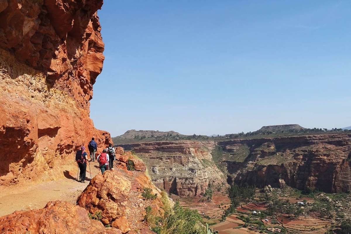
As we progress further into the Agame mountains, accompanied each day by a new local guide, the landscape begins to look less like my imaginings of an African wilderness and more like a Hollywood depiction of the Wild West. Ancient cactus forest and stands of eucalyptus trees cover elevated mesas of flame-red rock tipped with crumbling buttes and dramatic pinnacles. The narrow gullies and slim ledges that form the paths up and down the otherwise sheer mountainsides are often as astonishing as the colours of the sandstone underfoot.
We spend days contouring erosion-sculpted cliffs, the mauve colour of blackcurrent sherbet. This extraordinary geology is the source of Tigray’s best- kept secret; at least 121 rock-hewn churches carved into the mountainsides, often hundreds of metres above the valley floor and more than 3,000 metres above sea level. Unknown by the wider world until the 1970s, many of the churches date back to the fifth century AD and contain medieval wall-paintings as well as important early Christian manuscripts and liturgical objects. Together, they have been placed on the UNESCO World Heritage Tentative List since 2018, referred to as the ‘Sacred Landscapes of Tigray’.
As we pass through a scattered village of small- holdings and ploughed fields our guide sends up a cry to locate the priest. Accordingly, an elderly man waits for us in the shade of a large cactus at the foot of a seemingly sheer escarpment. The church of Debre Giyorgis is located on a ledge three-quarters of the way up the cliff face. The priest nimbly shows us the way, scaling alarmingly flimsy ladders of casually lashed-together eucalyptus poles which flex disturbingly underfoot as we follow. The route involves shuffling across narrow ledges hanging above the valley far below, scrambling up through boulders and the occasional stretch of concrete steps that cling to the rock face apparently by nothing more substantial than magic. The effort and the exposure is worth it however, for a few minutes inside the church.

Physical geography and geology
Tigray is dominated by the northern reaches of the Ethiopian highlands, a chain of largely flat-topped mountain massifs and deep-cut valleys that form the spine of the country. To the north of Tigray lies Eritrea, the border in part delineated by the River Mereb, while to the east lies the Danakil Depression, an area of intense geothermal activity formed by three tectonic plates moving apart. At its lowest point, this geologic depression is 116 metres below sea level and by annual average temperatures, it is the hottest place on Earth. UNESCO describes the sacred landscape of Tigray as ‘an intimate expression of the underlying geology’. Layers of brightly coloured sandstone, washed out as sediment from the melting glaciers of the original continent, Gondwanaland, have been eroded to form vast Grand Canyon-like structural reliefs, spectacular bastions, mesas, buttes and pinnacles 300 metres high. On the surface, Adigrat sandstone appears in an array of colours, from red to yellow to pink and is veined with quartz. Beneath it lies Enticho sandstone which is white and glacial in origin with iron-rich seams. It is the soft, friable nature of these sandstones across the Tigray region that enables the centuries-old tradition of sculpting structures directly into the rock.


Half cave, half timber structure, the church is covered inside by brightly coloured patterns and murals, first painted some 1,600 years ago. Religious or not, floating high above the Gohgot Valley enjoying the cool shade of the mountain, infused with incense and surrounded by the heavy presence of time feels memorably spiritual. Debre Giyorgis, like the vast majority of Tigray’s rock-hewn churches, are not relics but a much-used place of worship cherished by the surrounding communities. The predominately Ethiopian Orthodox population is religiously devout and as guests of the community we are permitted an intimate insight into their religious life. Most mornings we are woken by the voices of priests calling the population to mass, their incantations floating across the valleys of the mountain chain via loudspeaker. Perched half way up a valley wall, outside the church of Maryam Bahera, we watch as a funeral procession gathers everyone from the valley in open fields. The men stand in a solemn circle around the coffin while the women congregate nearby in their best dresses, everyone cloaked in striking white shawls required for religious observances.
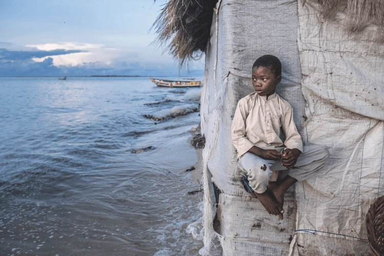
One of our local guides invites us to a holy day celebration being held at his neighbour’s home. We are welcomed into a traditional homestead and join several dozen other guests in a freshly swept and grass-scattered barn. The host’s wife serves us tihlo, balls of barley dough dipped into shiro, Ethiopia’s chickpea staple, and a chilli-based berbere sauce as fiery as the rock of the encircling mesas. We had been advised to bring gifts for our hosts and after the meal eagerly present our appreciation in what turns out to be a rather badly judged moment. The host, a very private farmer, seems as bemused by our rigorously practical gifts of solar lamps and penknives as he is embarrassed by all the attention. We leave the celebration stalked by the feeling that despite our best intentions we have somehow got it wrong.
It is a sentiment that becomes familiar as we walk in and out of local people’s lives and particularly when attracting the attention of groups of children, all guilelessly asking for money, pens, sweets and sometimes shoes. Tourism in a place with such a scale of challenges, both social and environmental, is perhaps always going to be plagued with issues of ethics. Yet, these concerns mostly fade in the face of the hopes held by the people of Tigray. We are told of the village of Mequat Mariam where the community trekking scheme has been so successful that they have used some of the resulting income to fund a ‘grain bank’, buying in grain to build an excess that can be loaned to community members in times of shortage and later repaid with interest.
Nature: monkeys and vultures
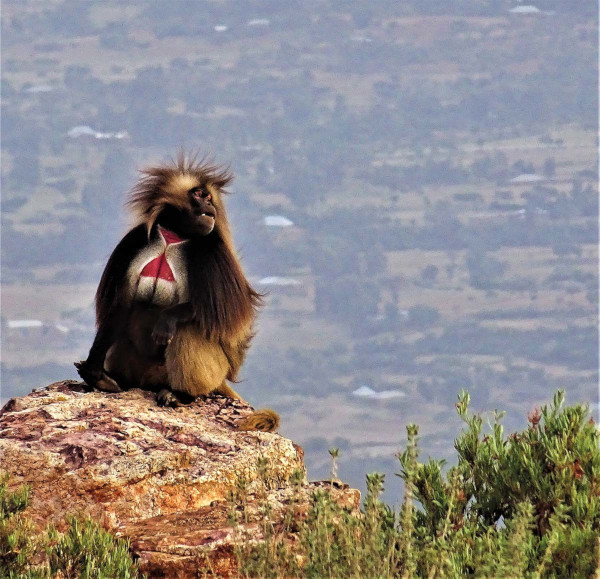
Of the many species of mammal and avifauna endemic to Ethiopia, several of the most striking thrive in Tigray. Large troops of gelada monkey, the world’s only species of grazing monkey, roam the high table-top plateaus of the Agame Mountains, living in caves that pock the range’s steep cliffs. The monkeys, which have the appearance and size of a baboon, have a highly complex social structure and stand out due to their scarlet chest and impressive mane. Unfortunately, troops of up to 1,000 individuals can result in extensive crop damage, leading to significant tension between wildlife and local people.
The vertiginous mountainsides of Tigray are also favoured by lammergeier (bearded vultures). These scavengers, notable for their feathered heads, exist almost entirely on a bone diet and can reach over one metre long with a wingspan of nearly three metres. While the global population of fewer than 7,000 individuals is decreasing and has been included on the IUCN Red List of Threatened Species as ‘near threatened’ since 2017, lammergeier are a relatively common sight above 2,000 metres in Tigray.
Template for the future
Everywhere we go in Tigray, we are greeted with overwhelming enthusiasm. Several times local people express their wish that we not only return, but bring more tourists. It is clear that the communities of the Agame massif are positive about community trekking and that other regions are keen to follow suit. Following the template established in Tigray and the original initiative founded near Lalibela, further south, two more community trekking projects have now been developed in the Simien National Park and Wof Washa Forest by NGOs. Not everything is easy, and not everything feels natural, but if tourism is to happen in Tigray, this does feel like a responsible way to do it, while simultaneously providing a very special portrait of a most wonderful and ancient culture.

Subscribe to our monthly print magazine!
Subscribe to Geographical today for just £38 a year. Our monthly print magazine is packed full of cutting-edge stories and stunning photography, perfect for anyone fascinated by the world, its landscapes, people and cultures. From climate change and the environment, to scientific developments and global health, we cover a huge range of topics that span the globe. Plus, every issue includes book recommendations, infographics, maps and more!