A new map of Africa could help descendants of the transatlantic slave trade to finally trace their roots
By
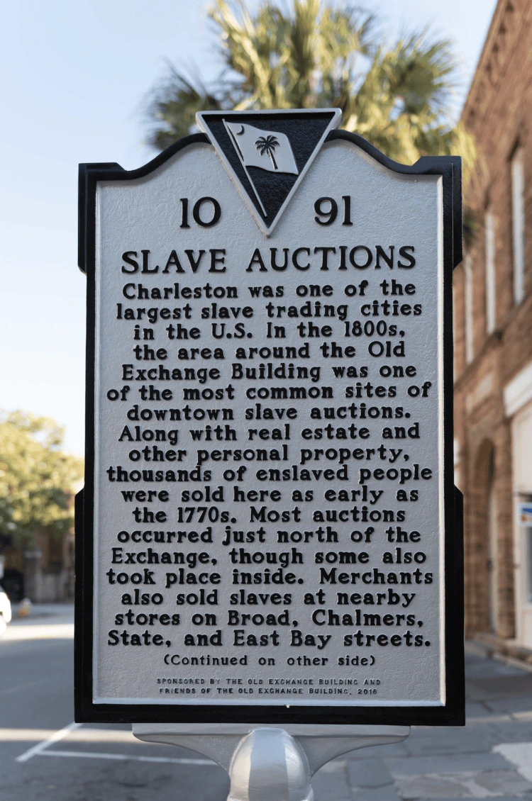
For many descendants of enslaved people in the USA, tracing their ancestry is a difficult, often impossible task. In Charleston, South Carolina, once one of the most prolific slave-trading ports in the country, researchers and community leaders have been working to identify the origins of individuals in a late-18th-century burial site – the Anson Street African Burial Ground – that was unearthed in 2016.
While initial findings from ancient DNA indicated origins in West and sub-Saharan Africa, scientists have struggled to narrow down the search, until now.
Enjoying this article? Check out our related reads:
Vicky Oelze was working on a wildlife biomonitoring project (the Pan African Programme) when her research sparked an idea. The team had been developing a map of local strontium distribution, which it was using to track chimpanzee communities in the Ivory Coast. The project had already amassed a sizeable collection of organic samples (soil and plants) needed for the map from across equatorial Africa. Could sampling be expanded across the continent?
Strontium is a soft, silvery-white and highly reactive metal that gives fireworks and flares their crimson glow. It comes in different chemical forms, called isotopes. Strontium-90, a radioactive isotope, is a hazardous by-product of nuclear fallout, but the natural forms found in rocks, soil, dust, coal, oil and water are harmless.
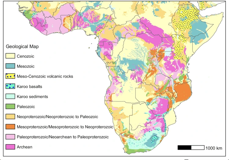
Depending on where it is found, the ratio between two specific strontium isotopes, 87Sr and 86Sr, varies; younger, basalt rocks, for example, typically have lower 87Sr/86Sr ratios than older, crystalline ones.
Scientists can estimate the geographic origin of any organic material – no matter whether it’s a tooth from a human or animal, a piece of timber or a butterfly’s wing – by analysing this ratio within a sample of the material. Since strontium isotopes in an organism closely reflect those of the underlying geology where it lived or fed, matching these results to a map of known strontium isotopic ratios effectively reveals its origin.

The region’s first strontium isoscape.
Strontium isotope maps are useful tools for archaeologists, conservation scientists, and forensics experts looking to track the movement of humans or wildlife, or to trace the origins of artefacts, illegally traded wild- life products (such as ivory or fur) and human remains. For over a decade, Vicky Oelze and colleagues at the University of California, Santa Cruz, in partnership with archaeologists and conservationists throughout Africa, have been working to overcome the significant gaps in data that have prevented comprehensive strontium isotope mapping of the continent. Their work has now produced the first map of its kind.
The study is a major collaborative effort, from sample collection to analysis – most of which was undertaken by lead author Xueye, who spent all day (and sometimes night) in the lab for more than a year. ‘It typically takes two weeks to process the treatment, chemical separation and analysis of a batch of roughly 19 samples,’ says Wang, who processed close to 800 samples in all.
‘But I actually enjoy it, it’s calming to focus on the experiments. It’s not particularly challenging,’ she adds, noting that she’d already processed more than 1,000 samples to produce the first strontium isotope map of China by the time she joined Oelze’s project.
Strontium offers one key advantage over ancient DNA when it comes to tracing the origins of an arte- fact; it doesn’t decay over time. ‘The issue, as you’ll see from the map, is there are whole areas that have very similar strontium isotope ratios,’ says Oelze.
‘If you’re only working with strontium isotopes, that could leave you with huge swathes of land that have a 100 per cent match. But strontium is a very, very useful tool in cases where we have unique strontium isotope values.’ The geology of western central Africa is so diverse that it makes this a perfect landscape to use this method.
So far, the map has been used to precisely trace the origins of two people found in the Anson Street African Burial Ground: Kuto and Banza (both named by the Charleston community), who were both brought to the US from western Angola. Wang hopes that the map will continue to contribute to the restoration of the identities, cultures, and lives of individuals and communities whose rights and lives were stripped away during the colonial period.
Oelze, meanwhile, already has her eyes on another potential region to be mapped: Brazil. ‘I’m in conversation with several colleagues there who are interested in the movement of illegal timber, trafficked animals and migratory animals… and I want to look at the impact of the slave trade beyond North America.’