• Skip to main content
  • Skip to secondary menu
  • Skip to primary sidebar
  • Skip to footer
Geographical

Geographical

Official magazine of the Royal Geographical Society (with IBG)

  • Home
  • Briefing
  • Science & Environment
  • Climate
    • Climatewatch
  • Wildlife
  • Culture
  • Geopolitics
    • Geopolitical hotspots
  • Study Geography
    • University directory
    • Masters courses
    • Course guides
      • Climate change
      • Environmental science
      • Human geography
      • Physical geography
    • University pages
      • University of Aberdeen
      • Aberystwyth University
      • Cardiff University
      • University of Chester
      • Edge Hill University
      • The University of Edinburgh
      • Oxford Brookes University
      • Queen Mary University of London
    • Geography careers
      • Charity/non-profit
      • Education & research
      • Environment
      • Finance & consulting
      • Government and Local Government
    • Applications and advice
  • Quizzes
  • Magazine
    • Issue previews
    • Subscribe
    • Manage My Subscription
    • Special Editions
    • Podcasts
    • Geographical Archive
    • Book reviews
    • Crosswords
    • Advertise with us
  • Subscribe

Ceredigion: the geographical centre of Wales

27 February 2024
3 minutes

Looking down on the abandoned mines in the Ystwyth Valley
Looking down on the abandoned mines in the Ystwyth Valley. Image: Jon Moorby/Shutterstock

Rory Walsh visits the heart of Wales – Ceredigion, the country’s central point and home to its hidden treasures


View • Rural • Wales • Guide

Middle England is a socio-political term rather than an actual place. Yet identifying the centre of the country stirs debate. The established candidate is Meriden, near Coventry, where a monument on the village green marks the historic Centre of England. The Ordnance Survey suggests somewhere 18 kilometres north. Using gravitational mapping – finding the spot where a map of the country balances on a pin – they calculate the middle of England to be a field near Fenny Drayton, Leicestershire.

Locating the centre of Scotland is complicated by the islands – especially their tidal coastlines. Following the OS method, the centre of the mainland is five kilometres east of Schiehallion. The middle of Wales, meanwhile, is in Ceredigion, on the border of two farms 2.5 kilometres south of Cwmystwyth. 

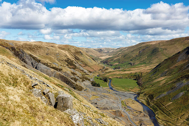
Cwmystwyth village is named after the River Ystwyth, which flows west through the Cambrian Mountains. Head east from the village, and vast views soon span the upper Ystwyth Valley. As the river rushes beside the road, the mountains tower on either side. In summer, their steep flanks are a sea of greens; in winter, an ocean of oranges. Grey stone outcrops on the valley floor seem tiny, strings of beads dropped by a careless giant.

Lining the road are crumbling clusters of ruined buildings – the remains of the Cwmystwyth mine. From the Bronze Age, lead, silver, zinc and copper were mined at Cwmystwyth. The peak took place in the 18th century when hundreds of men toiled in all weather to extract and process ores from the valley’s slopes. The risk of lead poisoning was such that a miner’s life expectancy was 32. 

Discover more about Britain…

  • Discovering Britain: A Geographical pub crawl
  • Devil’s Dyke: the longest, deepest and widest dry valley in Britain
  • Surf’s up: discovering the secrets of Widemouth Bay
  • Glen Roy: the high road and the low road
  • Discovering Britain: West Norwood cemetery

Mining was the product of the local landscape. The formation of the Cambrian Mountains lifted and folded seams of metals and minerals into accessible lodes. Over centuries, the River Ystwyth provided a constant water supply for different uses, from washing the ore to powering furnaces. Despite this abundance of natural resources, Cwmystwyth mine was never profitable and closed after the Second World War. 

The mine is now a scheduled ancient monument. Its historic importance was confirmed in 2002 when an archaeological dig nearby uncovered a Bronze Age grave. Within it was the Banc Ty’nddôl ‘sun-disc’. The size and shape of a coin, it’s the oldest gold artefact ever found in Wales. Like the abandoned mine, the recovered sun disc shows that the heart of Wales beats with hidden treasures.


Discovering Britian logo
Go to the Discovering Britain website to find more hikes, short walks, or viewing points. Every landscape has a story to tell!

Filed Under: Culture Tagged With: Discovering Britain, March 24

Protected by Copyscape

Primary Sidebar

Subscribe to Geographical Magazine from just £4.99

Geographical subscriptions

Sign up to our newsletter and get the best of Geographical direct to your inbox

Popular Now

The rush for rare earth elements

The rush for rare earth elements

Golden Visas – Who’s Buying Residency Around the World?

Golden Visas – Who’s Buying Residency Around the World?

Pod of humpback whales in Tonga

Superhighways to protect migrating whales

nespresso machine

Business models that aren’t fit for every purpose

QUIZ: Flags of the World – Hard

QUIZ: Flags of the World – Hard

Footer

  • Facebook
  • Instagram
  • LinkedIn
  • Reddit
  • TikTok
  • Twitter
  • YouTube

Geographical print magazine cover

Published in the UK since 1935, Geographical is the official magazine of the Royal Geographical Society (with IBG).

Informative, authoritative and educational, this site’s content covers a wide range of subject areas, including geography, culture, wildlife and exploration, illustrated with superb photography.

Click Here for SUBSCRIPTION details

Want to access Geographical on your tablet or smartphone? Press the Apple, Android or PC/Mac image below to download the app for your device

Footer Apple Footer Android Footer Mac-PC

More from Geographical

  • Subscriptions
  • Get our Newsletter
  • About Us
  • Contact Us
  • Advertise with us
  • Privacy policy
  • Terms & Conditions

Copyright © 2025 · Site by Syon Media