Six typhoons hit the Philippines in one month. Find out more about these devastating events & why exactly the country is so prone to typhoons
By
Over the course of just one month, the Philippines has been hit by back-to-back typhoons, a devastating weather pattern described as ‘unusual’ by forecasters and not seen in the region since records began.
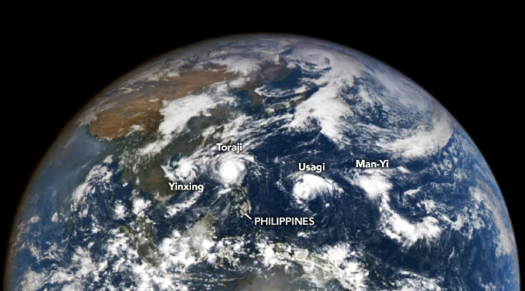
The onslaught of typhoons – also often known as tropical cyclones – first began back in October with Tropical Storm Trami (known as Kristine locally), where a month’s rainfall fell in the northern Philippines, followed by Kong-Rey (Leon), Toraji (Nika), Usagi (Ofel), Typhoon Yinxing (Marce) and super typhoon Man-yi (Pepito).
At one point, four of these storms were co-existing in the Pacific Basin at once, making it difficult for experts to discern the individual impacts of each of these natural disasters as multiple incidences of flooding, landslides and power outages were occurring at once.
Enjoying this article? Check out our related reads:
The most recent of these typhoons, Man-yi, exceeded sustained wind speeds of 185km/h and made two landfalls – the first on 16 November in Panganiban, Catanduanes and again in Dipaculao, Aurora Province on 17 November.
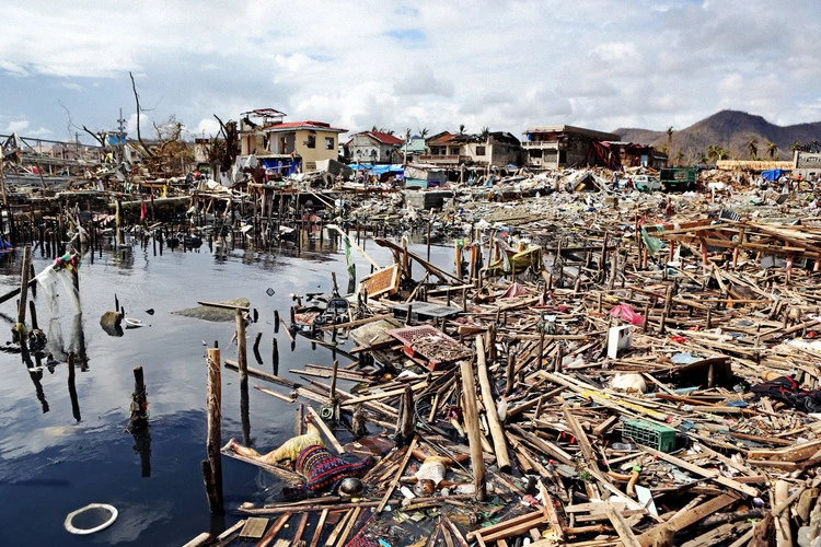
Collectively, these recent weather events have impacted more than 10 million individuals across 17 out of Philippines’ 18 regions. At least 160 people have died during the typhoons and a further 1.4 million displaced, who have limited access to food, water and sanitation.
Typhoon season in the Western Pacific usually stretches across the entire year, but most storms forming between May and October. November usually sees three named storms – with one becoming a super-typhoon – based on recorded averages between 1991 and 2000.
So what exactly makes the Philippines so prone to typhoons?
Pacific Typhoon Belt
One of the major reasons as to why the Philippines gets so many typhoons is due to its location on the Pacific Typhoon Belt, an area in the Pacific where nearly one-third of the world’s tropical cyclones form. Each year, around 19 typhoons enter the country with between six and nine making landfall.
Almost all areas of the country are at risk of typhoons, but direct landfall usually occurs in the western and northern provinces – with Cagayan Valley, Bicol and Eastern Visayas the most affected.
The vast number of islands which make up the country – 7,641 – means it has an extremely high number of coastal areas, making it even more vulnerable to the devastating impacts a typhoon can wreak.
It’s not just typhoons that the Philippines is prone to, but other natural disasters too. Estimations suggest 60 per cent of its land – and more than 70 per cent of its total population – are exposed to hazards including floods, droughts, earthquakes, tsunamis, landslides and cyclones.
The most at-risk country in the world
Despite being located in the Pacific Typhoon Belt hotspot, the Philippines also experiences another factor which exacerbates its extreme weather events: climate change and global warming. For example, rising sea temperatures – caused by global warming – typically cause typhoons to be less frequent but far more powerful.
Although a warming planet is unlikely to cause an increase in the number of tropical cyclones globally, according to the IPCC, it is ‘very likely’ that storms will have higher levels of rainfall and wind speeds – meaning more would enter the dangerous and life-threatening top categories.
The risks of climate change and global warming to the country are factors that have been quantified several times now – and for the third year in a row, the Philippines has ranked first in the World Risk Report.
Analysing 193 countries, the report considers levels of exposure, vulnerability and adaptive capacities to crises including natural disasters, conflicts, pandemics and wars between all nations. Coming out top in this report is one situation where being last is better – as it means the Philippines is the most at-risk country to negative impacts from the climate crisis (followed by Japan, Bangladesh, Myanmar and China).
In recent years, the overlapping crises of the COVID-19 outbreak – along with 22 tropical cyclones in the country during that time – combined together to intensify the burdens placed on the Philippines. This feedback loop is one in which worsening natural disasters make tackling public health crises even harder, and vice-versa: more destroyed homes through typhoons and similar disasters leads to overcrowded evacuation centres – and in turn, more coronavirus cases due to the close proximity of evacuees.
But even though the pandemic has ended, the Philippines is not in the clear. It still faces sizeable threats from the impacts of climate change alone. One study suggests that 150 million people currently live in areas set to be submerged by 2050 – with 70 per cent of these at-risk people living in Southeast Asia, including the Philippines.
The thousands of islands that make up the Philippines also mean many people are exposed to the impact of rising sea levels, such as flooding, landslides and the entire loss of their homes and infrastructure.