• Skip to main content
  • Skip to secondary menu
  • Skip to primary sidebar
  • Skip to footer
Geographical

Geographical

Official magazine of the Royal Geographical Society (with IBG)

  • Home
  • Briefing
  • Science & Environment
  • Climate
    • Climatewatch
  • Wildlife
  • Culture
  • Geopolitics
    • Geopolitical hotspots
  • Study Geography
    • University directory
    • Masters courses
    • Course guides
      • Climate change
      • Environmental science
      • Human geography
      • Physical geography
    • University pages
      • Aberystwyth University
      • Brunel University
      • Cardiff University
      • University of Chester
      • Edge Hill University
      • The University of Edinburgh
      • Newcastle University
      • Nottingham Trent University
      • Oxford Brookes University
      • The University of Plymouth
      • Queen Mary University of London
    • Geography careers
      • Charity/non-profit
      • Education & research
      • Environment
      • Finance & consulting
      • Government and Local Government
    • Applications and advice
  • Quizzes
  • Magazine
    • Issue previews
    • Subscribe
    • Manage My Subscription
    • Special Editions
    • Podcasts
    • Geographical Archive
    • Book reviews
    • Crosswords
    • Advertise with us
  • Subscribe
    • Direct Debit Changes

New maps help conserve Ascension Island MPA

1 April 2025
2 minutes

BGS’s 1:50 000-scale geomorphology map of the seabed around Ascension Island.
The 1:50 000-scale geomorphology map of the seabed around Ascension Island. Image: BGS

British Geological Survey maps are poised to aid conservation of one of the largest marine-protected areas in the world


By Victoria Heath

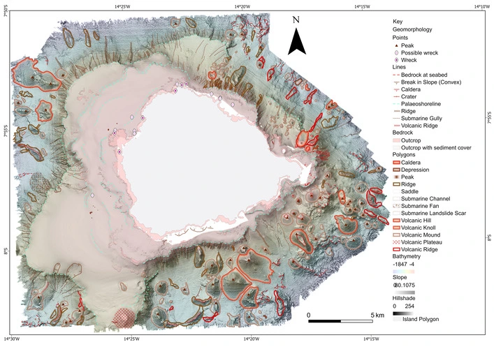
A new set of maps produced by the British Geological Survey has offered the first detailed insights into one of the largest marine-protected areas in the world, the Ascension Island Marine Protected Area (MPA).


Enjoying this article? Check out our related reads:

  • The 10 largest marine protected areas
  • Supertrawlers spent more than 7,300 hours fishing in UK MPA’s since Brexit
  • Ordnance Survey adds geological data to its Data Hub

Stretching for 445,000 square kilometres in the South Atlantic Ocean, the MPA is home to numerous endemic species and a plethora of both deep sea and open ocean habitats – many of which are yet to be explored. The actual Ascension Island itself also features the second-largest breeding population of green turtles in the Atlantic, as well as more than half a million nesting seabirds.

Since 2019, the Ascension Island MPA has been safeguarded from activities such as large scale commercial fishing and mineral extraction – as well as having restrictions imposed on waste discharge – but it still faces a pertinent threat from human-induced development and climate change.

That’s why researchers hope these newly created maps – constructed using high-resolution surveys, depth and seabed composition data alongside specialised video and photography – will help to continue conserving such a unique region in the long term and ensure safer navigation for future exploration.

Dubbed a ‘significant milestone’ by BGS marine geoscientist Catriona Macdonald, the findings detailed within the maps were extensive, ranging from discoveries of features such as seamounts, submerged lava flows, ridges and submarine landslides to more detailed understandings of the exact composition of sediment in nearshore areas. Some data was also recorded in areas previously unexplored by historic surveys.

‘Collecting data in such a remote and exposed location was a challenge, but an absolute privilege and pleasure,’ said BGS Project Manager and Senior Surveyor Rhys Cooper.

Collectively, this information will provide further insight into the multiple ecosystems within the MPA’s waters.

Marine life filmed as part of the video transect work around the coast of Ascension Island. BGS © UKRI 2025.
Marine life filmed as part of the video transect work around the coast of Ascension Island. Image: BGS 

To further ensure the maps contribute toward the MPA’s betterment, the BGS also provided training to the Ascension Island Government (AIG) on how to modify and add new data as more knowledge becomes available. The maps will continue to be used by the government for future generations.

‘AIG are excited to have access to such high-quality bathymetry and habitat maps,’ said Director of Conservation and Fisheries of the Ascension Island Government Tiffany Simpson. ‘They will be transformative in our nearshore research and monitoring and allow for much more evidence-based conservation management.’

Themes Briefing Marine wildlife

Protected by Copyscape

Primary Sidebar

OUR UK DIRECT DEBITS ARE CHANGING
SPRING SALE

Geographical subscriptions

GEOGRAPHICAL WEEKLY LOGOFREE - Sign up to get global stories, told well, straight to your inbox every Friday

Popular Now

On The Ground: The new podcast from Geographical

On The Ground: The new podcast from Geographical

QUIZ: Country Spotlight – Sweden

QUIZ: Country Spotlight – Sweden

Out now: April Geographical Magazine

Out now: April Geographical Magazine

QUIZ: Geography Trivia

QUIZ: Geography Trivia

QUIZ: Country Shapes – Hard

QUIZ: Country Shapes – Hard

Footer

  • Facebook
  • Instagram
  • LinkedIn
  • Reddit
  • TikTok
  • Twitter
  • YouTube

Geographical print magazine cover

Published in the UK since 1935, Geographical is the official magazine of the Royal Geographical Society (with IBG).

Informative, authoritative and educational, this site’s content covers a wide range of subject areas, including geography, culture, wildlife and exploration, illustrated with superb photography.

Click Here for SUBSCRIPTION details

Want to access Geographical on your tablet or smartphone? Press the Apple, Android or PC/Mac image below to download the app for your device

Footer Apple Footer Android Footer Mac-PC

More from Geographical

  • Subscriptions
  • Get our Newsletter
  • About Us
  • Contact Us
  • Advertise with us
  • Privacy policy
  • Terms & Conditions

Copyright © 2026 · Site by Syon Media