Rory Walsh visits the divisive New Town that became a city
Trail • Urban • South East England • Web Guide
Officially founded on 23 January 1967, Milton Keynes has been much maligned ever since. Common descriptions include ‘soulless’ and ‘bland’. A city of roundabouts where famously even the cows are made of concrete. Pop group the Style Council dismissed Milton Keynes in song, while online polls have voted it one of the world’s ‘most boring’ cities. Yet residents include the Bletchley Park codebreakers, a giant Tyrannosaurus Rex and a Formula 1 racing team. The streets even align with the cosmos.
‘The city is set in a grid,’ explains Martin Haslett, a retired town planner who created this trail in 2017, the year of Milton Keynes’ 50th anniversary. ‘When planners were creating the layout, they discovered that the main street almost framed the rising sun on the Summer Solstice. So they tweaked the design to line it up with the sunrise and named the road Midsummer Boulevard. I always think Milton Keynes is a place that people love to criticise but things like that show how it was created with utopian ideals.’
Milton Keynes’s origins began with the end of the Second World War, which left Britain facing a severe housing shortage. ‘In 1946, the government established a plan to design and develop a series of New Towns,’ Haslett explains. ‘The idea was to create new places for people to live, beyond densely populated cities. Milton Keynes was the last and by far the largest.’ Milton Keynes Borough now covers more than 190 square kilometres, taking in several historic towns and villages.
We begin our walk in a scenic open space. From Glebe Roundabout, steps lead uphill into Campbell Park. At the top, a path beside a totem pole curves across lush grass. Soon, a cone-shaped hill appears on the right. It recalls an Iron Age hillfort, complete with a flock of grazing sheep – a wonderfully whimsical surprise. ‘Before Milton Keynes was built, this part of north Buckinghamshire was a flat rural area mostly used for farming,’ says Haslett. ‘Slopes and hills were created using spoil from the construction work and modelled upon the South Downs.’
Roughly equidistant from London, Birmingham, Leicester and Oxford, the site was carefully chosen and promoted as a place to start a new life in the country. ‘Milton Keynes was a modern interpretation of a Garden City,’ Haslett explains. ‘Garden Cities were the brainchild of Ebenezer Howard, who proposed in 1898 that cities could incorporate both town and countryside.’
Today, Milton Keynes has 2,000 hectares of parkland and 22 million trees. The city’s official website states that locals are never more than half a mile (800 metres) from a park. As we leave Campbell Park, we meet another of the city’s defining features: the roads. Two underpasses lead us under the junction of H6 Childs Way and V8 Marlborough Street, dual carriageways humming with fast-moving vehicles. ‘To help people navigate, the horizontal “H” roads are called ways, while the vertical “V” roads are streets,’ Haslett explains.
Haslett drove to Milton Keynes from his home in Leamington Spa. ‘It’s easy. There’s rarely any traffic and lots of parking.’ In central Milton Keynes, fields of street-level car parks have more than 20,000 spaces. Meanwhile, 130 roundabouts keep everyone moving. Haslett suggests that many people pass through without realising. ‘They drive along past rows of trees, never get out of the car and don’t think much about it.’ A first-time visitor, I found the roads rather baffling, but I had arrived on foot.
Walking in a car-centric city creates some strange sensations. One is scale. Central Milton Keynes feels very large. Pavements are often metres away from the roads, which seem to spur off into the distance. Besides trees, Midsummer, Avebury and Silbury boulevards are lined with what appear to be giant tables. These are porte-cochères – porches placed at crossings and entrances to provide rain shelter. Another quirk is perspective. Road names are placed at shin height in central reservations; ideal when driving but not so natural for walkers used to looking up for signs on walls and buildings.
‘Planners probably anticipated 100 per cent car ownership,’ Haslett reflects ‘but the roads aren’t barriers.’ Parallel to them are a 320-kilometre network of redways: red-painted paths shared by pedestrians and cyclists. My three-kilometre walk from the railway station to Campbell Park illustrated how they work. Passing offices, hotels and supermarkets, I didn’t have to cross a single road. Instead, I was diverted through underpasses and over footbridges.
The trail follows redways through two of the city’s suburbs: Springfield and Fishermead. In the latter, terraced houses line streets named after Cornish places: Pentewan, Porthlevan, Pencarrow, Padstow. Haslett points out a convenience store, medical centre and playground. ‘Each of the residential areas has its own social facilities, spread evenly across the city grid. The plan was to encourage local communities, with everyday needs a short walk away.’
There are still reminders that Milton Keynes was built in the motoring age. Rather than front gardens, many of Fishermead’s houses have car ports.
A footbridge back over H6 Childs Way leads us past the Xscape, a vast hangar-sized building containing a cinema, casino and dry ski slope. Other landmarks have a filmic, illusory feel. The black glass block of Central Station looks like the obelisk in 2001: A Space Odyssey tipped on its side. The Point, the UK’s first multiplex cinema, could be an Egyptian pyramid made from Meccano. Now closed for a decade, its early screenings included Back To The Future.
Enjoying this article? Check out our related reads:
Yet, it continues to evolve. Britain’s largest New Town became a city in August 2022. Driverless cars have been tested on the roads, while robots use the Redways to deliver shopping remotely. The service made national headlines during the Covid-19 pandemic.
Haslett and I continue towards a more traditional retail source. Until 1997, centre:mk was the world’s longest shopping mall. Renowned for its use of natural light, it’s Grade II listed. Over a coffee, we ponder what we’ve seen so far.
‘Milton Keynes gets criticised for not having a city feel, but think about the alternatives’ Haslett says. ‘If you wanted a new home after the war, you were looking at council housing – probably in a block of flats.’ In 1968, the collapse of the East London tower block Ronan Point led to a move towards low-rise, lower-density housing. ‘In some ways Milton Keynes was ahead of its time.’ While some places defy expectations and others conform to them, Milton Keynes somehow does both.
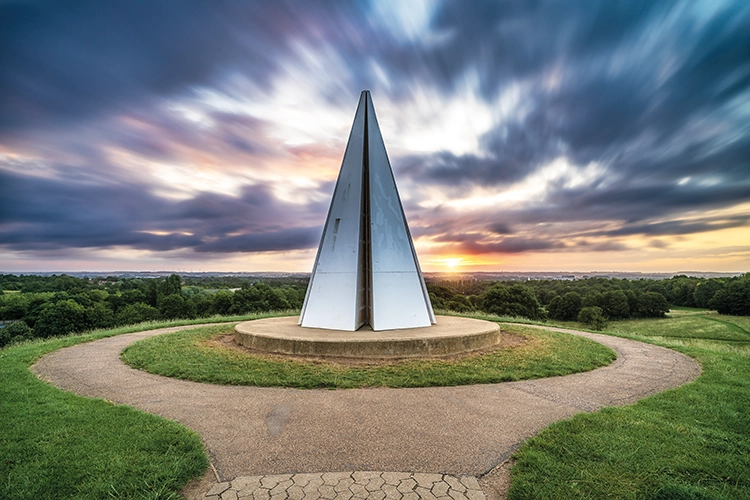
We return to Campbell Park to conclude the trail. On top of the hill that we saw earlier stands the Light Pyramid, a sculpture lit like a beacon for special occasions. Milton Keynes has more than 200 public artworks. The infamous concrete cows refer to the city’s agricultural origins and offer a riposte to critics who claimed that children wouldn’t see any farm animals. The Light Pyramid meanwhile almost glows in the approaching dusk. Nearby sheep still nuzzle the grass. While cars waft below, views span the surrounding countryside. Haslett reflects, ‘Milton Keynes just isn’t like other cities.’
Go to the Discovering Britain website to find more hikes, short walks, or viewing points. Every landscape has a story to tell!