• Skip to main content
  • Skip to secondary menu
  • Skip to primary sidebar
  • Skip to footer
Geographical

Geographical

Official magazine of the Royal Geographical Society (with IBG)

  • Home
  • Briefing
  • Science & Environment
  • Climate
    • Climatewatch
  • Wildlife
  • Culture
  • Geopolitics
    • Geopolitical hotspots
  • Study Geography
    • University directory
    • Masters courses
    • Course guides
      • Climate change
      • Environmental science
      • Human geography
      • Physical geography
    • University pages
      • University of Aberdeen
      • Aberystwyth University
      • Cardiff University
      • University of Chester
      • Edge Hill University
      • The University of Edinburgh
      • Oxford Brookes University
      • Queen Mary University of London
    • Geography careers
      • Charity/non-profit
      • Education & research
      • Environment
      • Finance & consulting
      • Government and Local Government
    • Applications and advice
  • Quizzes
  • Magazine
    • Issue previews
    • Subscribe
    • Manage My Subscription
    • Special Editions
    • Podcasts
    • Geographical Archive
    • Book reviews
    • Crosswords
    • Advertise with us
  • Subscribe

Discovering Britain: Spurn Point in the Humber Estuary

23 December 2024
2 minutes

Spurn Point Lighthouse East Riding Yorkshire
The wonders of Spurn Point are revealed by Rory Walsh in his latest installment, Discovering Britain. Image: Gregory Cullen/Shutterstock

Rory Walsh visits Spurn Point – a strange hook of land reaching out into the Humber Estuary


Walk • Coastal • Yorkshire and the Humber • Web Guide

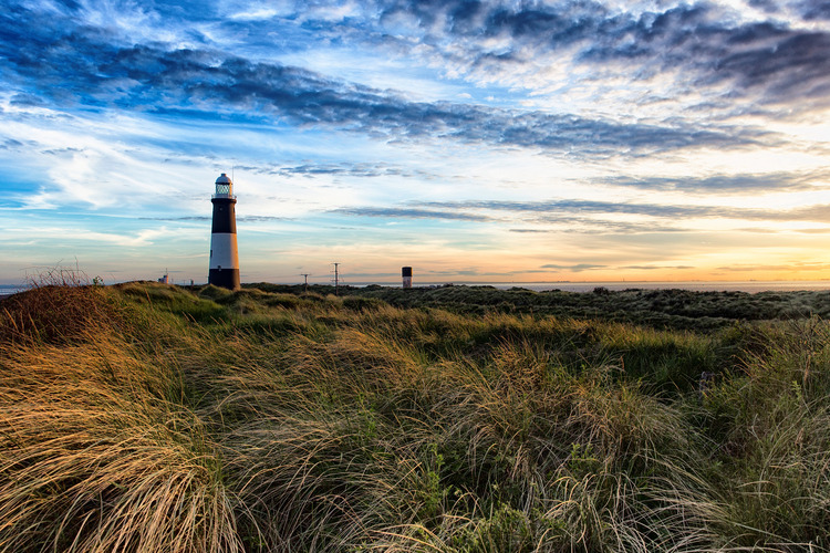
On maps or from the air, some of Britain’s coastal features are unmistakable. Among them is Spurn. This narrow spit of land sprouts from the north bank of the Humber Estuary.

Spurn’s curving shape has been compared to a bent knitting needle, a melted spoon and a giant tadpole wriggling out to sea. Views from the ground are equally dramatic.


Enjoying this article? Check out more of ‘Discovering Britain’:

  • Discovering Britain: Dee Estuary
  • Discovering Britain: Exploring Hadrian’s Wall
  • Discovering Britain: Edinburgh’s Arthur’s Seat
  • Discovering Britain: Exploring Salford Quays

From the mainland at Kilnsea, Spurn sweeps towards the horizon like a beckoning finger. During a family holiday in the 1990s, we drove along the road onto Spurn itself before parking near the egg-shaped tip, known as Spurn Head or Spurn Point.

Vague childhood memories include a constant ruffling breeze, plus feeling like being on a strange pier, flanked by vast expanses of water. More than five kilometres long, parts of Spurn are less than 50 metres wide.


Spurn Headland, Humber Estuary, East Riding of Yorkshire
The tip of Spurn Point. Image: Shutterstock

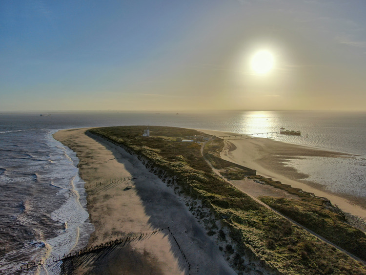
Spurn Point still attracts visitors today, notably many species of migrating bird. People, however, can only reach it on foot – and only at low tide. In December 2013 a storm surge breached the spit. Swathes of land, including the road, were swept away. Ever since, a stretch submerges at high tide and Spurn Point becomes an island. Yet this has always been a dynamic, evolving landscape.

Spurn was formed by longshore drift. The cliffs along the Holderness coast mainly comprise soft, easily eroded clays. Sand, gravel and sediment are swept southwards along the Holderness coastline.

At the Humber Estuary, prevailing winds and North Sea currents combine to sweep the material into a curved embankment. This continual process of deposition and erosion means Spurn’s size and shape change constantly.

Evidence exists in the remains of outmoded human activities. Besides the ruined road, there are abandoned groynes and two decommissioned lighthouses.


Go to the Discovering Britain website to find more hikes, short walks, or viewing points. Every landscape has a story to tell!

Filed Under: Culture Tagged With: Discovering Britain

Protected by Copyscape

Primary Sidebar

Subscribe to Geographical Magazine from just £4.99

Geographical subscriptions

Sign up to our newsletter and get the best of Geographical direct to your inbox

Popular Now

UK against trawling in protected seas in wake of Attenborough film

UK against trawling in protected seas in wake of Attenborough film

Abuse allegations rock Prince Harry-linked African Parks charity

Abuse allegations rock Prince Harry-linked African Parks charity

QUIZ: Name The Island!

QUIZ: Name The Island!

Death valley wandering rocks

Phenomena: Death Valley’s wandering rocks

A rotting apple on a white background

Nimble fingers to shrinking apples: Unlearning the junk science of school geography

Footer

  • Facebook
  • Instagram
  • LinkedIn
  • Reddit
  • TikTok
  • Twitter
  • YouTube

Geographical print magazine cover

Published in the UK since 1935, Geographical is the official magazine of the Royal Geographical Society (with IBG).

Informative, authoritative and educational, this site’s content covers a wide range of subject areas, including geography, culture, wildlife and exploration, illustrated with superb photography.

Click Here for SUBSCRIPTION details

Want to access Geographical on your tablet or smartphone? Press the Apple, Android or PC/Mac image below to download the app for your device

Footer Apple Footer Android Footer Mac-PC

More from Geographical

  • Subscriptions
  • Get our Newsletter
  • About Us
  • Contact Us
  • Advertise with us
  • Privacy policy
  • Terms & Conditions

Copyright © 2025 · Site by Syon Media