Discover the Sahara Desert’s fascinating past – and why climate change may make flooding a likely part of its future
By
Is it possible that one of the driest places on the planet could flood? With the recent news of intense rainfall in the Sahara just last month, the answer is yes.
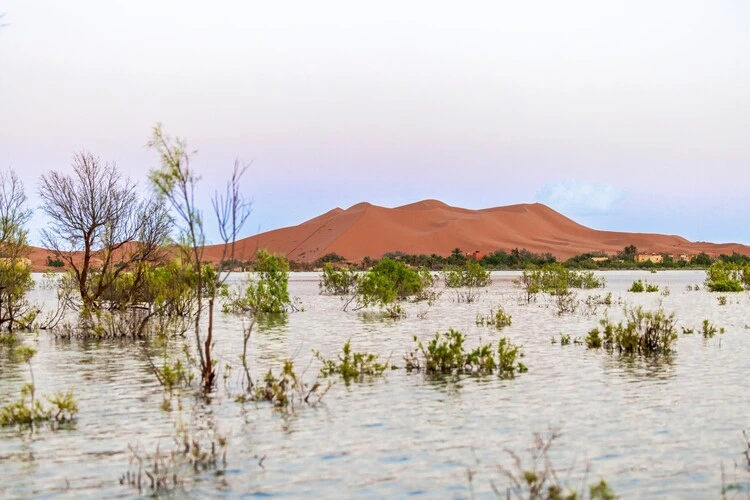
Usually experiencing just a few inches of rain in a year, the Sahara was hit by heavy rainfall – exceeding 8 inches in some places – in southeast Morocco over just two days, marking the first flood reported in the Sahara in more than half a century. Rain filled Lake Iriqui – previously dry for 50 years – and submerged the lower half of palm trees in water.
In the aftermath of such an unusual event, what remains is a concerning question: will such a phenomenon happen again?
The watery past of the Sahara
Today, it might be shocking to see the Sahara with lakes and rivers running through it from floods. But the Sahara wasn’t always dry.
Despite its scorching temperatures and vast expanses of sand, the desert was once, in fact, a vibrant, green expanse known as the ‘Green Sahara’ around 8000 years ago. Filled with trees, forests, and grasslands, the Green Sahara was caused by a series of monsoons that occurred during the African Humid Period.
After 3,000 years, a change in the earth’s orbit caused rainfall to reduce and vegetation to die and brought the famous desert to the appearance we are familiar with today.
These bouts of dryness followed by humidity are regular occurrences for the Sahara, with the current desert phase expected to last for another 15,000 years before the Sahara’s transformation again into a savannah.
Want to know more about the Sahara? Check out our related reads:
The Sahara was also once underwater, and home to several rivers between 50-100 million years ago, including a waterway – known as the Trans-Saharan seaway – that ran south from the Mediterranean, through the desert and then on to the Atlantic.
A 2019 study discovered that some of the biggest catfish and sea snakes in the world once resided in the Trans-Saharan seaway, with these marine creatures reaching staggering lengths of up to 12.3 metres.
So is the Sahara threatened by floods?
In research published this year by scientists at the University of Southern California, they stress droughts are no longer the main threat for a desert. Floods are.
The increasingly arid conditions of the Sahara – punctuated by intense rainstorms – is a combination of weather patterns becoming all the more common due to climate change. Because of rising natural temperatures, the water cycle has accelerated and become more unpredictable, leading to periods in the Sahara of too much, or conversely too little, water.
This dangerous cocktail of ever-changing conditions leads to worsening soil erosion and mud-flows that are difficult to control.
Think you know your deserts? Score high enough and win a prize…
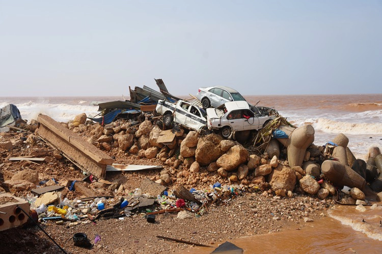
An example of these conditions proving deadly is the 2023 Storm Daniel that hit the eastern coast of Libya, the worst flood in Africa in a century. Leading to the deaths of more than 11,300 people, sweeping away entire neighbourhoods and leaving a further 40,000 Libyans displaced, the storm occurred due to high precipitation combined with the collapse of water infrastructure and two flood dams.
When these two dams broke, 30 million cubic meters of water headed towards the city of Derna, exacerbating the effects of Storm Daniel. Such damage highlights just how devastating flooding can be to the Saharan region.
In a recent study, researchers concluded that sediment within the water of Storm Daniel – present due to surface erosion – caused the density of flowing water to increase and led to a greater impact on the coastal cities of Derna and Susah.
Storms are also getting stronger. As cities expand, there too lies another issue: an increased population bringing about less organisation of policies such as those which increase disaster preparedness. When flooding occurs, this may mean that the effects are far more disastrous and widespread than they would otherwise be.
The future of the Sahara
The effects of Saharan floods are significant, impacting soil composition and wildlife in the region. Landscapes destroyed or altered via floods may also disrupt the migratory patterns of animals that use the desert sands. Therefore, it is vital that plans are devised to mitigate the impact of flooding in the Sahara.
Radar satellites, as well as more advanced earth observation programmes, may be part of the answer to tackling flooding in the desert.
By monitoring the surface of the Sahara, researchers can begin to grasp the region’s dynamics and the processes occurring to tackle changes before they become huge natural disasters with far-reaching impacts.
Researchers also stress that policymakers need to be aware of the increasing frequency of such events and adopt solutions which consider the long-term occurrence of flooding. Floods like those caused by Storm Daniel are not random natural disasters, but according to climate models will in fact increase in severity over time.
Considering that events like Storm Daniel in Libya could happen in heavily-populated across North Africa and the Arabian Peninsula, making appropriate plans will help to avoid disastrous impacts across many regions in the future.