Discover more about the Drake Passage that leads to Antarctica, and why its waters can be some of the roughest in the world…
By
Roaring winds. Speeding currents. Waves that can reach in excess of 65 feet. This is potentially what awaits travellers passing through the Drake Passage, a waterway that connects the Atlantic and Pacific Ocean, and is frequented by those heading to Antarctica as it provides the shortest sailing route from South America.
In total, around 800 ships have sunk in its waters, claiming around 20,000 lives – however many of these catastrophes were during the age of poor navigation and unstable boats.
Enjoying this article? Check out our related reads:
As tourism to Antarctica increases – up ten-fold since 1992 to more than 100,000 visitors in 2022-2023 – conversations about Drake Passage are becoming more common. Most tour operators acknowledge the fears that some passengers may have in undertaking the crossing, even offering alternative methods of transport, such as flights, to entirely avoid it.
Read on to learn more about Drake Passage and the reasons why such intense conditions can form there…
What is the Drake Passage?
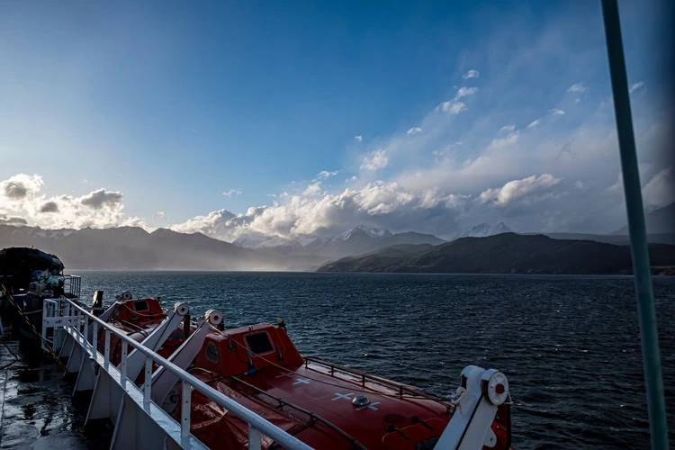
Located at the confluence of the Pacific, Southern and Atlantic Oceans, the Drake Passage is approximately 1,000km long (600 miles), with an average depth of around 11,000 feet (3,400 metres). Named after English Explorer Sir Francis Drake, it links the Atlantic and Pacific Ocean together between Cape Horn – the southern tip of the South American continent – and the northernmost point of the Antarctic Peninsula, the South Shetland Islands.
The passage also forms the shortest distance between Antarctica and any other landmass, with the average sailing take approximately two days, but up to six days in severe weather.
While the passage is often characterised by its rough weather, not every journey through the Drake Passage is so arduous. In fact, there are two nicknames that have been given to the opposing conditions the Drake Passage can experience: the ‘Drake Lake’ or ‘Drake Shake’.
Drake Shake vs Drake Lake
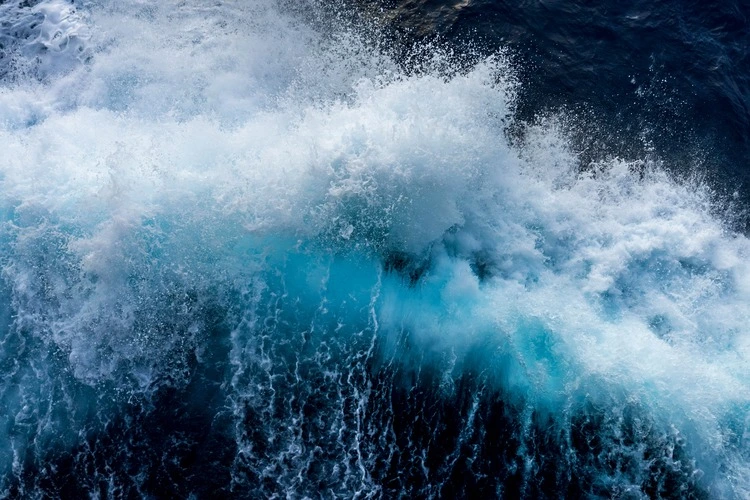
Drake Shake – which occurs around 30 per cent of the time – refers to the powerful waves and turbulent winds which can intensify seasickness and feature in many of the videos posted on social media of crossings.
To prevent against any mishaps at dinner, often ships are fitted with sticky mats to keep cutlery in place at meals, as physical oceanographer at the University of East Anglia Karen Heywood explains: ‘It’s always interesting when you go to dinner and they put sticky mats on all the tables to make sure your plates and things don’t slide around.’
In some rare instances, however, crossing in a Drake Shake can lead to deadly consequences. Back in 2022, one passenger died and four others were injured after a Viking Polaris ship was struck by a wave in the passage. During such dangerous weather, waves can reach up to 12 or 13 metres high.
Conversely, a Drake Lake is much more common weather pattern with bright skies and calmer winds, occurring in around 70 per cent of all journeys through the Drake Passage. Crossing in summer offers the best chance to avoid a Drake Shake, but even then there have been instances of choppy crossings in warmer months.
In either instance, boats which undertake the crossing of Drake Passage are fitted with features to help mitigate any discomfort for those onboard; from underwater stabilisers that reduce rolling on waves, to ships with an X-bow design that power through strong currents.
What can cause its choppy waters?
When bad weather strikes in the Drake Passage, it is the collective impact of several environmental factors that can whip up the conditions for stormy waters.
Firstly, at the passage’s latitude, there is no land to break winds that travel around the globe. Normally, landmass helps to dampen storms and wind, but instead these winds can continue on unobstructed, consequently picking up speed and hurtling at high intensity toward ships as they make their way through.
‘In the middle of the Drake Passage, the winds may have blown over thousands of kilometres to where you are,’ says oceanographer and head of open oceans at the British Antarctic Survey Alexander Brearley. ‘Kinetic energy is converted from wind into waves, and builds up storm waves.’
So significant can these winds be at such latitudes that they have acquired their own nicknames: the roaring forties, furious fifties and screaming sixties (each describing the incrementally stronger prevailing winds that occur at 40, 50 and 60 degrees latitude). Antarctica is roughly at 60 degrees latitude.
Another reason for choppy waters in the Drake Passage is the squeezing or ‘funnelling’ effect that occurs in the narrow length of the passage, intensifying storms as they pass through. Here is where the Antarctic Circumpolar Current is at its tightest point, carrying more than 130 million cubic metres of water per second through the passage, around 100 times more than all rivers discharge on the planet.
Water between the Antarctic and the southern hemisphere is essentially compressed, allowing it to surge through the two land masses and make a less-than-pleasant crossing for ships crossing between continents.
Despite its treacherous reputation for traversing via ship, some have crossed the Drake Passage in an altogether more unconventional method of transport: via rowing boat.
Back in 2019, US explorer Colin O-Brady – alongside a five-person crew – made history by becoming the first person to row through Drake Passage. Battling through 20 feet waves, intense seasickness and intense sleep deprivation – only sleeping for a maximum of one hour at a time – the expedition was completed in 12 days.