• Skip to main content
  • Skip to secondary menu
  • Skip to primary sidebar
  • Skip to footer
Geographical

Geographical

Official magazine of the Royal Geographical Society (with IBG)

  • Home
  • Briefing
  • Science & Environment
  • Climate
    • Climatewatch
  • Wildlife
  • Culture
  • Geopolitics
    • Geopolitical hotspots
  • Study Geography
    • University directory
    • Masters courses
    • Course guides
      • Climate change
      • Environmental science
      • Human geography
      • Physical geography
    • University pages
      • University of Aberdeen
      • Aberystwyth University
      • Cardiff University
      • University of Chester
      • Edge Hill University
      • The University of Edinburgh
      • Oxford Brookes University
      • Queen Mary University of London
    • Geography careers
      • Charity/non-profit
      • Education & research
      • Environment
      • Finance & consulting
      • Government and Local Government
    • Applications and advice
  • Quizzes
  • Magazine
    • Issue previews
    • Subscribe
    • Manage My Subscription
    • Special Editions
    • Podcasts
    • Geographical Archive
    • Book reviews
    • Crosswords
    • Advertise with us
  • Subscribe

Phenomena: The Darvaza Gas Crater

14 April 2025
2 minutes

Darvaza (Derweze) gas crater (Door to Hell or Gates of Hell) in Turkmenistan
The crater is filled with hundreds of natural gas fires. Image: Matyas Rehak/Shutterstock

Discover more about Turkmenistan’s ‘Gates of Hell’ – the fiery pit attracting both tourists and national concern


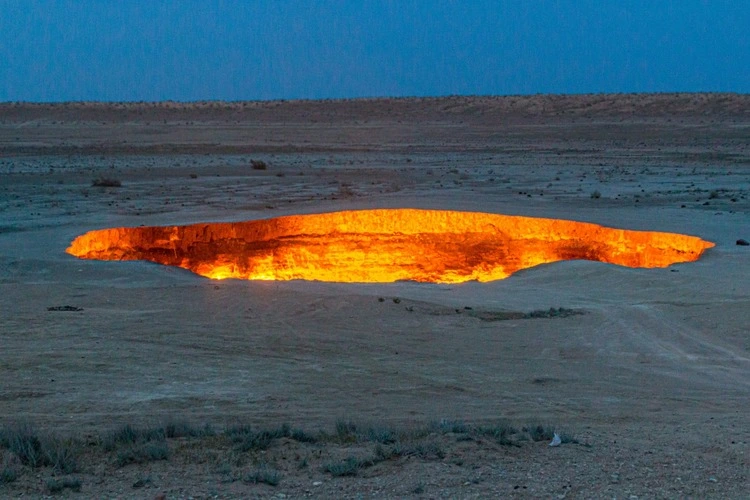
For more than half a century, an inferno has raged in the heart of Turkmenistan’s Karakum Desert. Known as the Darvaza gas crater or, more dramatically, the ‘Gates of Hell’, this fiery pit, a gaping wound in the Earth, located about 260 kilometres north of Turkmenistan’s capital, Ashgabat, has become both a tourist attraction and a source of national concern. Gurbanguly Berdymukhamedov, Turkmenistan’s president until 2022, repeatedly called for the flames to be extinguished, citing environmental damage, economic losses and potential health hazards.


Check out our other phenomena articles…

  • Phenomena: frozen methane bubbles
  • Phenomena: Maelstroms and whirlpools
  • Review: Hell Jumper – volunteering on Ukraine’s frontline
  • Phenomena: St Elmo’s fire explained
  • Phenomena: Sunken villages

It’s believed that the crater was formed in 1971 when a Soviet drilling accident led to a rig collapsing into a gas cavern. Turkmenistan has one of the world’s largest reserves of natural gas. The fires were probably started later to prevent the spread of poisonous gases. However, contemporary information about the disaster was deliberately destroyed, leaving no paper trail linking it back to the Soviet mining concern.

Regardless of the precise timeline, the Soviets, worried about toxic gases spreading, set fire to the escaping methane, likely anticipating that the flames would extinguish quickly. Now, more than 50 years later, it seems they vastly underestimated the reserves of natural gas present beneath the surface. The 70-metre-wide and 30-metre- deep crater, filled with hundreds of burning fires, can be seen from miles away.

In 2013, Canadian explorer George Kourounis became the first person to descend into the crater, describing it as a ‘Coliseum of fire’, its roaring sound similar to that of a jet engine. He said he felt ‘like a baked potato’ in his heat-resistant gear. The expedition aimed to collect soil samples to check for microbial life that can survive in such an extreme environment.

‘We are losing valuable natural resources’, declared former president Berdymukhamedov, ‘for which we could get significant profits and use them for improving the well-being of our people.’ However, despite this pronouncement and multiple attempts to douse the flames, the crater continues to burn.

Filed Under: Briefing

Protected by Copyscape

Primary Sidebar

Subscribe to Geographical Magazine from just £4.99

Geographical subscriptions

Sign up to our newsletter and get the best of Geographical direct to your inbox

Popular Now

Marauiá mountain range. Yanomami Indigenous Territory, state of Amazonas, Brazil, 2018

Remembering Sebastião Salgado

The lavender fields at Castle Farm

Discovering Britain: Darent Valley, earthly paradise

Map of Gulf of Mexico

Digital cartography on trial: Mexico sues Google for ‘Gulf of America’ label

Glaciologist Ricardo Jaña of the Chilean Antarctica Institute, research chief at the Union Glacier Joint Scientific Polar Station

Life, science and climate urgency on Antarctica’s Union Glacier

UK seas in hot water: the rising threat of marine heatwaves

UK seas in hot water: the rising threat of marine heatwaves

Footer

  • Facebook
  • Instagram
  • LinkedIn
  • Reddit
  • TikTok
  • Twitter
  • YouTube

Geographical print magazine cover

Published in the UK since 1935, Geographical is the official magazine of the Royal Geographical Society (with IBG).

Informative, authoritative and educational, this site’s content covers a wide range of subject areas, including geography, culture, wildlife and exploration, illustrated with superb photography.

Click Here for SUBSCRIPTION details

Want to access Geographical on your tablet or smartphone? Press the Apple, Android or PC/Mac image below to download the app for your device

Footer Apple Footer Android Footer Mac-PC

More from Geographical

  • Subscriptions
  • Get our Newsletter
  • About Us
  • Contact Us
  • Advertise with us
  • Privacy policy
  • Terms & Conditions

Copyright © 2025 · Site by Syon Media