• Skip to main content
  • Skip to secondary menu
  • Skip to primary sidebar
  • Skip to footer
Geographical

Geographical

Official magazine of the Royal Geographical Society (with IBG)

  • Home
  • Briefing
  • Science & Environment
  • Climate
    • Climatewatch
  • Wildlife
  • Culture
  • Geopolitics
    • Geopolitical hotspots
  • Study Geography
    • University directory
    • Masters courses
    • Course guides
      • Climate change
      • Environmental science
      • Human geography
      • Physical geography
    • University pages
      • University of Aberdeen
      • Aberystwyth University
      • Cardiff University
      • University of Chester
      • Edge Hill University
      • The University of Edinburgh
      • Oxford Brookes University
      • Queen Mary University of London
    • Geography careers
      • Charity/non-profit
      • Education & research
      • Environment
      • Finance & consulting
      • Government and Local Government
    • Applications and advice
  • Quizzes
  • Magazine
    • Issue previews
    • Subscribe
    • Manage My Subscription
    • Special Editions
    • Podcasts
    • Geographical Archive
    • Book reviews
    • Crosswords
    • Advertise with us
  • Subscribe

How a new tool will aid coastal erosion and flooding management across the world

15 April 2025
2 minutes

Coastal erosion at Mappleton, south of Bridlington, East Yorkshire coast. BGS © UKRI.
Coastal erosion at Mappleton, south of Bridlington, East Yorkshire coast. Image: BGS & UKRI.

British Geological Survey’s new tool will help both coastal erosion and flooding management across both UK and international shores


By Victoria Heath

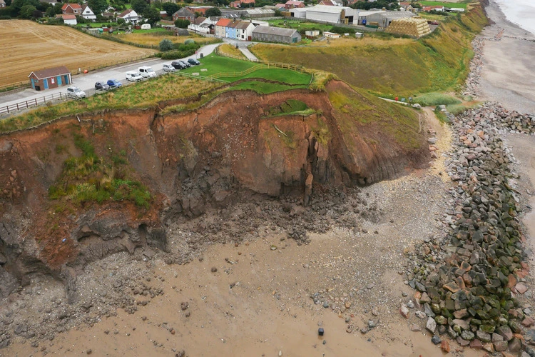
Each year, more than 28 per cent of England and Wales’ coastline experiences at least 10cm of erosion.

Now, a new tool developed by the British Geological Survey (BGS) will be used to predict how exactly coastlines change due to erosion and flooding – not just on UK shores, but worldwide.


Enjoying this article? Check out our related reads:

  • The rising threat of UK coastal erosion
  • Phenomena: The Eye of the Sahara
  • The online climate tool that Trump removed, but data scientists have now rebuilt
  • Why zapping electricity on our coastlines can help protect them
  • The popular beaches predicted to shrink the most by 2100

Known as CoastalME, the tool – created in partnership with the Environmental Change Institute (ECI) at the University of Oxford and the University of Southampton – simulates how coastal landforms interact with human interventions. Already in Spain, CoastalME has been utilised to assess flood and erosion risk across Andalusia’s entire 1,200km coastline, stretching across five of its eight provinces.

Within the UK, the tool has also been a fundamental part of the Resilient Coast Project funded by the government – a project where sediment’s release and transit is mapped to further research a sediment circular economy for East Anglia.

‘After years of developing CoastalME, we are pleased to see that it’s now been officially released and is now freely available to support coastal engineers and decision makers to better assess the risk of compound flooding and erosion more accurately than ever before,’ said Head of Coasts and Estuaries at the British Geological Survey Dr Andres Payo Garcia.

The damaging impacts of coastal erosion & flooding

By 2100 – thanks to both human activity and climate change – around half a billion pounds worth of residential property is expected to be lost in the UK due to coastal erosion, according to a survey from One Home.

Worldwide, its impacts are significant: in 30 years, erosion will have destroyed 36,000 kilometres of sandy coastlines. By 2100, scientists predict a further 95,000 kilometres – equivalent to 25.7 per cent of Earth’s beaches – will be entirely eroded.

Coastal flooding also impacts European coasts – by 2050, it is projected that 1-in-100 year coastal floods will hit regions in the Mediterranean and Atlantic coasts, and almost all remaining European costs by 2100.

Filed Under: Briefing Tagged With: coast

Protected by Copyscape

Primary Sidebar

Subscribe to Geographical Magazine from just £4.99

Geographical subscriptions

Sign up to our newsletter and get the best of Geographical direct to your inbox

Popular Now

Around the world in 3,576 days

Around the world in 3,576 days

New Oreans is one of the many cities in which Dyer has lived

The tourist trap paradox

QUIZ: Lakes and Seas

QUIZ: Lakes and Seas

Glowing clouds below sun during sunrise

A fading shine: why earth’s dimming glow spells climate trouble

The Zealandia reserve, with the suburbs of Wellington in the background

Into the urban jungle: how Zealandia became Wellington’s wild heart

Footer

  • Facebook
  • Instagram
  • LinkedIn
  • Reddit
  • TikTok
  • Twitter
  • YouTube

Geographical print magazine cover

Published in the UK since 1935, Geographical is the official magazine of the Royal Geographical Society (with IBG).

Informative, authoritative and educational, this site’s content covers a wide range of subject areas, including geography, culture, wildlife and exploration, illustrated with superb photography.

Click Here for SUBSCRIPTION details

Want to access Geographical on your tablet or smartphone? Press the Apple, Android or PC/Mac image below to download the app for your device

Footer Apple Footer Android Footer Mac-PC

More from Geographical

  • Subscriptions
  • Get our Newsletter
  • About Us
  • Contact Us
  • Advertise with us
  • Privacy policy
  • Terms & Conditions

Copyright © 2025 · Site by Syon Media