• Skip to main content
  • Skip to secondary menu
  • Skip to footer
Geographical

Geographical

  • Geographical Magazine home
  • Science & Environment
  • Climate
    • Climatewatch
  • Wildlife
  • Culture
  • Geopolitics
    • Gepolitical hotspots
  • Study Geography
    • University directory
    • Course guides
      • Climate change
      • Environmental science
      • Human geography
      • Physical geography
    • Top universities
    • Geography careers
      • Charity/non-profit
      • Education & research
      • Environment
      • Finance & consulting
      • Government
    • Applications and advice
  • Magazine
    • Issue previews
    • Subscribe
    • Podcasts
    • Discovering Britain
    • Book reviews
    • Crosswords & quizzes
    • Advertise with us

Mapping the 2019 UK General Election

16 December 2019
3 minutes

  • Share
  • Twitter
  • Facebook
  • Pocket
  • Pinterest
  • Flipboard
  • Reddit
  • WhatsApp
  • Copy Link
UK General Election 2019 results map

If the 2016 vote for Brexit was described as a political earthquake in the United Kingdom, then the 2019 general election is the equivalent to the tsunami that followed


By Benjamin Hennig

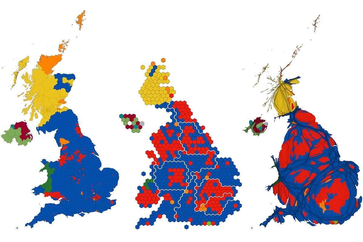
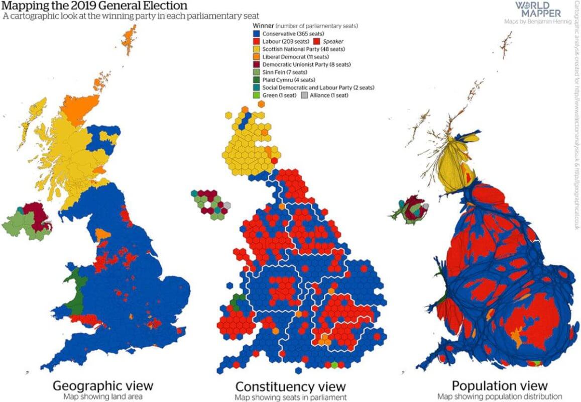
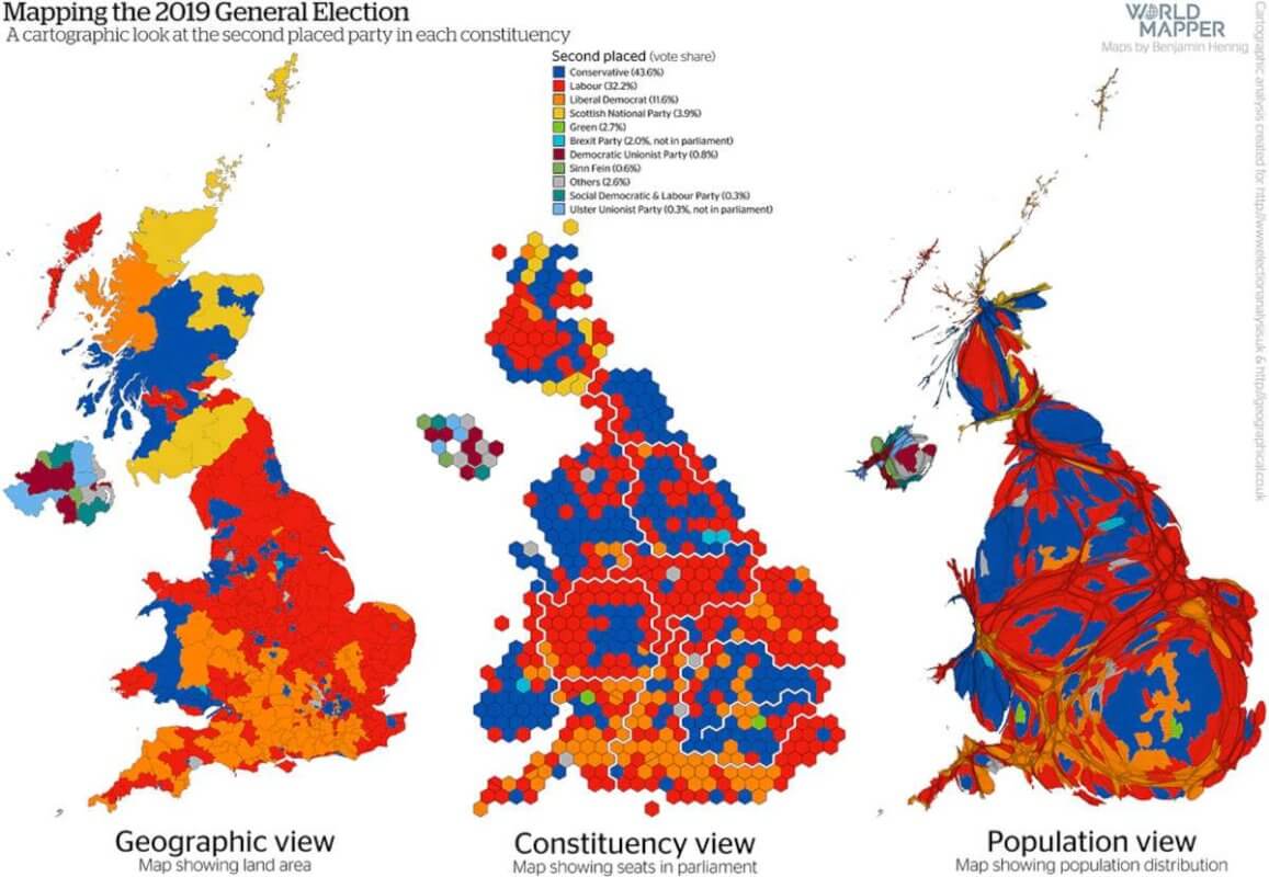
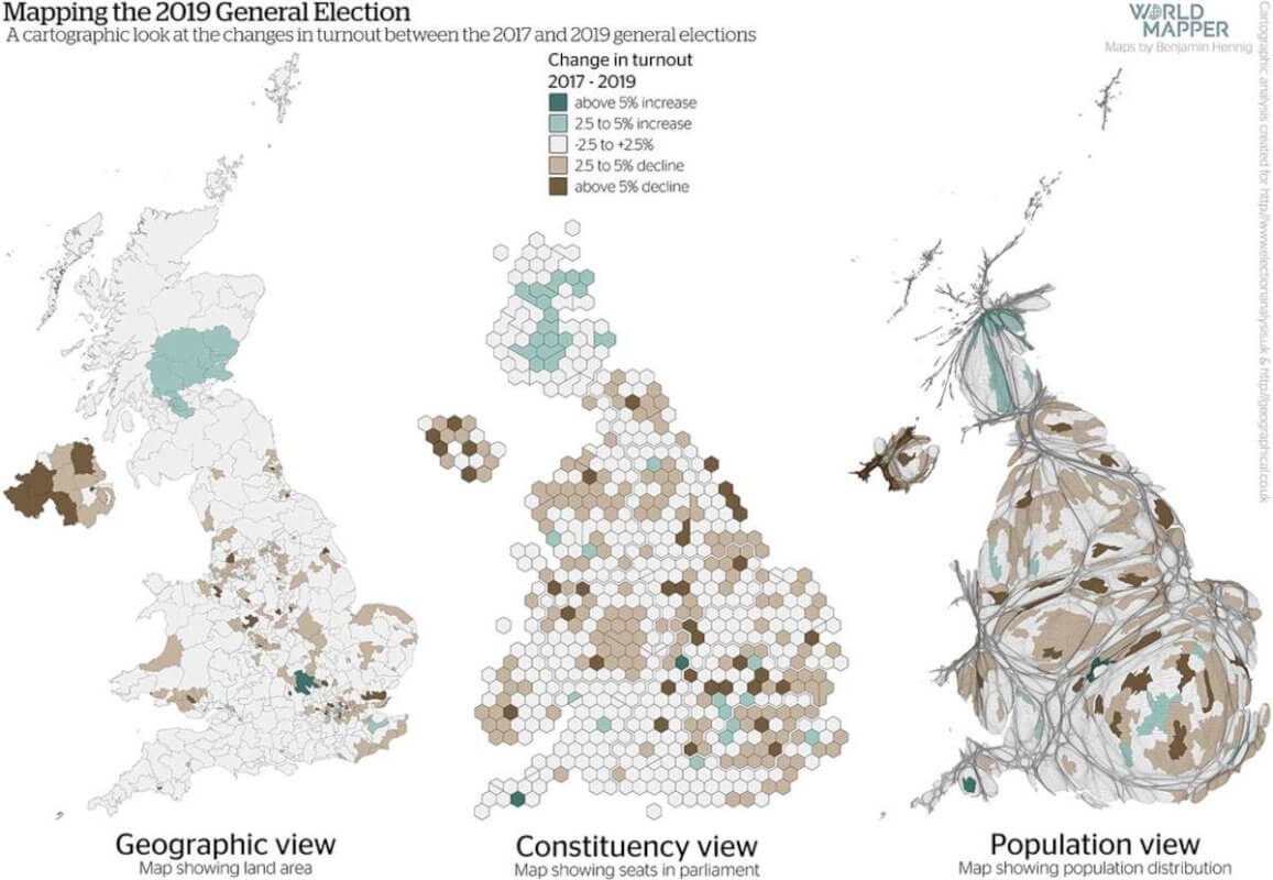
Approaching the outcome of the general election from a visual perspective puts metaphors about physical geographic upheavals into quite stark relief, as this cartographic analysis of the outcome of the December vote shows.

Political commentators spoke of a demolishment of the Labour party’s ‘red wall’ as the results came in during the election night. Yet, the ‘red wall’ that may have once stood was already a reality that had started to crumble in previous elections, while the Conservatives’ wins in 2019 clearly resemble the tsunami that swept into some of the deepest Labour heartlands in England.

Stay connected with the Geographical newsletter!

In these turbulent times, we’re committed to telling expansive stories from across the globe, highlighting the everyday lives of normal but extraordinary people. Stay informed and engaged with Geographical.

Get Geographical’s latest news delivered straight to your inbox every Friday!

In these cartograms, a series of different cartographic techniques is used to show how the political landscape in the UK is shaped and has changed since the last election in 2017, not only by physical space, but also by political dimensions as well as from a people’s perspective. The conventional (land area) map is complemented by a hexagon cartogram in which each parliamentary constituency is represented by a hexagon (some minor changes in constituencies in recent years are reflected in split and merged hexagons). There is also then a gridded population cartogram in which each area is resized according to the number of people living there (select each map to view a larger, higher-resolution version).

Each map therefore provides a different unique insight into the diverse geographical patterns of politics that emerged from the 2019 general election. To fully understand the new political realities of the United Kingdom that are going to have a significant impact on the politics of the years to come, only a combination of different perspectives as shown here can help to gain a more complete picture. Geography matters not only in its physical dimension, but just as much in the social and political spaces that are depicted in these maps.

Map showing the results of the UK 2019 general election
Map showing the change in winning parties from 2017-2019
Map showing second placed parties in each constituency
Map of UK general election 2019 voter turnout
Map showing the changing in UK voter turnout from 2017-2019
Map of the Conservative Party vote share 2019, UK
Map showing the vote share of the Labour party

These maps were created as part of a contribution for the UK Election Analysis 2019 published by the Centre for the Study of Journalism, Culture and Community in collaboration with Political Studies Association. The report including the full analysis that these maps were taken from is published online at www.electionanalysis.uk.

Stay connected with the Geographical newsletter!

In these turbulent times, we’re committed to telling expansive stories from across the globe, highlighting the everyday lives of normal but extraordinary people. Stay informed and engaged with Geographical.

Get Geographical’s latest news delivered straight to your inbox every Friday!

Benjamin Hennig (@geoviews) is Professor of Geography at the University of Iceland and Honorary Research Associate in the School of Geography and the Environment at the University of Oxford. He is also involved in the Worldmapper project (Worldmapper.org).

Subscribe to our monthly print magazine!

Subscribe to Geographical today for just £38 a year. Our monthly print magazine is packed full of cutting-edge stories and stunning photography, perfect for anyone fascinated by the world, its landscapes, people and cultures. From climate change and the environment, to scientific developments and global health, we cover a huge range of topics that span the globe. Plus, every issue includes book recommendations, infographics, maps and more!

  • Share
  • Twitter
  • Facebook
  • Pocket
  • Pinterest
  • Flipboard
  • Reddit
  • WhatsApp
  • Copy Link
Subscribe to our monthly print magazine!

Subscribe to Geographical today from just £3.40 per month. Our monthly print magazine is packed full of cutting-edge stories and stunning photography, perfect for anyone fascinated by the world, its landscapes, people and cultures. From climate change and the environment, to scientific developments and global health, we cover a huge range of topics that span the globe. Plus, every issue includes book recommendations, infographics, maps and more!

Filed Under: Geopolitics Tagged With: Elections, Mapping, Politics, UK

Protected by Copyscape

  • Share
  • Twitter
  • Facebook
  • Pocket
  • Pinterest
  • Flipboard
  • Reddit
  • WhatsApp
  • Copy Link

Related articles

Arctic nations are squaring up to exploit the region’s rich natural resources

Arctic nations are squaring up to exploit the region’s rich natural resources

Sweden and Finland to join NATO

Sweden and Finland to join NATO

Divided approaches in NATO to the war in Ukraine

Divided approaches in NATO to the war in Ukraine

How to see the world: centring the Indo-Pacific

How to see the world: centring the Indo-Pacific

China’s controversial security deal with the Solomon Islands

China’s controversial security deal with the Solomon Islands

Where will the Taliban’s refugee exodus go?

Where will the Taliban’s refugee exodus go?

  • Share
  • Twitter
  • Facebook
  • Pocket
  • Pinterest
  • Flipboard
  • Reddit
  • WhatsApp
  • Copy Link
Subscribe to our monthly print magazine!

Subscribe to Geographical today from just £3.40 per month. Our monthly print magazine is packed full of cutting-edge stories and stunning photography, perfect for anyone fascinated by the world, its landscapes, people and cultures. From climate change and the environment, to scientific developments and global health, we cover a huge range of topics that span the globe. Plus, every issue includes book recommendations, infographics, maps and more!

Footer

Geographical print magazine cover

  • Facebook
  • Instagram
  • Twitter
  • YouTube

Published in the UK since 1935, Geographical is the official magazine of the Royal Geographical Society (with IBG).

Informative, authoritative and educational, this site’s content covers a wide range of subject areas, including geography, culture, wildlife and exploration, illustrated with superb photography.

Click Here for SUBSCRIPTION details

Want to access Geographical on your tablet or smartphone? Press the Apple, Android or PC/Mac image below to download the app for your device

Footer Apple Footer Android Footer Mac-PC

More from Geographical

  • About Us
  • Contact Us
  • Advertise with us
  • Privacy policy
  • Terms & Conditions

Copyright © 2022 · Site by Syon Media

  • Facebook
  • Twitter
  • Pocket
  • Pinterest
  • Flipboard
  • Reddit
  • WhatsApp
  • Copy Link