The settlement of Hasankeyf, dating back thousands of years, will soon be lost to history as a hydroelectric power plant begins to fill its reservoir
By Abigail Spink
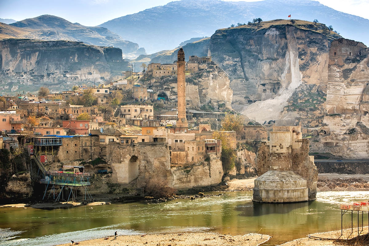
Located on the banks of the Tigris river and set into the soft limestone walls of the river valley, the Turkish town of Hasankeyf in Batman is a product of 12,000 years of human history. Famed for being part of Mesopotamia’s cradle of civilisation, the city dates to the Neolithic age and hosts remnants of numerous ancient cultures including Roman, Byzantine, Artukid, Ayyubid, Mongol and Ottoman. Each unique period of settlement is showcased in the town’s infrastructure; an intricate network of hand-carved caves, tombs, mosques, palaces, bridges, and a 330ft citadel proudly overlooking the Tigris.
The town is one of the most archeologically rich sites in modern Turkey and according to campaign group Hasankeyf Matters it remains ‘an extraordinary venue for understanding urban life in the middle centuries of Islamic civilisation – the period during which power shifted gradually from Baghdad and Cairo to Istanbul, Isfahan and Delhi’. Its notable position on the Silk Road meant it was a hub of commercial activity during the middle ages, acting as a staging point from Upper Mesopotamia to Anatolia.
Today, however, Hasankeyf better resembles a construction site than a place of worldly heritage thanks to the ongoing building of the Ilisu dam, a soon-to-be site of hydroelectric power production and mass water storage on the Tigris. Despite protests from residents and those campaigning to protect the cultural value of the town, it will soon be almost entirely submerged by the 45 million m³ Ilisu reservoir.
Ilisu is just one of 22 dams designed to support the 19 power plants that form part of the Southeastern Anatolia Project, based in the Kurdish region of southeastern Turkey. Despite huge social and environmental costs, the project was founded on the concept of sustainable development and aims to reduce disparities among nine million people living across nine provinces. As part of the project’s water resources program, the dams are intended to improve and manage irrigation, hydraulic energy production, forestry and agriculture, urban and rural infrastructure, as well as education and health in the region.

The Ilisu dam is being constructed across the upper Tigris, approximately 50km away from the Syrian and Iraqi borders. The reservoir created by the dam will stretch for 250 miles, inundating almost 200 settlements including Hasankeyf, and displacing up to 78,000 people. Although plans for the dam were first drawn up in 1954, construction did not fully begin until 2009 due to a lengthy period of both national and international protests. Credits provided by Turkish banks eventually set the project in motion ten years ago.
Now, the small, sleepy town of Hasankeyf, home to generations of families, is experiencing early stages of flooding and is being increasingly disturbed by machinery as monuments are relocated to a museum in the new town on the other side of the river. This settlement is known as the ‘new Hasankeyf’ and will feature an archeopark displaying irreplaceable artefacts from the old town, such as the Tomb of Zeynel Bey, as well as housing those who have been displaced.
While the loss of Hasankeyf is widely regarded as an archaeological tragedy, it seems that placing a time limit on the hundreds of historical sites found around the Tigris has initiated a sudden spell of activity. Dr Gül Pulhan, archeologist and coordinator of the SARAT project at the British Institute at Ankara, explains that: ‘The long-planned and contested Ilisu Dam on the Tigris River has provided a great opportunity for archaeologists to explore an unknown and unexplored part of Turkey, namely the Upper Tigris area.’
Pulhan is currently excavating Gre Amer, one of five sites that are still working this season before being eventually closed by the Ilisu project. Due to its position on a natural hill on the east bank of the Garzan tributary of the Tigris, Pulhan explains that it won’t be affected by the dam for at least another year. According to her reports, the name means ‘the mound of Omar’ in Kurdish and has enabled valuable insight into life during the Persian empire. Many objects retrieved from the site are on display in the Batman Museum.
Although Hasankeyf is not the focus of her current work, she took the time to reflect on its significance, claiming that the town ‘is a cultural obsession for the local people of Batman. The word archaeology is nearly synonymous with Hasankeyf. For years, when I tell someone that I am an archaeologist working in Batman they immediately question if I am working at Hasankeyf. When I say no and begin to describe where I was working, I’ve already lost their interest.
‘They don’t really know the history or archaeology of the place, but they associate themselves with it. They spend their weekends by the river eating kebabs, drinking tea or fishing. They have their wedding pictures taken there,’ she continues. ‘Now the whole place is a massive construction zone and in the midst of it are tour buses and bewildered domestic tourists. They don’t even know what they are looking at, the remains of the historic bridge is long-encased with ugly stones and concrete blocks – an effort to preserve it underwater.’
The upper town of Hasankeyf has been inaccessible since 2010 when, according to Pulham, a rock was dislodged and fell to the ground, killing one person. From 8 October, the whole town will be closed off to residents. Café owners and those living along the river edge are preparing themselves with jet skis and other equipment, but it appears they have little hope against the torrents of water due to arrive.
Set to quite literally go down in history, it is now hoped that the town’s reputation will in some way keep it alive. While future generations won’t get to experience Hasankeyf first-hand, Pulhan suggests they will hear of its charm for years to come because, as she puts it, ‘it is the most beautiful testimony of human creativity and the harmony between culture and nature.’


