• Skip to main content
  • Skip to secondary menu
  • Skip to primary sidebar
  • Skip to footer
Geographical

Geographical

Official magazine of the Royal Geographical Society (with IBG)

  • Home
  • Briefing
  • Science & Environment
  • Climate
    • Climatewatch
  • Wildlife
  • Culture
  • Geopolitics
    • Geopolitical hotspots
  • Study Geography
    • University directory
    • Masters courses
    • Course guides
      • Climate change
      • Environmental science
      • Human geography
      • Physical geography
    • University pages
      • University of Aberdeen
      • Aberystwyth University
      • Cardiff University
      • University of Chester
      • Edge Hill University
      • The University of Edinburgh
      • Oxford Brookes University
      • Queen Mary University of London
    • Geography careers
      • Charity/non-profit
      • Education & research
      • Environment
      • Finance & consulting
      • Government and Local Government
    • Applications and advice
  • Quizzes
  • Magazine
    • Issue previews
    • Subscribe
    • Manage My Subscription
    • Special Editions
    • Podcasts
    • Geographical Archive
    • Book reviews
    • Crosswords
    • Advertise with us
  • Subscribe

Climate risks could threaten 1 in 4 homes across England by 2050

17 December 2024
2 minutes

Wynyard, County Durham, UK: People are seen wadding back to their homes in Wynyard, County Durham this evening as heavy bank holiday rain showers caused flash flooding
Flooding from rivers, the sea and surface water is a risk for millions of homes across the UK, latest report reveals. Image: Jordan Crosby/Shutterstock

New Environmental Agency assessment reveals that 6.3 million properties are at risk of flooding in England


By Victoria Heath

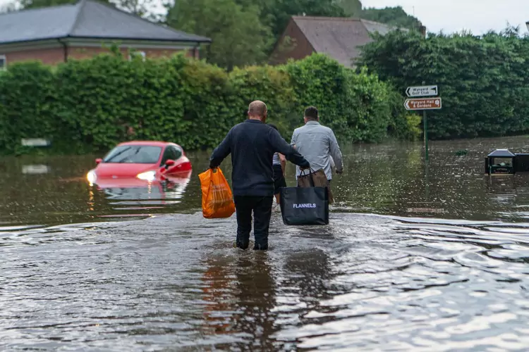
A new assessment from the Environmental Agency (EA) has revealed 1 in 4 homes across England could be at risk of flooding by 2050. The latest data shows that a total of 6.3 million properties are based in areas at risk of flooding from one – or a combination of – rivers, the sea and surface water.


Enjoying this article? Check out our related reads:

  • The warnings on climate change are clear
  • Are systemic risks a cause for concern to our planet?
  • COP29: More than 40 per cent of coral species face extinction

Around 4.6 million of these properties are in areas at risk of flooding from surface water, which occurs when such a high quantity of rainfall occurs so that drainage systems are blocked – leading to surface water runoff, also known as flash flooding. London is the most at risk from this type of flooding.

Compared to the EA’s previous assessment, the figure of 4.6 million is an increase of 43 per cent – but these changes are largely due to vast improvements in data analysis rather than genuine increases in flood risk.

Road closed sign in flooded road
The UK has become wetter over the last few decades, with Scotland experiencing the greatest increase. Image: Shutterstock

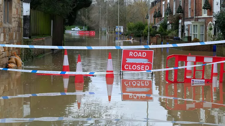
With climate change, the total number of properties in areas at risk from rivers and the sea or surface water could increase to around 8 million by the middle of the century, or around one in four properties.

Properties are defined at risk by the EA when the yearly chance of flooding is more than one-in-1,000.

As well as flooding, the updated assessment also considered the impact of coastal erosion risk and its impact on our shorelines. 3,500 properties are expected to be in areas at risk from coastal erosion in the period by to 2055, a figure that will then rocket to more than 10,000 properties by the end of the century.

‘The Environment Agency’s National Flood and Coastal Erosion Risk Assessment released today paints a stark picture: the impact of climate change is accelerating, with severe consequences for economies, communities, and industries worldwide,’ said senior ESG analyst at Hargreaves Lansdown, Tara Irwin.

However, severe flooding is not a certain reality for the UK’s future: by reducing greenhouse gases and using both natural and man-made flood defences, the impact of flooding can be mitigated.

Filed Under: Briefing

Protected by Copyscape

Primary Sidebar

Subscribe to Geographical Magazine from just £4.99

Geographical subscriptions

Sign up to our newsletter and get the best of Geographical direct to your inbox

Popular Now

July 2025 Geographical crossword

July 2025 Geographical crossword

Out now: July 2025’s Geographical Magazine

Out now: July 2025’s Geographical Magazine

Ocean waves produce two to three times the world’s total energy needs

How to harness the waves: from halting tsunamis to clean energy

QUIZ: Landforms

QUIZ: Landforms

Kewang member in the Haruku forest, Indonesia

Better World Video Awards 2025 – Kewang: Nature’s Ancient Guardians

Footer

  • Facebook
  • Instagram
  • LinkedIn
  • Reddit
  • TikTok
  • Twitter
  • YouTube

Geographical print magazine cover

Published in the UK since 1935, Geographical is the official magazine of the Royal Geographical Society (with IBG).

Informative, authoritative and educational, this site’s content covers a wide range of subject areas, including geography, culture, wildlife and exploration, illustrated with superb photography.

Click Here for SUBSCRIPTION details

Want to access Geographical on your tablet or smartphone? Press the Apple, Android or PC/Mac image below to download the app for your device

Footer Apple Footer Android Footer Mac-PC

More from Geographical

  • Subscriptions
  • Get our Newsletter
  • About Us
  • Contact Us
  • Advertise with us
  • Privacy policy
  • Terms & Conditions

Copyright © 2025 · Site by Syon Media