Rory Walsh follows the High Peak Trail to a large Stone Age tomb guarded by ancient elms
Discovering Britain
Trail • Rural • East Midlands • Web Guide
On weekends and bank holidays, most trains (and the tickets required to travel on them) are classed as ‘off peak’. In Derbyshire, this term can become rather complicated. The Peak District National Park is veined with disused railway lines. Among them is the Cromford and High Peak Railway, which walkers and cyclists now enjoy as the High Peak Trail. The High Peak Trail winds for 27 kilometres between Dowlow and Cromford. About halfway, the line passes an ancient terminus – the tumulus of Minninglow Hill.
‘Minninglow is somewhere that makes you think and ask questions,’ says Simon Corble, who created this Discovering Britain trail. ‘You can trace patterns of human activity here spanning thousands of years.’
Corble is a Peak District poet, playwright and photographer who grew up in neighbouring Cheshire. While studying drama at what is now Manchester Metropolitan University, he explored the surrounding area. ‘I became fascinated by the Peak District’s variety of landscapes and have remained loyal to it ever since,’ Corble says. ‘For someone with a curious mind, it’s a wonderful place to live.’
Corble’s walk begins at a small car park. When we arrive on Good Friday morning it’s already half full and almost every vehicle has a bike rack. Corble is unsurprised. ‘The High Peak Trail is one of the best walking and cycling routes in the Peak District,’ he says. ‘The scenery is stunning. It’s a great day out.’
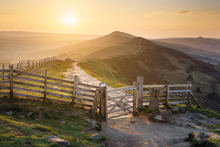
Our first steps on the trail follow a high ridge flanked by low walls. There are steep drops on either side. To the left are the distant summits of Dark Peak; to the right, the bulge of Minninglow Hill heads a farmland valley. There isn’t a cloud in sight as the path runs arrow straight between blue sky and green fields. Piebald sheep look like pebbles in the grass below. A gentle breeze carries their bleating, birdsong and the occasional sound of farm vehicles.
The ridge’s straightness is a clue to its former use. A more spectacular reminder appears when the path loops smartly to the right. By a metal gate, we look back at the ridge. We’ve just crossed the top of Minninglow Embankment. For Corble, ‘the embankment is one of the wonders of the Peak’. Its rugged grey flanks span the valley like a dam. Compared to famous Victorian viaducts, with their smooth brick sides and orderly arches, Minninglow Embankment looks weathered and almost ancient. ‘It always reminds me of an Aztec pyramid,’ Corble says. He also points out the neighbouring fields laced with drystone walls. ‘The embankment is basically a massive version, built using the same techniques and stone.’

Past the embankment, a carpet of greenery unfurls on our right as we continue along the valley. Brightly clad cyclists remain visible far ahead. The distant daubs of their colourful clothing illustrate the High Peak Trail’s course. ‘It’s very sinuous, snaking around the hills,’ says Corble. At Minninglow, the trail is easy going. Elsewhere, it passes through some major inclines. For example, at Middleton Top and Black Rocks, cyclists are advised not to ride downhill. When the Cromford and High Peak Railway opened in 1831, it had the steepest incline (1 in 14 at Hopton) and sharpest curve (80° at Gotham) on any British railway.
The challenging route made for tiring and time-consuming journeys. Corble explains: ‘Early railways were built like early canals, following the contours of the land. This made sense for carrying goods safely on water, but it meant the railway was terribly slow.’ The line’s original locomotives didn’t help. Corble continues: ‘I love that you follow the High Peak Trail picturing trains, but the curves are so tight and the inclines so steep you wonder how trains used it. The answer is that at first, the railway was horse-drawn.’
Steam engines succeeded horses by the 1860s. The change exacerbated another obstacle – local geology. Just before Minninglow Hill, the High Peak Trail suddenly enters a gorge scythed through an outcrop of limestone. ‘Peak District limestone is high-quality building material. The railway likely cut through here to quarry it,’ says Corble. Evidence of quarrying appears throughout the trail, from rough-hewn rock faces to the hulk of a crane rusting nearby. The limestone feels cool and sandpapery. If the railway and abandoned quarry seem old, gazing at and touching the rock puts them in context.
White Peak limestone formed 340 million years ago from the shells and bones of creatures compressed on the bed of a tropical sea. The stone’s origins proved ironic when the Cromford and High Peak Railway became steam-powered. ‘Steam engines need large amounts of water,’ Corble continues, ‘but porous Peak District limestone doesn’t have many water sources. Supplies had to be hauled here, 1,000 feet [305 metres]above sea level, from further away.’ More ironic still, the railway was a mineral line built to carry coal and quarried limestone between two busy canals. ‘There was a token passenger service,’ says Corble, ‘but it was so slow and uncomfortable that there was only one train per day.’ The railway’s remote, difficult and thirsty route saw the line close in 1967.
From the gorge, we climb Minninglow Hill. The ascent is gentle at first. Higher up, the ground becomes steeper and uneven. A ring of beeches stand like sentries at the summit, guarding the site within. As we enter, the air feels still. Time seems to stop. Gnarled and black, the bare trees cast shadows like giant hands upon the hummocky ground. Half hidden among the grass are flat limestone blocks. Together, they comprise a Neolithic chambered tomb – the largest in Derbyshire – and two Bronze Age barrows. ‘To our ancestors, this would have been a sacred place,’ says Corble. It remains magical today.
Maps show that almost every hill, or ‘low’, in the Peak District has a tumulus on top. Corble reveals that ancient paths used to link each one. We leave Minninglow Hill using a modern path down the opposite side. We take a more sedate pace than two hares, which sprint over the grass. At the bottom of the hill, we join another historic route. The medieval lane of Minninglow Grange leads past a large farm. At a crossroads with the High Peak Trail, Corble points out a change underfoot. The High Peak Trail is lined with crushed limestone, but the lane beyond is sandy. ‘A layer of silica sand was carried downhill here by a long-lost Miocene river. The railway builders uncovered it by chance. The sand was used to make bricks, which were transported to Sheffield on the railway.’
Before we return to the car park, we look back at a view Corble describes as ‘a geographical layer cake’. At the top is the tumulus on Minninglow Hill. The railway embankment and disused quarries stack up below it, while the drystone walls and farm tracks in the foreground have medieval origins. ‘The Peak District has always been a difficult place to get around,’ Corble reflects. ‘Even today, transport links with surrounding parts of the country are difficult.’ Minninglow reveals how people crossed the Peak District plateau from the Stone Age to the Railway Age, with plenty of highs and lows in between.
Discover more about Britain…